
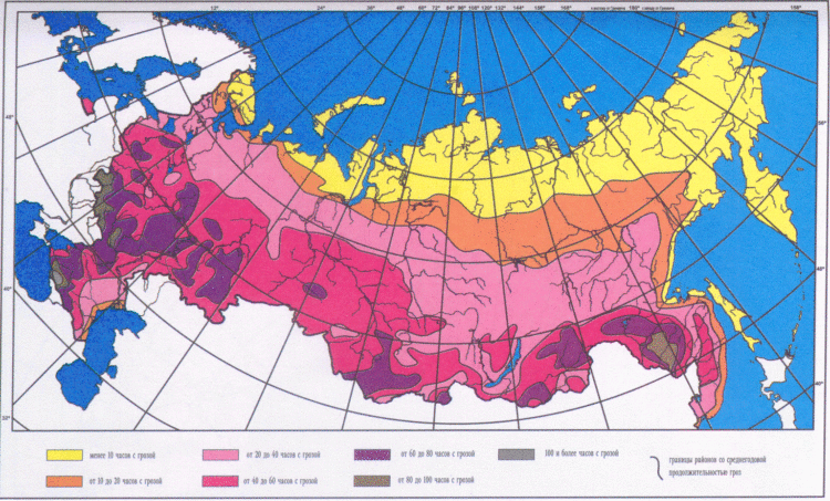
Map of climate zones. Basic and transitional climate zones of the earth
Territory Russian Federation very vast and occupies a huge landmass earth's surface. It stretches for thousands of kilometers across Eurasia, is washed by the seas of three oceans, and contains a colossal number of rivers and lakes. The surface relief varies from steep mountains to the lowlands below sea level.
Russia includes almost all the climatic zones that exist on Earth - from hot subtropical to icy arctic.
In the north-west of Russia there is a maritime climate. When moving towards the center of the Russian Federation, it changes to continental climate and further - to the subtropical in the city of Sochi, next to the Black Sea. In Siberia the climate is sharply continental, and on Far East Monsoons reign. All this is the result of the significant extent of the territory of the Russian Federation from east to west and from north to south.
Climate zone- this is a wide area of the earth's surface, within which an approximately homogeneous climate is created throughout the entire length of such an area. The Earth is divided into 4 conventional main zones: polar, temperate, subtropical and tropical. Basically, natural-climatic zoning arises due to different heating of the Earth's surface by its luminary - the Sun. The main division occurs along the meridians. Inside Russia, the division into climatic zones basically coincides with the twentieth, fortieth, sixtieth and eightieth meridians - that is, multiples of 20.
To determine the temperature of a comfortable operating mode for suits and jackets, tests were carried out in a specialized climatic chamber of the Research Institute of MT of the Russian Academy of Medical Sciences
| 1 ZONE | Astrakhan region Belgorod region Volgograd region Kaliningrad region Republic of Kalmykia Rostov region Stavropol region Republic of Adygea Republic of Dagestan Republic of Ingushetia Kabardino-Balkarian Republic Karachay-Cherkess Republic Republic North Ossetia– Alania Chechen Republic Krasnodar Territory |
| ZONE 2 | Bryansk region Vladimir region Voronezh region Ivanovo region Kaluga region Kursk region Leningrad region Lipetsk region Republic of Mari El Republic of Mordovia Moscow region Nizhny Novgorod region Novgorod region Oryol region Penza region Primorsky Krai Pskov region Ryazan region Samara region Saratov region Smolensk region Tambov region Tver region Tula region Ulyanovsk region Chuvash Republic Yaroslavl region |
| ZONE 3 | Altai Republic Amur Region Republic of Bashkortostan Republic of Buryatia Vologda Region Irkutsk region(except for the areas listed below) Republic of Karelia Kemerovo region Kirov region Kostroma region Krasnoyarsk region(except for the areas listed below) Kurgan region Novosibirsk region Omsk region Orenburg region Perm region Sakhalin region (except for the areas listed below) Sverdlovsk region Republic of Tatarstan Tomsk region (except for the areas listed below) Republic of Tyva Tyumen region (except for the areas listed below) Udmurt Republic Khabarovsk region(except areas listed below) Chelyabinsk region Chita region Republic of Khakassia Transbaikal region |
| 4 ZONE | Arkhangelsk region (except for areas located beyond the Arctic Circle) Irkutsk Region (regions: Bodaibinsky, Katangsky, Kirensky, Mamsko-Chuysky) Kamchatka Region Republic of Karelia (north of 63°N latitude) Komi Republic (regions located south of the Arctic Circle) Krasnoyarsk Territory (territories of Evensky Autonomous Okrug and Turukhansk region, located south of the Arctic Circle) Kuril Islands Magadan region (except for the Chukotka Autonomous Okrug and the areas listed below) Murmansk region Republic of Sakha (Yakutia) (except for the Oymyakonsky region and areas located north of the Arctic Circle) Sakhalin region (districts: Nogliki, Okha) Tomsk region (districts: Bakcharsky, Verkhneketsky, Krivosheinsky, Molchanovsky, Parabelsky, Chainsky and territories of Aleksandrovsky and Kargasoksky districts located south of 60°N latitude) Tyumen region (regions of the Khanty-Mansiysk and Yamalo-Nenets autonomous circles, except for areas located north of 60°N latitude) Khabarovsk Territory (districts: Ayano-Maisky, Nikolaevsky, Okhotsky, named after Polina Osipenko, Tuguro-Chumikansky, Ulchsky) |
| SPECIAL ZONE | Magadan region (districts: Omsukchansky, Olsky, North-Evensky, Srednekansky, Susumansky, Tenkinsky, Khasynsky, Yagodninsky) Republic of Sakha (Yakutia) (Oymyakonsky district) Territory located north of the Arctic Circle (except Murmansk region) Tomsk region (territories of the Aleksandrovsky and Kargasoksky districts, located north of 60°N latitude) Tyumen region (regions of the Khanty-Mansiysk and Yamalo-Nenets Autonomous Okrug, located north of 60°N latitude) Chukotka Autonomous Okrug Nenets Autonomous Okrug |
The entire north of Russia and the Northern Islands Arctic Ocean located in the Arctic and subarctic zones; middle lane The Russian Federation has temperate climate ic belt. The south is located in the subtropics, but it is very insignificant - even 5% of the territory of the Russian Federation is not included in this zone.
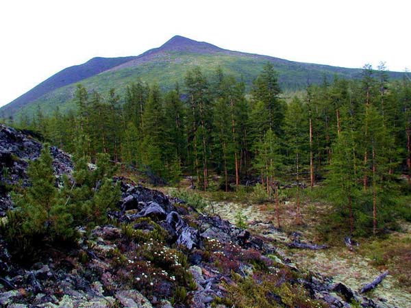
 The coldest point on the territory of the Russian Federation is the “pole of cold”, located near the city of Verkhoyansk (pictured). The thermometer can drop to -62 degrees Celsius. While Sochi, being in the subtropical zone, can boast temperatures up to +38 Celsius in July. But this is not a record - the absolute maximum in Russia was recorded at +45.4°C, at the Utta weather station, Kalmykia.
In the European part of the Russian Federation, the climate is more moderate. In Moscow in January average temperature is in the range between –9 °C and –16 °C, and in July from +13 °C to +23 °C.
Arctic climate of Russia
 Tundra and arctic deserts are located here. The conditions are so harsh because the soil hardly warms up - the rays of the Sun only glide across the surface of the planet here, without transmitting enough heat. Animal and plant worlds V arctic climate poor due to lack of food. Polar nights intensify negative influences The climate is harsh and temperatures can drop to minus 60 degrees Celsius in winter. The duration of winter is approximately 10 months, and in summer the earth does not have time to receive enough heat, because... Summer in this climate lasts no more than 2 weeks, with temperatures up to +5.
In the Arctic Ocean, winter temperatures are slightly higher, which is explained by heat transfer from water masses air.
 You may also be interested in learning about the choice of insulation materials for working in extremely cold conditions. weather conditions. You can read more about this in our material about.
What is holofiber and why is it better than traditional insulation, like padding polyester -.
Subarctic belt
Winter in subarctic climates is cold and long, but less severe than in the Arctic zone. Summer is only 5-7 degrees warmer, but also short. Precipitation occurs more often, but it is less abundant than in the Arctic climate. Arctic cyclones pass here very often.
Climate of the temperate zone of Russia
 Temperate zone largest in area, length and population in the Russian Federation. The seasons are clearly expressed: autumn, winter, spring and summer.
The temperate zone is divided into 5 regions due to noticeable differences in climate between them:
- The Sea of Okhotsk and Magadan are located in the maritime climate region;
- Half of the Amur River flowing into the Sea of Okhotsk and the city of Vladivostok are in the monsoon climate region;
- Yakutsk, Chita and Lake Baikal belong to the region of sharply continental climate;
- Krasnoyarsk and Tobolsk are located in the continental climate region;
- St. Petersburg, Moscow and Astrakhan are located in the temperate continental climate region.
Temperate continental climate zone of the Russian Federation
There are hot summers (up to +30°C) and frosty winters (up to –30°C). Temperature range over the year is up to 60 degrees. The climate is formed under the influence of Atlantic air masses. Due to different soil and air moisture levels, natural zones vary from taiga to steppe.
Continental climate zone of Russia
 It is formed under the influence of air masses coming from the west. At the same time, moving in the opposite direction air masses from the north and south they meet and this results in threefold more precipitation than in the south. The average temperature in July reaches +26°C, in January – down to –25°C. Natural areas This climate has a wide diversification along the path of their entire length, from frozen taiga to steppes with emerald grass.
Sharply continental climate
The air rules here temperate latitudes. Characteristics this climate - partly cloudy and a small amount atmospheric precipitation. The earth's surface quickly warms up in summer and cools down in winter, resulting in hot summers and frosty winters. In winter, the soil freezes heavily.
Monsoon and maritime climates
 In winter, atmospheric pressure increases, so cold and dry air masses rush to the ocean, where the air is warmer (water cools more slowly). When summer arrives, the continent warms up better than the water bodies (they take longer to do this), and cold air rises to the continent. This is why strong winds arise, which are called monsoons, which gives the name to the climate.
Sometimes there are typhoons here. Precipitation in summer is frequent and heavy. Floods are common. Summers here are cool (15-20°C in July), and winters are cold, down to –40°C (average 25°C). Near the sea itself, the climate is more moderate, both in summer and winter.
Subtropical climate zone of the Russian Federation
There are almost no subtropics in Russia - only a couple of noticeable cities huddled on a narrow strip of the Black Sea coast on the Caucasus Mountains. They are closing the coast warm sea from masses of cold air that move from the East European Plain. In the coldest month, the temperature does not drop below zero degrees. Summer is not hot, as for a subtropical climate, but long. There is a lot of precipitation due to the proximity of the mountains, but with an even distribution throughout the year.
There are no other climatic zones (equatorial, tropical) in Russia.
Road climatic zoning in Russia
The road climatic zone is a part of the country’s territory characterized by homogeneous building features highways, approximately the same climatic conditions, average homogeneity of the water surface and approximately similar indicators of soil freezing and groundwater depth.
Brief characteristics of road climate zones
| Road climate zones | Approximate boundaries and brief description each of the road climate zones |
| 1 | Cold tundra, covered with forest and permafrost are located north of the line of designated cities: De-Kastri - Birobidzhan - state border - Kansk - Tunguska - Sukhaya - Oshkurya - Nes - Ponoy - Monchegorsk. |
| 2 | Forests with constantly abundantly moistened soils are located from line 1 to the border of line 2: state border - Kansk - Tomsk - Kyshtym - Ustinov - Gorky - Tula. |
| 3 | Next lies the forest-steppe with periodically abundantly moistened soils: Turan - Biysk - Omsk - Magnitogorsk - Kuibyshev - Belgorod - Kirovograd - Chisinau. |
| 4 | In zone 4 you will no longer find abundantly moist soils. Line Volgograd – Kizlyar – Buynaksk – Stepanakert – Julfa. |
| 5 | The last, fifth zone is located southwest of zone 4. It includes desert areas with arid climate and very salty soils. |
Why do we need climate zones?
Climate zones- this is a conditional division of the space of a country or planet into regions with different climates, which affects the diversity of living conditions. Climatic zones are studied by humanity in order to understand optimal conditions for the development of a particular territory. As a rule, living in cold zones requires more expenses, but they contain more natural resources - useful resources and fossil fuels. Hot zones are good for farming, farming and recreation. Temperate zones suitable for the life of the majority of the population.
Where knowledge about climate zones is used
Knowledge about climatic zones used for a wide range of needs:
- When constructing buildings, structures. Each construction project must take into account the characteristics of the terrain. For buildings, this is the thickness and material of the walls, the presence or absence of waterproofing of the foundation, the density and type of roof material, the need for deep communications, etc.
- When designing utilities– use of material, the need for additional protection from cold or heat, the need to use special structural materials.
- When building roads– thickness of the coating, the need for additional strengthening or elevation of the soil, the possibility of laying overhead or only underground communications and their protection.
- When planning production natural resources – what design of wells, plants and communications should be used.
- When assessing the possibility of habitation of people– whether it is recommended or not for people to live in specific conditions, an assessment of their living and working conditions, which determines the complexity of building cities and the amount of payment to workers for the presence or absence of extreme conditions.
- When laying railways – frequency of piles, number of fastenings, construction budget.
- IN agriculture, fish farming and plant growing– which species can live in such a climate and which cannot; the profitability of such an enterprise as a whole.
- When planning resorts, being tied not only to the climate, but also to the characteristics of a particular place. This could lead to the appearance of ski and balneological resorts, popular beaches and health-improving salt caves.
Climate zones There are basic and transitional. The main climatic zones have a constant pattern of air movement throughout the year. In transitional areas, signs of two main zones are observed depending on the time of year. The main types include:
1. Equatorial belt
Located on both sides of the equator. It is characterized by a constant air temperature (24°−26°C), temperature fluctuations at sea are less than 1°C. Maximum solar heat is observed in September and March, when the sun is at its zenith. During these months the maximum falls. The annual precipitation is about 3000 mm; in the mountains, precipitation can reach 6000 mm. Precipitation usually occurs in the form of showers. There are many wetlands, dense multi-tiered wetlands with an exceptional diversity of flora and fauna. For most cultivated plants, high moisture is favorable, so in the equatorial zone two harvests are harvested per year.
The equatorial climate zone includes rain forests the left tributaries of the Amazon, the Andes of Ecuador and Colombia, the coast of the Gulf of Guinea, Cameroon, the right tributaries of the Congo, the upper Nile, the southern half of the island of Ceylon, most of the Indonesian archipelago, parts of the Pacific and Indian oceans.
2. Tropical zone
Tropical climatic zones in the North and Southern Hemisphere cover year-round areas high pressure. In the tropics, the atmosphere over the continent is different, so the oceanic tropical climate and mainland tropical climate. Oceanic is similar to, differing only in stable winds and less cloudiness. Summers over the oceans are warm, about +25°C, and winters are cool, on average +12°C.
A high pressure area prevails over the land, and rain is rare here. The mainland climate is characterized by very hot summers and cool winters. Daily air temperatures can change dramatically. Such changes lead to frequent dust storms.
The lush forests are always warm and humid. There is also a lot of rainfall here. The tropical climate zone includes Africa (Sahara, Angola, Kalahari), Asia (Arabia), North America (Cuba, Mexico), South America (Peru, Bolivia, Chile, Paraguay), and the central part of Australia.
3. Temperate zone
The temperate climate zone is far from homogeneous. It has distinct seasons, unlike the tropical and. The maritime climate is continental. All zones differ in average annual precipitation and characteristic vegetation.
Marine dominates in the west of North and South America and Eurasia. There are many cyclones here, so the weather is unstable. In addition, the westerly winds blow, bringing all year round precipitation. Summer in this zone is warm, about +26°C, winter is cold, from +7°C to −50°C. Continental predominates in the center of continents. Cyclones penetrate here less often, so it is warmer and dry summer and more cold winter.
4. Polar belt
Forms two belts: Antarctic and Arctic. The polar belt has unique feature- the sun does not appear here for several months in a row (polar night) and the polar day also lasts a long time when it does not go beyond the horizon. The air is very cool, the snow does not melt almost all year.
Transition zones include:
1. Subequatorial belt
The northern belt includes: Isthmus of Panama, Venezuela, Guinea, Sahel in Africa, India, Myanmar, Bangladesh, South China. Southern belt covers the Amazon, Brazil, central and eastern Africa, northern Australia. In summer, equatorial air masses dominate here. There is a lot of precipitation, the average temperature is +30°C. In winter, the subequatorial zone is dominated by tropical air masses, the temperature is about +14°C. The territory of this climatic zone is very favorable for human life; it is here that many civilizations arose.
This zone is dominated by either a Mediterranean or subtropical climate. There is a lot of precipitation almost all year round, so it is particularly diverse. Sub tropical zone covers the Mediterranean, the southern coast of Crimea, Western California, southwestern Africa and Australia, southern Japan, Eastern China, northern New Zealand, Pamir and Tibet.
3. Subpolar climate.
This climate zone is located on the northern outskirts North America and Eurasia. In summer it is cool here (+5°C-10°C), in winter arctic air masses come here, winters are long and cold (up to -50°C).
§ 38. Climatic zones
Remember that air masses are distinguished depending on the area of their formation.
Climatic zones. Climatic zones are latitudinal strips of the earth's surface that have a relatively uniform climate. The belts differ from each other in air temperature and superior air masses, which, according to their properties, determine the main features of the climate of the belt. Climatic zones change from the equator to the poles, i.e. zonally. There are 7 main climatic zones: equatorial, Two tropical, Two moderate and two polar (arctic And Antarctic) - One in each hemisphere. In each of them, one air mass dominates throughout the year - equatorial, tropical, temperate, arctic (Antarctic), respectively.
Between the main belts in each hemisphere there are formed transitional climate zones: subequatorial, subtropical And subarctic (subantarctic) . They are called sub-belts - From the Latin “sub” means “under”, that is, under the main ( pidequatorial, pidtropical, etc.). In transitional zones, air masses change seasonally. They come from neighboring main belts: in summer the air mass to the south of the main belt reigns, and in winter - to the north. For example, in the subequatorial zone, equatorial air reigns in the summer - the wet season of the year begins, in the winter tropical air enters - the dry season begins. Therefore, the climate of the subequatorial zone in summer is similar to the climate of the equatorial zone, and in winter it is similar to the tropical climate.
The map of climatic zones clearly shows that their boundaries do not run strictly along parallels, but deviate either north or south. This is explained by the influence of the third Climate-forming factor - the underlying surface: oceans, land, relief, currents, ice cover.
Within climatic zones, climatic regions with different types of climates are distinguished: Continental and maritime, the peculiar climate of the western and eastern coasts of the continents.
Rice. Climate zones
Main types of climate. In different territories under the same influence Climate-forming factors is formed certain type climate. The name of the climate type is determined by the name of the climate zone (equatorial, subtropical, tropical, temperate climate, etc.), the subtype of air masses (Marine, continental climate), and the characteristics of temperature and humidity.
U equatorial belt humid equatorial air masses predominate. Air temperatures are high (24 ... 28 0 C). Rising air currents generate powerful cumulonimbus clouds, which bring showers and thunderstorms every day. The occurrence of large amounts of precipitation per year (over 2000 mm) is also facilitated by the trade winds, bringing humid oceanic air. The temperature and amount of precipitation remain almost unchanged throughout the year.
For subequatorial belts characterized by seasonal changes in air masses. The summer monsoon brings equatorial air, the winter monsoon brings continental tropical air. Therefore, in summer it is hot and humid, like in the equatorial zone. And in winter the temperature drops slightly (20 0 C, low humidity, no precipitation. Such a climate with wet summers and dry winters is called monsoon. Deciduous forests are growing.
U tropical zones Dry tropical air masses dominate. There is high atmospheric pressure and downward air movement. The temperature in summer is very high (35 0 C), in winter it drops slightly (20 0 C). Very large daily amplitude of fluctuations (30-40 0 C). The tropical air is too dry, so there is generally little precipitation. Based on the amount of precipitation in this belt, climatic regions with different types of climate. tropical desert climate (precipitation is almost absent, only heavy dew and dense fog are formed) formed on the western coasts of continents, which are washed by cold currents. tropical wet climate (a lot of precipitation - over 1000 mm per year) dominates on eastern coasts continents that are washed by warm currents.
U subtropical zones climate is formed under the influence seasonal change of air masses: tropical in summer, temperate in winter. Continental subtropical The climate is dry, with hot summers and cool winters. On the western coasts of the continents the climate subtropical Mediterranean with hot, dry summers and mild, wet winters. On the eastern coasts the climate monsoon(Summer is hot, humid, winter is cool, dry). Inland climate sharply continental(Cool summer, harsh winter, some precipitation).
U temperate zones moderate air masses and westerly winds, cyclones and anticyclones prevail. There are well-defined seasons with positive temperatures in summer and negative temperatures in winter. There is a lot of precipitation, but it is unevenly distributed: much in the west of the continents, little in the interior regions, and enough in the east. Various climatic regions have formed in the belt. Continental temperate The type of climate (from moderate continental to sharply continental) is common in the interior regions of the continents. On the western coasts of the continents is formed marine temperate climate, in the east - monsoon.
Subarcticі subantarctic belts Seasonal changes in air masses are also typical: temperate ones dominate in summer, and arctic ones in winter. Summer is cool (10 0 C) and damp, winter is harsh (-40 0 C), long and with little snow. There is little precipitation - 200 mm per year. Permafrost is widespread - freezing rocks to great depths (up to 500 m). Maritime climate with cool summers and mild winters observed around the Arctic Ocean and Antarctica.
U Arctic (Antarctic) belt Cold and dry Arctic (Antarctic) air masses predominate. Air temperatures are negative throughout the year. There is very little precipitation - 100 mm per year.
Climate plays an important role in the living and nonliving nature of the Earth. It determines the distribution of soils, vegetation and fauna, the condition of rivers, lakes, seas, and glaciers.

Rice. Arctic belt

Rice. Tropical zone

Rice. Subequatorial belt
Climate map. Climate maps can help you understand the complex formation and distribution of climates on Earth. They contain data on the main elements of climate: the temperature of the warm and cold months (January and July), wind direction, and amount of precipitation. Average air temperature is shown by isotherms. Separate numbers indicate low and high temperatures. To show on the map how much precipitation falls and where, places with different annual amounts are painted in different colors. Prevailing wind directions are shown by arrows. Using a climate map, you can characterize the climate of any territory.
He poured the climate on the person. Weather and climate affect people's living conditions. TO various types people have learned to adapt to the climate. Their home, clothing, shoes, food are the result of such an adaptation. Everyone knows that the housing, clothing, and shoes of the inhabitants of the Far North are different from where the inhabitants of the equatorial belt live and what they wear and wear. Climate determines not only the need for warmth or coolness, but even mood.
The harvest and the daily work of builders, pilots, and sailors are related to the climate. Without knowledge about the climate, it is impossible to choose the right location for dams, reservoirs and airfields, or determine the directions of airlines and sea routes. Weather and climate affect people's health and well-being. For example, people who come to work in the polar regions are sometimes forced to return back, because not everyone’s body can adapt to harsh climate conditions with strong winds and frosts. In areas with a warm maritime climate, resorts for recreation and treatment have been created.
Climate change. If the weather is characterized by variability, then the climate, on the contrary, is persistent. If it changes, it does so slowly and over a very long time - tens of thousands and millions of years. In the distant geological past, climate change occurred in waves: warming and cooling occurred. Such climate fluctuations are confirmed by the fossilized remains of plants and animals that existed under certain conditions, as well as various rocks. For example, coal could form in a warm and humid climate. So its deposits in Antarctica indicate that the climate there was once completely different. Due to climate cooling, which took place about a million years ago, the Earth began ice age. Then large areas The landmass were covered with glaciers. This period ended only 10-12 thousand years ago.
Questions and tasks
1. What distinguishes the main and transitional climatic zones on Earth?
2. What air masses “transition” in winter and summer to the subtropical and subarctic zones?
3. How does the type of climate in the temperate zone change with distance from the Atlantic Ocean?
4. What climate indicators can be learned from climate maps?
5. What is the influence of climate on human living conditions?
6. Can climate change over geological time?
Definition 1
Climate zone is a latitudinal strip on the Earth’s surface with a relatively uniform climate.
Climate zones differ from each other air temperature And dominant air masses. In accordance with their properties, the main features of the climate are determined. Climate zones on the planet are changing zonally, i.e. from equator to poles. The classification of climate zones, which is used in Russia and in most countries of the world, was created by a Soviet climatologist B.P. Alisov in $1956$ He highlights basic and transitional climatic zones.
There are seven main climatic zones:
- Equatorial belt;
- Two tropical zones;
- Two temperate zones;
- Two polar belts - Arctic and Antarctic.
In these climatic zones, only air masses with the same names dominate throughout the year.
Equatorial climate zone located on both sides of the equator. The territory and water area of the belt receives throughout the year large number heat, and average monthly temperatures are $24$-$28$ degrees. On land, the radiation balance reaches $90$ kcal/cm2. per year. Annual precipitation is up to $3000$ mm per year, and on the windward slopes - up to $10,000$ mm. There is excessive moisture here because the amount of precipitation is much greater than evaporation.
Tropical climate zones. One tropical zone is located in Northern hemispheres of the planet, the second - in South hemispheres. Tropical zones cross all continents except Antarctica and are well expressed in the oceans between the $20$ and $30$ parallels of both hemispheres. The formation of the tropical climate is influenced by tropical air masses, with their characteristic high atmospheric pressure and anticyclonic circulation. There is very little cloud cover throughout the year, relative humidity and annual precipitation. By the prevailing winds are trade winds. Summer average monthly air temperatures are +$30$-$35$ degrees, winter temperatures are not lower than +$10$ degrees. The daily and annual amplitudes are quite high. Annual precipitation ranges from $50$-$200$ mm. The exception is the eastern outskirts of the continents, and on the islands the windward slopes of the mountains receive up to $2000$ mm or more. For example, on Hawaiian Islands drops out about $13,000$ mm. On the western coasts of the continents the climate will be cooler, which is associated with cold ocean currents. There will be higher air humidity, an even temperature change and frequent fogs.
Temperate climate zones. One temperate zone is located in Northern hemisphere, between $40$ and $65$ parallel, the other - in South between $42$ and $58$ parallel. These are the largest climatic zones in terms of area. One of the differences between these belts is that in the Northern Hemisphere the belt occupies more than half sushi, while in the Southern Hemisphere the opposite is true. There $98\%$ comes from ocean. In temperate zones there is a clear seasonality of climate. It is expressed in big difference between summer and winter temperatures. Moreover, in the Northern Hemisphere, the annual and daily amplitude is significantly higher than in the Southern Hemisphere. The western transport of air masses of temperate latitudes dominates here, and intense cyclonic activity is observed. Towards the outskirts of the continents, the amount of precipitation increases, and the annual amount is $800$-$2000$ mm. On windward oceanic slopes their number increases and reaches $5000$-$8000$ mm.
Polar climate zones(Arctic and Antarctic). In the Northern Hemisphere arctic the belt begins north of the $70$ parallel, and Antarctic south of the $65$ parallel. Both zones are characterized by polar nights and polar days. Eternal ice and snow emit enormous amounts of solar heat, which causes the air to become very chilled. Atmospheric pressure all year round high and dominant easterly winds. Located in Antarctica pole of cold planets. IN summer period The average air temperature is $30$ degrees, and the winter temperature is $70$. At the Russian polar station " East"The temperature drops to -$88.3 degrees. On the Antarctic coast, average monthly summer temperatures range from -$1$ to -$5$ degrees, and winter temperatures from -$18$ to -$20$ degrees. Above the Greenland ice sheet in Arctic climatic conditions are similar, but milder. In the Atlantic regions Arctic and to the pole, the summer temperature is about $0$ degrees, and with warm air invasion it rises to + $5$. Average winter temperatures are about -$20$ degrees. American The Arctic sector is more severe with temperatures of -$50$ degrees in winter and -$10$ degrees in summer. Largest quantity precipitation falls on European sector of the Arctic, where $300$-$350$ mm falls, and in Asian and American sector from $160$-$250$ mm.
Transitional climatic zones.
Between the main climatic zones there are zones transition zones. There are $6$ and they are characterized by seasonal changes in the prevailing air masses, i.e. In summer, one air mass dominates there, and in winter, another. The names of all transition zones are appended with the prefix “ sub", which translated from Latin means " under", i.e., a belt located under main.
Transitional belts include:
- Two subequatorial belts;
- Two subtropical zones;
- Subarctic belt;
- Subantarctic belt.
Subequatorial climate zone. These belts are located south and north of the equatorial one. As a result of the shift in climatic zones according to the seasons of the year, humid equatorial air comes here in the summer, winter period comes the dry tropical. Summer for subequatorial belts it will be wet, A winter is dry. Despite this, the average annual precipitation is excessive and reaches $1500$ mm per year. On the slopes of the mountains, precipitation falls even more - $6000$-$10000$ mm per year. The difference between summer and winter temperatures is small, but the difference with equatorial belt is felt. Summer temperatures range from $22$-$30$ degrees. Beyond the oceans subequatorial belt passes through South America, Central Africa, Hindustan, Indochina, Northern Australia.
Subtropical climate zones. They are located within $30$-$40$ degrees of the Northern and Southern Hemispheres. In the south the subtropics border on the tropical zone, and in the north on temperate zone in the Northern Hemisphere. In the Southern Hemisphere, there is a tropical zone to the north of the subtropics, and a temperate zone to the south. Thermal conditions alternate by half-year - in winter there is a moderate regime, and in summer - tropical. For the subtropics, frosts are already possible. Within the ocean, the belts differ high temperature and high salinity of water.
Subarctic climate zone. This transitional belt is closest to North Pole Earth. Temperate and arctic air masses replace each other throughout the year. The belt occupies Northern Canada, Alaska, the southern tip of Greenland, northern Iceland and the Scandinavian Peninsula. Within Russia, it passes through the northern part of Western and Central Siberia, as well as the Far East.
Subantarctic climate zone. Located in the Southern Hemisphere, this belt occupies a number of Antarctic islands and the northern tip of the Antarctic Peninsula. The belt is characterized by short summers with temperatures below + $20$ degrees. Cold air masses in winter reduce temperatures to negative values. And it stays below zero for most of the year. The same is typical for the subarctic zone. There is little precipitation and it decreases from $500$-$250$ mm and below.
Climate-forming factors
The formation of the planet's climate is greatly influenced by external and internal factors. Most external factors influence the total amount of incoming solar radiation, its distribution by season, by hemisphere and continent.
TO external factors The parameters of the earth's orbit and the earth's axis include:
- Distance between the Sun and Earth. It determines the amount of solar energy received;
- The inclination of the rotation of the earth's axis to the orbital plane, which determines seasonal changes;
- Earth's orbital eccentricity. Affects heat distribution and seasonal changes.
Internal factors include:
- Configuration of oceans and continents and their relative positions;
- The presence of active volcanoes that can change the climate until a volcanic winter;
- Albedo of the Earth's atmosphere and its surface;
- Air masses;
- The proximity of oceans and seas that moderate the climate, with the exception of cold currents;
- The nature of the underlying surface;
- Human economic activity;
- Heat flows of the planet.
Remember
What do you know from your 6th grade geography course about the conditions that determine climate?
The climate is determined by the latitude of the area (angle of incidence sun rays), the nature of the underlying surface, general circulation atmosphere.
This I know
1. List the main climate-forming factors. What is the most important factor?
The main climate-forming factors are geographic latitude, general atmospheric circulation and the nature of the underlying surface. Most main factor– geographical latitude of the area.
2. Explain how the underlying surface affects the climate of the territory?
First of all, different temperature regime and humidity form over the surface of the oceans and land. Above the oceans there is greater humidity and less temperature fluctuations. On land, the climate changes as you move further inland from the coasts. At the same time, temperature fluctuations are increasing, cloudiness and precipitation are decreasing. Climate is influenced by currents. Cold currents off the coast make the climate of the coasts cool and very dry. Warm currents make the climate milder. Relief and absolute altitude play a major role in climate formation.
3. Give examples of the influence of distance from the oceans on the climate of the territory.
A striking example of the influence of distance from the oceans on climate is the difference between the climate of the coasts and interior regions of Eurasia. The coasts of the continents have a mild climate with warm summer and mild winters with frequent thaws. Up to 800 mm of precipitation falls here. Inland areas are characterized by dry, hot summers and very frosty winters with little snow.
4. How does the main climate zone differ from the transition zone?
In the main climate zone, one air mass dominates throughout the year. In transition zones, two air masses replace each other.
I can do this
5. Using the map “Climatic zones and regions of the Earth,” name the main and transitional climatic zones.
Transitional belts have the prefix “sub-” in their name.
6. Determine the climate type based on a set of characteristics: January temperature -10...-150C, July +20...+250C. precipitation occurs throughout the year, but with a summer maximum. The annual precipitation is 250-300 mm. Which continents have this type of climate?
It's moderate continental type climate. It is represented in Eurasia and North America.
7. Using the climate diagram (see Figure 35), determine the type of climate.
The climate is characterized by small temperature fluctuations. The air temperature does not drop below 10 0C in winter, summer temperatures are +20...+250C. Precipitation has a winter maximum. The subtropical Mediterranean type of climate may have these characteristics.
8. Fill out the table

This is interesting to me
9. Which climate zone would you like to go on vacation in the summer? What clothes will you especially need while traveling?
For a summer vacation, I would go to the subtropical Mediterranean climate zone. The Mediterranean climate is extremely favorable for human life, which is why the most famous summer resorts are located here. Valuable subtropical crops are grown here: citrus fruits, grapes, olives.
When traveling, you will need light clothing made from natural fabrics that does not leave your skin exposed, beachwear and hats.
Related articles
 The best amulets against the evil eye and damage Amulet against the evil eye with hands for children
 How to read the Psalter correctly
 Delicious dishes with sausages
 A glimpse of Bella. Romantic chronicle. A glimpse of genius. Messerer about Akhmadulina Boris Messerer glimpse of Bella romantic chronicle
 I dreamed that I was sailing on a boat on the river
 How to cook beef entrecote in a frying pan
 About the company Foreign language courses at Moscow State University
 Which city and why became the main one in Ancient Mesopotamia?
 Why Bukhsoft Online is better than a regular accounting program!
 Which year is a leap year and how to calculate it