
How to predict an earthquake. Attempts to predict earthquakes
Hi all! Welcome to the pages of my blog about security. My name is Vladimir Raichev and today I decided to tell you what harbingers of earthquakes exist. Why, I wonder, do so many people become victims of earthquakes? Can't they be predicted?
Recently my students asked me this question. The question, of course, is not an idle one; I myself find it very interesting. In a textbook on life safety, I read that there are several types of earthquake forecasting:
- Long term. Simple statistics, if you analyze earthquakes on seismic belts, you can identify a certain pattern in the occurrence of earthquakes. With an error of several hundred years, but will this really help us?
- Medium term. The composition of the soil is studied (during earthquakes it changes) and with an error of several decades it is possible to assume the occurrence of an earthquake. Has it become easier? I don't think so.
- Short. This type forecasts involve tracking seismic activity and allows you to catch the beginning vibrations earth's surface. Do you think this forecast will help us?
However, the development of this problem is extremely difficult. Perhaps no science experiences such difficulties as seismology. If, when forecasting the weather, meteorologists can directly observe the conditions air masses: temperature, humidity, wind speed, then the interior of the Earth is accessible to direct observations only through boreholes.
The most deep wells do not reach even 10 kilometers, while earthquakes occur at depths of 700 kilometers. The processes that are associated with the occurrence of earthquakes can reach even greater depths.

Changing coastline position as a sign of an impending earthquake
Nevertheless, attempts to identify factors that precede earthquakes, although slowly, are still leading to positive results. It would seem that a change in the position of the coastline relative to ocean level can serve as a harbinger of earthquakes.
However, in many countries, under the same conditions, earthquakes were not observed, and vice versa - when the position of the coastline was stable, earthquakes did occur. This is apparently explained by the difference in the geological structures of the Earth.

Consequently, this feature cannot be universal for earthquake forecasts. But it should be noted that the change in height coastline was the impetus for making special observations of deformations of the earth's crust using geodetic surveys and special instruments.
Changes in the electrical conductivity of rocks are another indicator of an incipient earthquake
Changes in the speed of propagation of elastic vibrations, electrical resistances and magnetic properties earth's crust. So, in the areas Central Asia when studying electrical conductivity rocks It was found that some earthquakes were preceded by a change in electrical conductivity.
During strong earthquakes, enormous energy is released from the depths of the Earth. It is difficult to admit that the process of accumulation of enormous energy before the rupture of the earth's crust, that is, an earthquake, proceeds subtly. Probably, over time, with the help of more advanced geophysical equipment, observations of these processes will make it possible to accurately predict earthquakes.

Development modern technology, which now makes it possible to use laser beams for more accurate geodetic measurements, electronic computer technology for processing information from seismological observations, and modern ultra-sensitive instruments open up great prospects for seismology.
Radon release and animal behavior are warning signs of upcoming tremors
Scientists have discovered that before tremors, the content of radon gas in the earth's crust changes. This occurs, apparently, due to compression of the earth's rocks, as a result of which gas is displaced from great depths. This phenomenon was observed upon repeated seismic tremors.

The compression of earthly rocks, obviously, can explain another phenomenon, which, unlike those listed, has given rise to many legends. In Japan, small fish of a certain variety have been observed to move to the surface of the ocean before an earthquake.
It is believed that animals in some cases sense the approach of earthquakes. However, it is practically difficult to use these phenomena as harbingers, because the comparison of animal behavior in normal situations and before an earthquake begins when it has already occurred. This sometimes gives rise to various unfounded judgments.
Work related to the search for earthquake harbingers is being carried out in a variety of directions. It was noted that the creation of large reservoirs at hydroelectric power plants in some seismically active zones of the USA and Spain contributes to an increase in earthquakes.

A specially created international commission to study the influence of large reservoirs on seismic activity suggested that the penetration of water into rocks reduces their strength, which can cause an earthquake.
Experience has shown that work to search for earthquake harbingers requires closer cooperation between scientists. The development of the problem of earthquake prediction has entered into new phase more fundamental research based on modern technical means, and there is every reason to hope that it will be solved.
I recommend that you read my articles about earthquakes, for example, about the Messina earthquake in Italy, or the TOP of the most powerful earthquakes in the history of mankind.

As you can see, friends, predicting an earthquake is a very difficult task that is not always possible to accomplish. And with this I say goodbye to you. Don't forget to subscribe to the blog news to be among the first to know when new articles are released. Share this article with your friends on in social networks, it’s a small thing for you, but I’m pleased. I wish you all the best, bye bye.
Adding some practical data to the above answer about Gutenberg-Richter relationships, here is a graph of the cumulative probability of earthquakes in a particular province in Japan based on observed frequencies over many hundreds of years:
The relationship is significantly log-linear (according to G-R); if you accept that the ratio will support higher magnitudes, you estimate the probability of an M10 event at that location every 30,000 years.
To get an estimate for "anywhere in the world", you'll need cumulative data for everyone. A good place to start is the USGS website - they have a handy table with data going back to 1900.
Taking this data and plotting it on a logarithmic line graph, then extrapolating the linear fit gives the following graph:

This is quite scary because it says that the chance of an M10 earthquake anywhere in the world is 1 in 100 in any given year. Note that I plotted the data for magnitude x to x.9 at location x), which underestimates the situation a bit. Note also that in the extreme case of very large earthquakes (8 and above), the data looks like it may deviate from a straight line, but there is not enough data to make any firm conclusions about the shape.
There are a few more caveats. First, it can be assumed that the model can be extrapolated: a particular bug cannot be designed to store the energy needed for an M10 event, since it will always release energy before it gets there (and there may be an effect "stress shadows", which states that after a large earthquake the likelihood of another large one is temporarily reduced because the stresses have been relieved, so this model can only be used "over a long period" and does not accurately reflect the risk of an earthquake in the next five years ).
Nevertheless - one percent.
A magnitude 10 earthquake is indeed possible, but very unlikely. You see that the frequency of an earthquake is determined by the Gutenberg-Richter law:
$$ N = 10 ^ (a-bM) $$
where $ N $ is the number of earthquakes $\ge M (magnitude) $ and $ a, b $ are constants. As you can see, the larger M is, the smaller N is. $ a, b $ are usually solved statistically, through observational data and regression. But at face value, you can easily see that large magnitude earthquakes are becoming less and less frequent at an exponential level.
What is a magnitude 10 earthquake? My guess is the subduction zone since this is where the highest earthquakes occur. What is the subduction zone? Any guess is as good as mine, Chile or Tonga, although it's also important to note that the magnitude of the earthquake is often related to the size of the error: I don't think there is an error long/large enough to generate a $M\ge10.0$ earthquake on Earth at present.
Are magnitude 10 earthquakes possible?
The Mega-Quack idea - an earthquake of magnitude 10 or greater - is theoretically possible, very unlikely. earthquake magnitude is based in part on the length of the faults - the longer the fault, the larger the earthquake. The simple truth is that there are no known faults capable of generating a magnitude 10 or greater Megaquake ()
Where are magnitude 10 earthquakes most likely?
Nine out of ten largest earthquakes The events that will occur in the last century were subduction zone events. This includes the 1960 Great Chilean Earthquake, which at M 9.5 was the largest earthquake ever recorded, the 2004 Indian Ocean earthquake and tsunami, and the 2011 Tōhoku earthquake and tsunami. ()
What is the most likely frequency of magnitude 10 earthquakes?
If they were possible, given that in written history not a single word is written down, there is no possibility of forgiveness of sins without great uncertainty. Historical data is misleading. For an explanation, see: (1) "This is probably an observational effect that is quite common in geosciences." (2) " "
How big are magnitude 10 earthquakes?
Very big. To understand this pie chart shows the total seismic moment released by earthquakes over the period 1906–2005, with the largest individual earthquakes (left) and clusters of earthquakes (right). The thin ribbon of the 1906 San Francisco earthquake is also shown for comparison purposes. M w denotes the magnitude of the earthquake on the instant-in-time scale.

CAPTION: Global seismic release from 1906 to 2005, the graph shows that almost 25% of the world earthquake energy in a century was concentrated in the Great Chilean Earthquake alone.
It's definitely possible, although not very likely, as mentioned above. An unusually long subduction zone, such as the Peru-Chile Trench, Aleutian Trench, or Japan-Kamchatka Trench, would have destroyed generally to call her. In other words, it must be an earthquake that hits Russia and Japan at the same time, or an earthquake that hits Colombia, Ecuador, Peru and Chile at the same time, etc.
Additionally, a Moment Magnitude 10 earthquake won't necessarily be much different in terms of how far buildings extend from, say, an 8 or a 9. However, the shaking will last much longer - around 30 minutes - and will spread over a much larger area. And then of course there are tsunamis that can hit the land while the shaking still continues, which greatly increases the damage an earthquake can cause.
Today, science is moving forward with great strides, and people can predict and predict many things in advance. natural phenomena, including natural disasters. An earthquake is one of the most dangerous manifestations of the nature of our planet; it can cause enormous damage. Is it possible to predict such geological disturbances today? How do scientists do this? The answers to these questions are of interest to many people, primarily those who live in seismically hazardous areas.
Science has provided humanity with certain capabilities in predicting geological disasters, although predictions are not always 100% accurate. It's worth talking about how they are made.
What causes earthquakes?
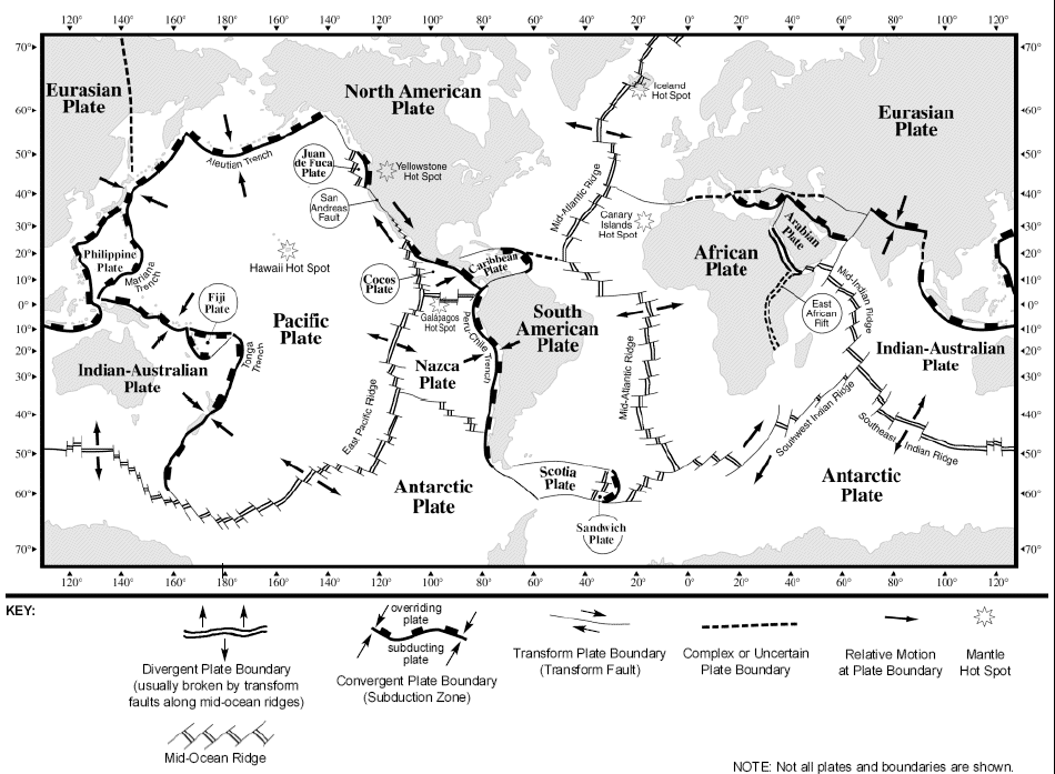
Earthquakes are a consequence geological processes flowing in the mantle and crust. Lithospheric plates move, and in normal situations this movement is barely noticeable. However, stress accumulates on crustal faults due to uneven movements, which ultimately causes earthquakes. These phenomena are not observed everywhere; they are characteristic of geologically turbulent places at the junctions of the earth's crust. The most unstable place is the so-called “ring of fire”, stretching along the outskirts of the Pacific Ocean. It frames the largest lithospheric plate on the planet, on which this ocean is located.
Related materials:
How has the Earth's surface changed?
Any, even the slightest, movement of such a mass of the earth’s crust cannot occur painlessly, so earthquakes occur constantly along its periphery. There is also massive volcanic activity there.
Predictions of earthquakes in the past

People have long sought to predict natural disasters. The first successful steps in this direction were made thousands of years ago in geologically turbulent regions. In China, ancient scientists were able to create an unusual vase, which was found by modern archaeologists during excavations. Ceramic dragons sit on the edge of the vase, each holding a ball in its mouth. At the slightest vibrations of the earth, harbingers of an impending earthquake, balls fell out of the mouths of the dragons - first of all, from the direction of the source of the future earthquake. This way people could find out in time about an imminent disaster, and even about which side the source of the cataclysm would be located.
Japan also had its own developments - this country has always been a turbulent place. Here people relied more on observations of nature. Before an earthquake, bottom fish rise to the upper layers of water; catfish show particular concern. This was noticed by fishermen, who each time in such cases hurried home to warn their loved ones about the impending disaster.
Related materials:
Why do earthquakes happen?
Interesting fact : Catfish in Japanese legends is seen as a fish symbolizing earth and stability. Perhaps this is due precisely to the fact that in a calm geological situation the fish swims peacefully and slowly at the bottom, and before earthquakes it begins to rush around and look for shelter.
It was also noted that the fire burning on a candle or splinter sharply goes down before earthquakes, and the candle burns out very quickly. This is due to geomagnetic changes that occur before a cataclysm. Also everywhere, people noted the anxiety of pets and their desire to leave the house before a disaster. Based on these and other signs, people of the past often managed to save themselves, their loved ones or property by leaving their homes and cities in time.
Modern methods of earthquake prediction

Today, seismographs are used to prevent earthquakes. These devices are particularly sensitive sensors that record any vibrations on the surface of the earth. Since microshocks are first observed before any earthquake, the device gives fairly accurate predictions. He records these warning signs and transmits the information to scientists, who warn people through the media. Today, every individual can have their own small seismograph at their disposal - there are individual seismic monitors on sale that record changes and transmit them within a network, which allows you to receive and send warnings.
Not a year goes by without a catastrophic earthquake happening somewhere, causing total destruction and casualties, the number of which can reach tens and hundreds of thousands. And then there is the tsunami - abnormally high waves that arise in the oceans after earthquakes and wash away villages and cities along with their inhabitants on the low shores. These disasters are always unexpected; their suddenness and unpredictability are frightening. Is modern science really unable to foresee such cataclysms? After all, they predict hurricanes, tornadoes, weather changes, floods, magnetic storms, even volcanic eruptions, but with earthquakes - complete failure. And society often believes that scientists are to blame. Thus, in Italy, six geophysicists and seismologists were put on trial for failing to predict the earthquake in L'Aquila in 2009, which claimed the lives of 300 people.
It would seem that there are many different instrumental methods, devices that record the slightest deformations of the earth's crust. But the earthquake forecast fails. So what's the deal? To answer this question, let's first consider what an earthquake is.
The uppermost shell of the Earth - the lithosphere, consisting of a solid crust with a thickness of 5–10 km in the oceans and up to 70 km under mountain ranges - is divided into a number of plates called lithospheric. Below is also the solid upper mantle, or rather, its top part. These geospheres consist of various rocks that have high hardness. But in the thickness of the upper mantle at different depths there is a layer called asthenospheric (from the Greek asthenos - weak), which has a lower viscosity compared to the above and underlying mantle rocks. It is assumed that the asthenosphere is the “lubricant” through which lithospheric plates and parts of the upper mantle can move.
During movement, the plates collide in some places, forming huge folded mountain chains, in others, on the contrary, they split to form oceans, the crust of which is heavier than the crust of the continents and is capable of sinking under them. These plate interactions cause enormous stress in rocks, compressing or, conversely, stretching them. When stresses exceed the tensile strength of rocks, they undergo very rapid, almost instantaneous displacement and rupture. The moment of this displacement constitutes an earthquake. If we want to predict it, we must give a forecast of place, time and possible strength.
Any earthquake is a process that occurs at a certain finite speed, with the formation and renewal of many different-scale ruptures, the ripping up of each of them with the release and redistribution of energy. At the same time, it is necessary to clearly understand that rocks are not a continuous homogeneous massif. It has cracks, structurally weakened zones, which significantly reduce its overall strength.
The speed of propagation of a rupture or ruptures reaches several kilometers per second, the destruction process covers a certain volume of rocks - the source of the earthquake. Its center is called the hypocenter, and its projection onto the Earth's surface is called the epicenter of the earthquake. Hypocenters are located at different depths. The deepest ones are up to 700 km, but often much less.
The intensity, or strength, of earthquakes, which is so important for forecasting, is characterized in points (a measure of destruction) on the MSK-64 scale: from 1 to 12, as well as magnitude M, a dimensionless value proposed by a professor at the Californian Institute of Technology C. F. Richter, which reflects the amount of released total energy of elastic vibrations.
What is a forecast?
To assess the possibility and practical usefulness of earthquake forecasting, it is necessary to clearly define what requirements it must meet. This is not a guess, not a trivial prediction obviously regular events. A forecast is defined as a scientifically based judgment about the place, time and state of a phenomenon, the patterns of occurrence, spread and change of which are unknown or unclear.
Fundamental predictability of seismic disasters long years there was no doubt. Belief in the limitless predictive potential of science was supported by seemingly quite convincing arguments. Seismic events with the release of enormous energy cannot occur in the bowels of the Earth without preparation. It should include certain restructuring of the structure and geophysical fields, the greater the more intense the expected earthquake. Manifestations of such restructuring - abnormal changes certain parameters of the geological environment are identified by methods of geological, geophysical and geodetic monitoring. The task, therefore, was to, having the necessary techniques and equipment, timely record the occurrence and development of such anomalies.
However, it turned out that even in areas where continuous careful observations are carried out - in California (USA), Japan - the strongest earthquakes happen unexpectedly every time. Get reliable and accurate forecast empirically it is not possible. The reason for this was seen in insufficient knowledge of the mechanism of the process under study.
Thus, the seismic process was considered a priori to be predictable in principle if the mechanisms, evidence and necessary techniques, unclear or insufficient today, are understood, supplemented and improved in the future. There are no fundamentally insurmountable obstacles to forecasting. Postulates inherited from classical science limitless possibilities scientific knowledge, prediction of processes of interest to us were, until relatively recently, the initial principles of any natural scientific research. How is this problem understood now?
It is quite obvious that even without special research it is possible to confidently “predict”, for example, a strong earthquake in the highly seismic zone of transition from the Asian continent to the Pacific Ocean in the next 1000 years. It can be just as “reasonably” stated that in the area of Iturup Island in the Kuril Ridge tomorrow at 14:00 Moscow time there will be an earthquake with a magnitude of 5.5. But the price for such forecasts is a pittance. The first of the forecasts is quite reliable, but no one needs it due to its extremely low accuracy; the second is quite accurate, but also useless, because its reliability is close to zero.
From this it is clear that: a) at any given level of knowledge, an increase in the reliability of the forecast entails a decrease in its accuracy, and vice versa; b) if the forecast accuracy of any two parameters (for example, the location and magnitude of an earthquake) is insufficient, even an accurate prediction of the third parameter (time) loses practical meaning.
Thus, the main task and main difficulty earthquake forecasting is that the predictions of its location, time and energy or intensity would satisfy the requirements of practice both in terms of accuracy and reliability. However, these requirements themselves vary depending not only on the achieved level of knowledge about earthquakes, but also on the specific forecasting goals that are met. different types forecast. It is customary to highlight:
- seismic zoning (seismicity estimates for decades - centuries);
- forecasts: long-term (for years - decades), medium-term (for months - years), short-term (in time 2-3 days - hours, in place 30-50 km) and sometimes operational (in hours - minutes).
The short-term forecast is especially relevant: it is this that is the basis for specific warnings about the upcoming disaster and for urgent actions to reduce the damage from it. The cost of mistakes here is very high. These errors are of two types:
- A “false alarm” is when, after taking all measures to minimize the number of casualties and material losses, the predicted strong earthquake does not occur.
- “Missing the target” when the earthquake that took place was not predicted. Such errors are extremely common: almost all catastrophic earthquakes are unexpected.
In the first case, the damage from disrupting the rhythm of life and work of thousands of people can be very large; in the second, the consequences are fraught not only with material losses, but also with human casualties. In both cases, the moral responsibility of seismologists for an incorrect forecast is very high. This forces them to be extremely careful when issuing (or not issuing) official warnings to the authorities about the impending danger. In turn, the authorities, realizing the enormous difficulties and dire consequences of stopping the functioning of a densely populated area or large city at least for a day or two, they are in no hurry to follow the recommendations of numerous “amateur” unofficial forecasters who declare 90% and even 100% reliability of their predictions.
The high price of ignorance
Meanwhile, the unpredictability of geocatastrophes is very costly for humanity. As Russian seismologist A.D. Zavyalov notes, for example, from 1965 to 1999 earthquakes accounted for 13% of the total natural disasters in the world. From 1900 to 1999, there were 2,000 earthquakes with a magnitude greater than 7. In 65 of them, M was greater than 8. Human losses from earthquakes in the 20th century amounted to 1.4 million people. Of these, in the last 30 years, when the number of victims began to be calculated more accurately, there were 987 thousand people, that is, 32.9 thousand people per year. Among all natural disasters, earthquakes rank third in terms of the number of deaths (17% of the total number of deaths). In Russia, on 25% of its area, where about 3,000 cities and towns, 100 large hydro and thermal power plants, and five nuclear power plants are located, seismic shocks with an intensity of 7 or more are possible. The strongest earthquakes in the twentieth century occurred in Kamchatka (November 4, 1952, M = 9.0), in the Aleutian Islands (March 9, 1957, M = 9.1), in Chile (May 22, 1960, M = 9.5 ), in Alaska (March 28, 1964, M = 9.2).
The list of major earthquakes in recent years is impressive.
2004, December 26. Sumatra-Andaman earthquake, M = 9.3. The strongest aftershock (repeated shock) with M = 7.5 occurred 3 hours 22 minutes after the main shock. In the first 24 hours after it, about 220 new earthquakes with M > 4.6 were registered. The tsunami hit the coasts of Sri Lanka, India, Indonesia, Thailand, Malaysia; 230 thousand people died. Three months later, an aftershock with M = 8.6 occurred.
2005, March 28. Nias Island, three kilometers from Sumatra, earthquake with M = 8.2. 1300 people died.
2005, October 8. Pakistan, earthquake with M = 7.6; 73 thousand people died, more three million were left homeless.
2006, May 27. Java Island, earthquake with M = 6.2; 6,618 people died, 647 thousand were left homeless.
2008, May 12. Sichuan Province, China, 92 km from Chengdu, earthquake M = 7.9; 87 thousand people were killed, 370 thousand were injured, 5 million were left homeless.
2009, April 6. Italy, earthquake with M = 5.8 near the historical city of L'Aquila; 300 people became victims, 1.5 thousand were injured, more than 50 thousand were left homeless.
2010, January 12. The island of Haiti, a few miles off the coast, two earthquakes with M = 7.0 and 5.9 within a few minutes. About 220 thousand people died.

2011, March 11. Japan, two earthquakes: M = 9.0, epicenter 373 km northeast of Tokyo; M = 7.1, epicenter 505 km northeast of Tokyo. Catastrophic tsunami, more than 13 thousand people died, 15.5 thousand went missing, destruction of the nuclear power plant. 30 minutes after the main shock - an aftershock with M = 7.9, then another shock with M = 7.7. During the first day after the earthquake, about 160 shocks with magnitudes from 4.6 to 7.1 were registered, of which 22 shocks with M > 6. During the second day, the number of registered aftershocks with M > 4.6 was about 130 (of which 7 aftershocks with M > 6.0). During the third day, this number dropped to 86 (including one shock with M = 6.0). On the 28th day, an earthquake with M = 7.1 occurred. By April 12, 940 aftershocks with M > 4.6 were recorded. The epicenters of the aftershocks covered an area about 650 km long and about 350 km across.

All, without exception, of the listed events turned out to be unexpected or “predicted” not so definitely and accurately that specific safety measures could be taken. Meanwhile, statements about the possibility and even repeated implementation of a reliable short-term forecast of specific earthquakes are not uncommon both on the pages of scientific publications and on the Internet.
A Tale of Two Forecasts
In the area of the city of Haicheng, Liaoning Province (China), in the early 70s of the last century, signs of a possible strong earthquake were repeatedly noted: changes in the slopes of the earth's surface, geomagnetic field, soil electrical resistance, water level in wells, and animal behavior. In January 1975, the impending danger was announced. By the beginning of February, the water level in the wells suddenly rose, and the number of weak earthquakes increased greatly. By the evening of February 3, the authorities were notified by seismologists of an imminent disaster. The next morning there was an earthquake with a magnitude of 4.7. At 14:00 it was announced that there was a possibility of even more strong blow. Residents left their homes and security measures were taken. At 19:36, a powerful shock (M = 7.3) caused widespread destruction, but there were few casualties.
This is the only example of a surprisingly accurate short-term forecast of a destructive earthquake in time, location and (approximately) intensity. However, other, very few forecasts that came true were insufficiently definite. The main thing is the number of both unpredicted real events, and false alarms remained extremely high. This meant that there was no reliable algorithm for stable and accurate prediction of seismic disasters, and the Haicheng forecast was most likely just an unusually successful coincidence of circumstances. Yes, a little more than a year later, in July 1976, an earthquake with M = 7.9 occurred 200–300 km east of Beijing. The city of Tangshan was completely destroyed, killing 250 thousand people. There were no specific harbingers of the disaster, and no alarm was declared.
After this, as well as after the failure of a long-term experiment to predict the earthquake in Parkfield (USA, California) in the mid-80s of the last century, skepticism prevailed about the prospects for solving the problem. This was reflected in most of the reports at the meeting “Evaluation of Earthquake Forecast Projects” in London (1996), held by the Royal Astronomical Society and the Joint Association of Geophysics, as well as in the discussion of seismologists from different countries on the pages of the journal "Nature"(February - April 1999).
Much later than the Tangshan earthquake, the Russian scientist A. A. Lyubushin, analyzing geophysical monitoring data of those years, was able to identify an anomaly that preceded this event (in the upper graph of Fig. 1 it is highlighted by the right vertical line). The anomaly corresponding to this catastrophe is also present in the lower, modified graph of the signal. Both graphs contain other anomalies that are not much worse than the one mentioned, but do not coincide with any earthquakes. But no harbinger of the Haicheng earthquake (left vertical line) was not initially found; the anomaly was revealed only after modifying the graph (Fig. 1, bottom). Thus, although it was possible to identify the precursors of the Tangshan and, to a lesser extent, Haicheng earthquakes a posteriori in this case, a reliable predictive identification of signs of future destructive events was not found.

Nowadays, analyzing the results of long-term, since 1997, continuous recordings of the microseismic background on Japanese islands, A. Lyubushin discovered that even six months before the strong earthquake on the island. Hokkaido (M = 8.3; September 25, 2003) there was a decrease in the time-average value of the precursor signal, after which the signal did not return to its previous level and stabilized at low values. Since mid-2002, this has been accompanied by an increase in the synchronization of the values of this characteristic across different stations. From the standpoint of catastrophe theory, such synchronization is a sign of the approaching transition of the system under study to a qualitatively new state, in this case an indication of an impending disaster. These and subsequent results of processing the available data led to the assumption that the event on the island. Hokkaido, although strong, is just a foreshock of an even more powerful upcoming catastrophe. So, in Fig. Figure 2 shows two anomalies in the behavior of the precursor signal - sharp minima in 2002 and 2009. Since the first of them was followed by an earthquake on September 25, 2003, the second minimum could be a harbinger of an even more powerful event with M = 8.5–9. Its place was indicated as “Japanese Islands”; it was more accurately determined retrospectively, after the fact. The time of the event was first predicted (April 2010) for July 2010, then from July 2010 for an indefinite period, which excluded the possibility of declaring an alarm. It happened on March 11, 2011, and, judging by Fig. 2, it could have been expected earlier and later.

This forecast refers to the medium-term ones, which have been successful before. Short-term successful forecasts are always rare: it was not possible to find any consistently effective set of precursors. And now there is no way to know in advance in what situations the same precursors will be effective as in A. Lyubushin’s forecast.
Lessons from the past, doubts and hopes for the future
What is it like current state problems of short-term seismic forecasting? The range of opinions is very wide.
In the last 50 years, attempts to predict the location and time of strong earthquakes within a few days have been unsuccessful. It was not possible to identify the precursors of specific earthquakes. Local disturbances of various environmental parameters cannot be precursors of individual earthquakes. It is possible that a short-term forecast with the required accuracy is generally unrealistic.
In September 2012, during the 33rd General Assembly European Seismological Commission (Moscow), general secretary International Association seismology and physics of the Earth's interior P. Sukhadolk admitted that breakthrough solutions in seismology are not expected in the near future. It was noted that none of the more than 600 known precursors and no set of them guarantee the prediction of earthquakes, which occur without precursors. It is not possible to confidently indicate the place, time, and power of the cataclysm. Hopes are pinned only on predictions where strong earthquakes occur with some frequency.
So is it possible in the future to increase both the accuracy and reliability of the forecast? Before looking for the answer, you should understand: why, in fact, should earthquakes be predictable? It is traditionally believed that any phenomenon is predictable if similar events that have already occurred are studied sufficiently fully, in detail and accurately, and forecasting can be built by analogy. But future events occur under conditions that are not identical to the previous ones, and therefore will certainly differ from them in some way. This approach can be effective if, as is implied, there are differences in the conditions for the origin and development of the process under study in different places, in different time are small and change its result in proportion to the magnitude of such differences, that is, also insignificantly. When such deviations are repeated, random, and have different meanings, they significantly cancel each other out, making it possible to ultimately obtain a not absolutely accurate, but statistically acceptable forecast. However, the possibility of such predictability was called into question at the end of the 20th century.
Pendulum and sand pile
It is known that the behavior of many natural systems is described quite satisfactorily by nonlinear differential equations. But their decisions at a certain critical point in evolution become unstable and ambiguous - the theoretical trajectory of development branches out. One or another of the branches is unpredictably realized under the influence of one of the many small random fluctuations that always occur in any system. It would be possible to predict the choice only with precise knowledge of the initial conditions. But nonlinear systems are very sensitive to their slightest changes. Because of this, choosing a path sequentially at only two or three branching points (bifurcations) leads to the fact that the behavior of solutions to completely deterministic equations turns out to be chaotic. This is expressed - even with a gradual increase in the values of any parameter, for example pressure - in the self-organization of collective irregular, abruptly rearranging movements and deformations of system elements and their aggregations. Such a regime, paradoxically combining determinism and chaos and defined as deterministic chaos, different from complete disorder, is by no means exceptional, and not only in nature. Let's give the simplest examples.
By squeezing a flexible ruler strictly along the longitudinal axis, we will not be able to predict in which direction it will bend. Swinging a frictionless pendulum so much that it reaches the point of the upper, unstable equilibrium position, but no more, we cannot predict whether the pendulum will go backwards or make a full revolution. Sending one billiard ball in the direction of another, we approximately foresee the trajectory of the latter, but after its collisions with the third, and even more so with the fourth ball, our predictions will turn out to be very inaccurate and unstable. By increasing a pile of sand with a uniform addition, when a certain critical angle of its slope is reached, we will see, along with the rolling of individual grains of sand, unpredictable avalanche-like collapses of spontaneously arising aggregations of grains. This is the deterministic-chaotic behavior of a system in a state of self-organized criticality. The patterns of mechanical behavior of individual sand grains are supplemented here with qualitatively new features determined by the internal connections of the aggregate of sand grains as a system.
In a fundamentally similar way, the discontinuous structure of rock masses is formed - from the initial dispersed microcracking to the growth of individual cracks, then to their interactions and interconnections. The rapid growth of a single, previously unpredictable disturbance among competing ones turns it into a major seismogenic rupture. In this process, each single act of rupture formation causes unpredictable rearrangements of the structure and stress state in the massif.
In the above and other similar examples, neither the final nor intermediate results of the nonlinear evolution determined by the initial conditions are predicted. This is not due to the influence of many factors that are difficult to take into account, nor to ignorance of the laws mechanical movement, but with the impossibility of estimating the initial conditions absolutely accurately. In these circumstances, even the slightest differences quickly push initially similar developmental trajectories as far apart as desired.
The traditional strategy for predicting disasters comes down to identifying a distinct precursor anomaly, generated, for example, by the concentration of stresses at the ends, kinks, and intersections of discontinuities. To become a reliable sign of an approaching shock, such an anomaly must be single and stand out in contrast against the surrounding background. But the real geoenvironment is structured differently. Under load, it behaves as a rough and self-similar block (fractal). This means that a block of any scale level contains relatively few blocks of smaller sizes, and each of them contains the same number of even smaller ones, etc. In such a structure there cannot be clearly isolated anomalies on a homogeneous background; it contains non-contrasting macro-, meso- and microanomalies.
This makes traditional tactics for solving the problem futile. Tracking the preparation of seismic disasters simultaneously in several relatively close locations potential danger foci reduces the likelihood of missing an event, but at the same time increases the likelihood of a false alarm, since the observed anomalies are not isolated and are not contrasted in the surrounding space. It is possible to foresee the deterministic-chaotic nature of the nonlinear process as a whole, its individual stages, and scenarios for the transition from stage to stage. But the required reliability and accuracy of short-term forecasts of specific events remain unattainable. The long-standing and almost universal belief that any unpredictability is only a consequence of insufficient knowledge and that with a more complete and detailed study, a complex, chaotic picture will certainly be replaced by a simpler one, and the forecast will become reliable, turned out to be an illusion.
The earth has one unfortunate property: it sometimes disappears from under one’s feet, and this is not always due to the results of a cheerful party in friendly circle. Ground shaking causes asphalt to stand on end and houses collapse. What's there at home?! — catastrophic earthquakes can uplift or destroy mountains, dry up lakes, and turn rivers around. In such situations, residents of houses, mountains and coasts have only one thing left to do: try to survive as best as possible.
People have been confronted with the violence of the earth's firmament approximately since the time when they descended onto this firmament from the trees. Apparently, the first attempts to explain the nature of earthquakes date back to the beginning of the human era, in which underground gods, demons and other pseudonyms of tectonic movements appear abundantly. As our ancestors acquired permanent housing with accompanying fortresses and chicken coops, the damage from shaking the ground beneath them became greater, and the desire to appease Vulcan, or at least predict his disfavor, became stronger.
However, different countries in ancient times they were shaken by various entities. The Japanese version gives the leading role to giant catfish living underground, which sometimes move. In March 2011, another fish riot led to a powerful earthquake and tsunami.
Scheme of tsunami propagation in the Pacific Ocean. The picture shows in color the height of the diverging different sides waves generated by an earthquake near Japan. Let us recall that the earthquake on March 11 brought down a tsunami wave on the coast of Japan, leading to the death of at least 20 thousand people, widespread destruction and the transformation of the word “Fukushima” into a synonym for Chernobyl. Responding to a tsunami requires great speed. The speed of ocean waves is measured in kilometers per hour, and seismic waves are measured in kilometers per second. Due to this, there is a time reserve of 10-15 minutes, during which it is necessary to notify the residents of the threatened area.
Unstable Firmament
The earth's crust is in very slow but continuous motion. Huge blocks press against each other and become deformed. When the stresses exceed the tensile strength, the deformation becomes inelastic - the earth's solids break, and the layers shift along the fault with elastic recoil. This theory was first proposed almost a hundred years ago by American geophysicist Harry Reid, who studied the 1906 earthquake that almost completely destroyed San Francisco. Since then, scientists have proposed many theories detailing the course of events in different ways, but the fundamental principle remains in general outline Same.
 The depth of the sea is variable. The arrival of a tsunami is often preceded by a retreat of water from the shore. Elastic deformations of the earth's crust preceding an earthquake leave water in place, but the depth of the bottom relative to sea level often changes. Monitoring sea depth is carried out by a network of special instruments - tide gauges, installed both on the shore and at a distance from the shore.
The variety of versions, alas, does not increase the volume of knowledge. It is known that the source (in scientific terms, the hypocenter) of an earthquake is an extended area in which the destruction of rocks occurs with the release of energy. Its volumes are directly related to the size of the hypocenter - the larger it is, the stronger the shaking. Outbreaks destructive earthquakes extend for tens and hundreds of kilometers. Thus, the source of the Kamchatka earthquake of 1952 had a length of about 500 km, and the Sumatran earthquake, which caused the worst in December 2004 modern history tsunami - at least 1300 km.
The dimensions of the hypocenter depend not only on the stresses accumulated in it, but also on the physical strength of the rocks. Each individual layer that finds itself in the destruction zone can either crack, increasing the scale of the event, or survive. The final result ultimately turns out to depend on many factors invisible from the surface.
 Tectonics in pictures. The collision of lithospheric plates leads to their deformation and stress accumulation.
Seismic climate
Seismic zoning of a territory makes it possible to predict the strength of possible tremors in a given location, even without indicating the exact location and time. The resulting map can be compared with a climate map, but instead of the atmospheric climate, it displays a seismic climate - an assessment of the possible strength of an earthquake in a given place.
The initial information is data on seismic activity in the past. Unfortunately, the history of instrumental observations of seismic processes goes back a little over a hundred years, and in many regions even less. Collecting data from historical sources: descriptions even by ancient authors are usually enough to determine the intensity of an earthquake, since the corresponding scales are built on the basis of everyday consequences - the destruction of buildings, the reaction of people, etc. But this, of course, is not enough - humanity is still too young. If in some region for last couple There hasn't been a magnitude 10 earthquake for thousands of years, but that doesn't mean it won't happen there next year. Bye we're talking about about ordinary low-rise construction, a risk of this level can be tolerated, but the placement of nuclear power plants, oil pipelines and other potentially dangerous objects clearly requires greater precision.
Similar articles
 The best amulets against the evil eye and damage Amulet against the evil eye with hands for children
-
The best amulets against the evil eye and damage Amulet against the evil eye with hands for children
-
The best amulets against the evil eye and damage Amulet against the evil eye with hands for children
 How to read the Psalter correctly
-
How to read the Psalter correctly
-
How to read the Psalter correctly
 Delicious dishes with sausages
 A glimpse of Bella. Romantic chronicle. A glimpse of genius. Messerer about Akhmadulina Boris Messerer glimpse of Bella romantic chronicle
 I dreamed that I was sailing on a boat on the river
 How to cook beef entrecote in a frying pan