
The largest rivers in Russia. the largest and longest rivers in Russia
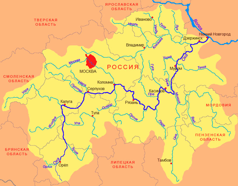
If you carefully study the map, the Oka River belongs to the right tributary of the Volga River. It begins with a source, which is located in Oryol region Russia. The river is characterized by a very winding topography, sometimes similar to peculiar loops. As you know, the Volga flows into the Caspian Sea. Therefore, the Oka River, like the Volga, is included in the basin of this sea.
The size of the river is 1,798 thousand meters and it occupies an area of 245 thousand km 2. Sometimes its width is at least 2.5 km.
The name of the river comes from the Finnish-Ugric dialect. "Iokki" translated means nothing more than "river". Some experts claim that Oka with Latin language translated in a similar way.
Starting from the Oryol region, r. The Oka still flows through some regions of the southwestern part of Russia. And directly:
- It originates in the Oryol region.
- Then it flows through the Kaluga region.
- Then through the Moscow region.
- Enters the Ryazan region.
- Will not bypass the Vladimir region.
- It ends in the Nizhny Novgorod region.
Oka is a significant transport source, especially for western regions Russia. Thus, the Oka River connects significant industrial, administrative, cultural and economic cities of Russia. It connects the following cities by waterway: Nizhny Novgorod, Orel, Kaluga, Murom and other equally important cities.

The river originates. Oka in the village of Aleksandrovka, Oryol region. It was put on maps back in the 80s of the 19th century. Starting from the spring, the river laid its course through the Central Russian Upland. At the initial path of the river there is a valley with deep slopes, which indicates a deeply indented topography. It begins its journey, heading north and along its path it merges with many channels. The Orlik River, flowing through the city of Orel, is considered the first tributary of the Oka River. They collide just in the city of Orel. The Upa River, which flows through the Tula region, is the second tributary of the Oka River. They merge together in the Tula region. In Kaluga, the Oka River connects with its third tributary, the Ugra River. After the confluence of these two rivers, the Oka River changes its course from north to east. After changing the direction of the channel, the river continues to flow along the Tula and Kaluga regions, meeting on its road such cities as Aleksin and Tarusa. Subsequently, the river is again redirected from east to north. Such changes in the direction of the river bed happen more than once, and after the river leaves the city of Aleksin, not far from the city of Protvino, the river will once again change its route from north to east.
Within the Moscow and Tula regions, the river is considered an element that conventionally separates these two areas. A similar border is observed within the cities of Serpukhov and Stupino. The next, fourth tributary of it is the river. Moscow. These two rivers merge within the city of Kolomka, Moscow region. After this, the Oka River sharply changes its route from east direction to the south. Within the lands of the Ryazan region, the Oka River is characterized by a rather winding route due to the highly hilly terrain. The Pronya River is considered the fifth tributary of this river. Having met the Pair River on its way, it is again redirected to the north. Carrying out a certain bend near the city of Kasimov, it returns to its original direction.
In the Ermishinsky district of the Ryazan region it meets its seventh tributary, the Mosha. After that, it flows along the border of the Nizhny Novgorod and Vladimir regions. The Klyazma River is considered the eighth and last tributary of the Oka River. They come together in the city of Pavlovo, Nizhny Novgorod region. On her way she meets the following cities: Murom, Pavlovo, Dzerzhinsk.
After this, in Nizhny Novgorod, the Oka River flows into the Volga River. This is where its mouth is located.

In the water register Russian Federation the Oka River was assigned the code 09010100112110000017555. Due to hydrological study, it was assigned the number 110001755,
Federal agency water resources assigned similar numbers based on information received from the geographic information system for water management zoning throughout the Russian Federation.
In addition, the Oka River has other codes, such as:
- 01.01.001 – code corresponding to the basin of this river.
- 10 – according to the volume number on GI.
- 0 – release according to GI.
Based on data received from the State Water Register of the Russian Federation:
- The river belongs to the Oka basin district.
- The area of the river from the source to the city of Orel corresponds to the status of national economic importance.
- The river sub-basin of a river is considered to be the basins of the river's tributaries up to its confluence with the Moksha River.
- The river basin is represented by the Oka River.
Water resources of the river basin Eyes are used in shipping.
The following authorities regulate this process:
- The Volzhskoe State Budgetary Institution is a segment from the mouth of the Oka River to the Seima River canal.
- FSUE “Canal named after. Moscow" - the section from the Seima River to the city of Kaluga.

The Oka River serves as part of the most important transport connection for various cities of the Russian Federation. It is considered one of the main water transport routes of the state. It seems to connect many towns, cities and villages into one whole. Throughout almost the entire route, a considerable number of both large and small rivers, as well as small rivulets, flow into the Oka River. This number reaches 100, or even more. The key large and medium-sized rivers, which are tributaries (the basin area reaches 50 thousand km2), are considered:
Left tributaries (from the mouth to the Oka River):
- R. Klyazma - 87.0 thousand sq. m.;
- R. Seimas - 58.0 thousand square meters;
- R. Chucha - 145.0 thousand square meters;
- R. Visha - 152.0 thousand sq.m.;
- R. Mothra - 186.0 thousand sq.m.;
- R. Ushna - 191.0 thousand sq.m.;
- R. Vershinskaya - 227.0 thousand sq. m.;
- R. Salka - 261.0 thousand sq.m.;
- R. Unzha - 322.0 thousand sq.m.;
- R. Goose - 426.0 thousand sq.m.;
- R. Pra - 479.0 thousand sq.m.;
- R. Moscow - 855.0 thousand sq.m.;
- R. Kremichenka - 925.0 thousand sq.m.;
- R. Nara - 979.0 thousand sq. m.;
- R. Protva - 990.0 thousand sq.m.;
- R. Tarusa - 1006.0 thousand square meters;
- R. Dryasha - 1025.0 thousand sq.m.;
- R. Ugra - 1122.0 thousand sq.m.;
- R. Zhizdra - 1164.0 thousand square meters;
- R. Tsvetyn – 1370.0 thousand sq.m.
Right tributaries (from the mouth to the Oka River):
- R. Kishma - 103.0 thousand sq.m.;
- R. Helmet - 108.0 thousand sq.m.;
- R. Kuzoma - 123.0 thousand sq.m.;
- R. Tesha - 204.0 thousand sq.m.;
- R. Veletma - 206.0 thousand sq.m.;
- R. Zheleznitsa - 251.0 thousand sq. m;
- R. Maulinka - 293.0 thousand square meters;
- R. Pra - 556.0 thousand square meters;
- R. Pronya - 615.0 thousand sq.m.;
- R. Raka - 658.0 thousand sq.m.;
- R. Besputa - 940.0 thousand square meters;
- R. Ochka - 1494.0 thousand sq.m.;
- R. Ore - 1475.0 thousand sq.m.;
- R. Knubr - 1411.0 thousand square meters;
- R. Zusha - 1303.0 thousand square meters;
- R. Vypreyka - 101.0 thousand sq.m.;
- R. Gilt - 1043.0 thousand sq.m.;
- R. Pytal - 1050.0 thousand sq.m.;
- R. UPA - 1302.0 thousand sq.m.;
- R. Svoboda - 1178.0 thousand sq.m.;
- R. Muzhach - 1142.0 thousand sq. m.

More than thirty bridges were built across the Oka River at various times. These include railway, automobile and pontoon crossings, not counting other, less important crossings across the Oka River.
The most important bridges are:
- Kanavinsky, which is located in Nizhny Novgorod. This bridge reaches 795 m in length and 23 m in width. It was erected in the 30s of the last century.
- Nizhny Novgorod metro bridge, located in Nizhny Novgorod and has 1 km 230 m in length, width - 18 m and this bridge was built in 2012.
- Molitovsky Bridge is also located in Nizhny Novgorod. It is 951 m long and 21 m wide. This bridge was built in the 90s of the last century.
- Myzinsky also has a residence permit in Nizhny Novgorod. It is 1 km long and 27 m wide, commissioned in the 80s of the last century. It is an important junction on Route No. 7.
- Sartakovsky Bridge has a railway purpose and began its work in the 60s of the 20th century.
- The Pavlovsky pontoon bridge has been functioning in the same way since the 60s of the 20th century and is 323 meters long and 7 meters wide.
- Kashira railway bridge. It was put into operation in the 30s of the last century and is 580 meters long.
- The Red Bridge has been in operation since the 50s of the 20th century and is located in the city of Orel.
- The Striginsky Bridge has been in operation since 1993. It is 950 m long and is an important element of route No. 7.
- Muromsky Bridge was inaugurated in 2009. It is 1 km 393 m long and 15 m wide.
Flora and fauna of the Oka River
The basin of this river covers a vast area and it flows through several areas, which is believed to be the reason for the presence of all kinds of animals and plants. In addition to various settlements, the river bed passes through broad-leaved plantations, namely through Eastern European forests, where pedunculate oaks are considered the main representatives. Except deciduous forests You can also find conifers, with the presence of spruce and pine trees.
The following interesting plants grow within the Oka River:
- brilliant pondweed;
- narrow-leaved pondweed;
- curly pondweed;
- teloresis;
- hornwort;
- yellow egg capsule;
- watercolor;
- duckweed;
- reed;
- water manna;
- common arrowhead.
It is quite natural that this is not full list and in the Oka River you can find a number of other, no less common plants.

The river bed passes through a number of large industrial centers, where it is seriously polluted by both industrial and wastewater. It is quite natural that this causes serious blow on the life activity of animals and plants, including the presence of fish species. Despite this, some areas of the river are quite different clean water, especially after its merger with the river. Moscow. And this factor makes its own adjustments to the composition of flora and fauna. In places where there is pure water observed wide range availability of fish resources, which, in turn, attracts fishermen.
In addition, there are many bays in the river basin, which has a beneficial effect on reproduction various types fish
With the onset of spring, somewhere in late April, early May, the fish go to spawn, choosing their favorite places. As spring begins to take hold, many anglers begin summer period fishing. Winter season for fishing enthusiasts it opens with the beginning of the first freeze-up, when the ice reaches a certain safe thickness.
Pike, as a rule, is well caught in the spring, during the pre-spawning period and in the fall, starting from the end of August. Bream can be caught all year round. In the Oka River you can hunt for real river monster– catfish.
On detailed map Russia can be considered in the smallest details cities, towns, villages of Russia. The map of Russia shows seas, bays, rivers, lakes and canals. The map allows you to zoom out or zoom in as you wish. In satellite mode, the map of Russia allows you to see your home from a bird's eye view.
Moscow on a detailed map of Russia
Moscow is the capital of the Russian Federation, the largest city in Russia. The detailed map of Russia shows streets, avenues, alleys, boulevards and squares in Russian. All houses are numbered on the map. The map of Moscow shows one-way streets. A detailed map of Russia allows you to find museums, theaters, cafes, restaurants, shops, monuments, railway ticket offices, airline ticket offices, banks (ATMs). The map of Russia shows public transport stops in the city of Moscow and stations of the Moscow metro (metro).
Google Street View on the map of Russia in Moscow
The Google Street View service allows you to view street panoramas. Using this service you can clearly see the panorama of a specific place. A panorama on a map of Moscow allows you to better navigate Moscow and quickly find the desired location (after “looking” at it on a detailed map of Russia). The panorama is created using a car equipped with photographic equipment that takes photographs of the panorama over a certain distance. The camera is installed on the car at a height of 2.5 meters. If the photo contains people's faces or car license plates, the program erases them so that they are illegible (cloudy).
St. Petersburg on a detailed map of Russia
St. Petersburg is the second largest city in Russia. The detailed map of Russia shows the streets, avenues, boulevards, alleys and squares of the city in Russian. All houses indicated on the map are numbered. The detailed map of St. Petersburg shows public transport stops and metro stations. Using the map of Russia you can easily find museums, theaters, monuments, shops, restaurants, cafes, banks and ATMs and other attractions of St. Petersburg.
Sochi on a detailed map of Russia
The city of Sochi is a Russian resort located on the Black Sea coast. In 2014, the city hosted the Olympic Games. Here are the Olympic venues in the Olympic Park: Fisht Stadium, Big Ice Stadium, Shayba Ice Stadium, Iceberg Stadium, Adler Arena and others. A detailed map of Russia shows all the streets, avenues and squares of the city of Sochi. Sochi is divided into four administrative districts: Central, Khostinsky, Adlersky, Lazarevsky. The detailed map of Russia shows the railway stations of Sochi: Olympic Village, Olympic Park, Adler. The map shows Sochi International Airport.
Rivers, lakes on a detailed map of Russia
Rivers on the map of Russia
The detailed map of Russia shows the major rivers of Russia: Volga, Ob, Amur, Lena, Neva, Yenisei, Irtysh, Ural and other rivers. The scale of the detailed map of Russia is such that it allows you to see very small rivers in Russia. For example, in the Tver region, in the upper reaches of the Volga River, in the Selizharovsky district, you can examine in detail very small rivers: Bolshaya and Malaya Kosha (river width 5 meters). In the Moscow region, you can examine in detail a tributary of the Moscow River - the Bykovka River. The map shows bridges and river crossings, piers and piers.
Lakes on the map of Russia
The detailed map of Russia shows the following lakes: Baikal, Ladoga, Ilmen, Seliger, Lake Peipus-Pskov, Caspian Sea, Chany, Sartlan, Ubinskoye, Chukchagirskoye, Gusinoye and many other lakes in Russia. The map in satellite mode allows you to view in detail the berths and ports on the lakes.
Cities on a detailed map of Russia
The detailed map of Russia shows the cities of Russia: Moscow (the capital of the Russian Federation), St. Petersburg, Novosibirsk, Barnaul, Samara, Volgograd, Sochi, Krasnodar, Khabarovsk, Omsk, Vladivostok, Komsomolsk-on-Amur, Novgorod, Pskov, Rostov-on-Don -Don, Magnitogorsk, Chita, Krasnoyarsk, Vladimir, Tula and other cities of Russia. The map of Russia shows small towns of regional significance: Udomlya and Ostashkov (Tver region), Opochka (Pskov region), Essentuki ( Stavropol region), Anapa ( Krasnodar region), Zelenogorsk (Leningrad region).
Russia is located in eastern Europe and northern Asia, occupying about 1/3 of the territory of Eurasia and 1/9 of the earth's landmass. The European part of the country (about 23% of the area) includes territories west of the Ural Mountains (the border is conventionally drawn along the Urals and the Kuma-Manych depression); The Asian part of Russia, occupying about 76% of the territory, lies east of the Urals and is also called Siberia (however precise definition borders of Siberia is a controversial issue) and the Far East. The total length of Russia's borders is 60,933 km (of which 38,808 km are maritime boundaries); Russia's borders in the north and east are maritime, in the south and west they are mainly land. Despite the fact that Russia is the largest in terms of area largest country world, climatic and soil conditions in most of its territory are not conducive to Agriculture.
Russia is one of the most water-rich countries in the world. The country has some of the world's largest reserves fresh water. Surface waters occupy 12.4% of Russia's territory, with 84% of surface waters concentrated east of the Urals; Many densely populated areas of the European part of Russia experience a shortage of water resources. The structure of water use is dominated by industrial needs.
Russia is home to the deepest lake in the world (Baikal), the longest river in Europe (Volga) and largest lake Europe (Ladoga), pole of cold Northern Hemisphere(Verkhoyansk), as well as the highest peak in Europe (Elbrus) (when drawing the border between Europe and Asia along the Greater Caucasus Range, and not along the Kuma and Manych rivers to the mouth of the Don).

Lakes of Russia.
There are over 2.5 million lakes in Russia. The largest lakes are the Caspian, Ladoga, Onega, and Baikal. The Caspian Sea is the largest lake in the world by area, and the deepest is Lake Baikal. The lakes are distributed very unevenly. There are especially many of them in the Vilyui depression, on West Siberian Plains e and in the north-west of the European Plain - in Karelia. All these areas are in conditions of excessive moisture. To the south, in the zone of steppes and semi-deserts with their arid climate, the number of lakes decreases sharply, and many lakes have salty or brackish water. Such large drainless lakes as the Caspian Sea, as well as lakes Elton and Baskunchak, where table salt is mined, are salty.
There are also countless smaller lakes, located mainly in the poorly drained lowlands of the Russian and West Siberian plains, especially in the more northern regions. Some of them reach significant sizes, in particular, Lake Beloe (1.29 thousand sq. km.), Topozero (0.98 thousand sq. km.), Vygozero (0.56 thousand sq. km.) and Lake Ilmen (0.98 thousand sq. km.) in the European northwest of the country, and Lake Chany (1.4-2 thousand sq. km.) in the southwest of Siberia.
Lakes also differ in the origin of their basins. Lakes of tectonic origin are located in troughs and depressions earth's crust. The largest tectonic Lake Baikal is located in a graben and therefore reaches a depth of 1637 m.
Glacial-tectonic lake basins arose as a result of glacier processing of tectonic depressions of the earth's crust: Imandra, Ladoga, Onega. In Kamchatka and the Kuril Islands, lakes are mainly of volcanic origin. In the north-west of the European Plain, the origin of lake basins is associated with continental glaciations. Many basins are located between moraine hills: Seliger, Valdai.
As a result of landslides in mountain valleys, dammed lakes appeared: Sarez in the Pamirs, Ritsa in the Caucasus. Small lakes appear above karst sinkholes. On South Western Siberia many saucer-shaped lakes that arose as a result of subsidence of loose rocks. When ice melts in areas of permafrost, saucer-shaped shallow lakes also form. Oxbow lakes are located on floodplains lowland rivers. There are estuary lakes along the shores of the Black and Azov Seas.
All large and largest lakes Russia are widely used in the national economy. They catch and raise fish there. Especially a lot of fish, including the most valuable sturgeon, are caught in the Caspian Sea. There is an omul fishery in Baikal. The lakes are also used for shipping. A variety of minerals are mined in the basins of the lakes: oil and mirabilite in the Caspian Sea, table salt in Elton and Baskunchak.
The largest lakes in Russia.
Caspian Sea, area - 376,000 sq. km., greatest depth- 1,025 meters.
Lake Baikal, area - 31,500 sq. km., greatest depth - 1,620 meters.
Lake Ladoga, area - 17,700 sq. km., greatest depth - 230 meters.
Lake Onega, area - 9,690 sq. km., greatest depth - 127 meters.
Taimyr lakes, area - 4,560 sq. km., greatest depth - 26 meters.
Lake Khanka, area - 4,190 sq. km., greatest depth - 11 meters.
Lake Peipus-Pskov, area - 3,550 sq. km., greatest depth - 15 meters.
Lake Chany, area - 1,708-2,269 sq. km., greatest depth - up to 10 meters.
White Lake, area - 1,290 sq. km., greatest depth - 6 meters.
Topozero, area - 986 sq. km., greatest depth - 56 meters.
Lake Ilmen, area - 982 sq. km., greatest depth - up to 10 meters.
Lake Imandra, area - 876 sq. km., greatest depth - 67 meters.
Khantayskoye Lake, area - 822 sq. km., greatest depth - 420 meters.
Segozero, area - 815 sq. km., greatest depth - 97 meters.
Kulundinskoye Lake, area - 728 sq. km., greatest depth - 4 meters.
Lake Teletskoye, area - 223 sq. km., greatest depth - 325 meters.


Rivers of Russia.
Russia occupies a vast geographical area, and it is not surprising that numerous rivers stretch across its expanses, which played an important historical role in the settlement and development of new lands. Almost everything is located on rivers Largest cities countries. Within Russia there are about 3 million rivers with a total length of almost 10 million km. Most of the rivers in Russia belong to the Arctic Ocean basin. It makes up over 66% of the country’s area; up to 80% falls within its borders. atmospheric precipitation. The rivers flowing into the northern seas are the longest and deepest in Russia. The longest river is Lena - 4400 km. The most deep river- Yenisei (623 km3 per year). In terms of drainage area, the Ob River ranks first in the country (2975 sq. km.). The rivers of the Arctic Ocean basin are freezing. In winter, a winter road is installed along them for about four months - roads for the movement of cars and sleighs.
The largest rivers of Siberia originate in the south of the country in the Altai, Sayan and Baikal mountains. The rivers of the Arctic Ocean basin are fed by snow and rain. In the spring, due to the melting of snow on the rivers, water rises. The flood begins in the south, and in the north the ice for a long time prevents the flow of melt water to the ocean. Therefore, in all rivers of the Arctic Ocean basin, high water rises occur in the middle and lower reaches in the spring. IN southern parts The rivers of Siberia are swift and rapid. On these segments of the valleys, large hydroelectric power stations have been built and are being built: Krasnoyarsk and Sayano-Shushenskaya on the Yenisei, Novosibirsk on the Ob, Bukhtarminsk and Ust-Kamenogorsk on the Irtysh, Irkutsk, Bratsk and Ust-Ilimsk on the Angara, on the tributaries of the Lena - Vilyue and Vitim - Vilyuiskaya was built and Mamakan hydroelectric station. On the northern plains, the flow of these rivers is calm and smooth. In summer they are used for timber rafting and shipping, connecting the southern and inland regions of the country with the Northern Sea Route and the Trans-Siberian Railway.
The rivers of the European part of the Arctic Ocean basin - Pechora, Mezen, Northern Dvina and Onega - are much shorter than Siberian rivers. They flow entirely across the plains and therefore have a calm current.
To the pool Pacific Ocean covers approximately 19% of the country's area. The main river of this basin is the Amur and its tributaries Zeya, Bureya and Ussuri. Rivers have predominantly rain power. In the monsoon climate in the Pacific Ocean there is little snow in winter, so there are no spring floods, but there are very significant floods due to summer monsoon rains. The water in the Amur and its tributaries rises by 10-15 m and floods vast areas. Catastrophic spills usually occur in early autumn. At this time, the Far Eastern regions of the country are often hit by sudden and violent downpours of cyclones - typhoons. River floods reach several tens of kilometers and cause enormous damage to agriculture, cities and towns.
The Amur and its tributaries have a large fall and are rich in hydroelectric power. The Zeya hydroelectric power station was built on the Zeya River. Amur - the main river highway Far East, which communicates internal remote areas with the seas. The Russian state border with the Argun, Amur and Ussuri rivers People's Republic China.
The rivers of Chukotka and the Sea of Okhotsk basin are predominantly fed by snow. Therefore, they are full of water in late spring and early summer, which is favorable for movement salmon fish, rising up rivers and streams to spawn.
The Caspian basin is called endorheic, since the rivers carry their waters not into the World Ocean, but into an internal endorheic reservoir - the Caspian Sea. The basin covers the interior of the East European Plain, Southern Urals, eastern part of the Caucasus.
The rivers Volga, Ural, Araks, Terek, Emba and others flow into the Caspian Sea. The largest river is the Volga. Its basin occupies 34% of the East European Plain. Most of the Volga's tributaries are located in a temperate continental climate with sufficient moisture. The food is predominantly snowy. In the spring, when the snow melts, there is a significant rise in water in the river. In summer the main source of power is The groundwater and rains. Some rise in water in the riverbed also occurs in autumn, when evaporation decreases significantly. Below the mouth of the large left tributary of the Kama, the Volga flows through the steppe and semi-desert zone, where there is very little precipitation and therefore no significant inflows. Below Volgograd, the Volga has no tributaries and is of a transit nature. It only carries water and partially evaporates it. From here the Volga breaks up into branches, the largest of which is Akhtuba. Below Astrakhan, the channel is divided into 80 branches, forming a vast delta. Nowadays, almost the entire Volga has turned into a cascade of dams and reservoirs. On the Upper Volga near Tver there is the Ivankovskoye Reservoir. The channel named after him begins from here. Moscow, through which Volga water is pumped for water supply to Moscow. Below, the entire Volga to Volgograd has turned into a chain of interconnected reservoirs (Uglichskoye, Rybinskoye, Gorkovskoye, Cheboksary, Kuibyshevskoye, Saratovskoye and Volgogradskoye). They retain a significant part of the spring flood water, which is used to generate electricity, supply water to cities, and irrigate dry lands. Thanks to reservoirs, the movement of large river vessels is possible. Nowadays the river is connected by the Volga-Don shipping canal with the Black and Azov seas, and the Volga-Baltic with the Baltic and White seas. Half of all river cargo and passengers in the country are transported along the Volga. But the reservoirs were flooded large areas fertile floodplain lands. The dams led to a slowdown in the flow of the Volga. As a result, large amounts of pollutants began to accumulate in reservoirs, which come from fields, as well as from industrial and domestic wastewater. Therefore, the river is currently heavily polluted.
Pool Atlantic Ocean occupies the smallest area - about 5% of the entire territory of Russia. The rivers flow west into the Baltic Sea and south into the Black and Azov Seas. The Western Dvina, Neman, Neva and others flow to the west. To the south - the Dnieper, Don and Kuban. All rivers of the Atlantic Ocean basin are deep all year round, since most of their watersheds are located in areas of sufficient moisture. They feed primarily on snow, and in summer - underground and rain. For rivers flowing into the Baltic Sea, flow fluctuations are very small, since precipitation falls evenly throughout the year. Only small spring floods and autumn floods are observed. The Neva River occupies a special place. This short river(74 km long) carries a huge amount of water - 79.7 km3 per year, four times more than the Dnieper, which has a length of over 2 thousand km. The Neva originates in Lake Ladoga and therefore its flow is constant throughout the year.
But almost every year it floods part of St. Petersburg with its waters. Floods are caused by surges of water from Baltic Sea, which gird the Neva. As a result, the water in the river rises by 2 - 3.5 m and splashes out from the granite embankments onto the streets and squares of the city.
The rivers of the southern Atlantic basin receive water in their branched upper reaches. In the lower sections they are of a transit nature, since here the rivers cross the steppe zone with an arid climate. The Dnieper and Don are predominantly fed by snow, which is why they experience high spring floods. On southern rivers a cascade of waterworks and reservoirs was built. The reservoirs are used both to generate electricity and to irrigate the arid lands of the southern East European Plain. In the Azov region and the Northern Caucasus, thanks to the waters of the Don and Kuban, rice and other agricultural crops are grown.
The largest rivers in Russia.
Lena, length - 4320 km, basin area - 2418 thousand sq. km.
Yenisei (with Biy-Khem), length - 4012 km, basin area - 2707 thousand sq. km.
Ob (with Katun), length - 4070 km, basin area - 2425 thousand sq. km.
Volga, length - 3690 km, basin area - 1380 thousand sq. km.
Amur, length - 2824 km, basin area - 1855 thousand sq. km.
Ural, length - 2530 km, basin area - 220 thousand sq. km.
Kolyma, length - 2150 km, basin area - 644 thousand sq. km.
Don, length - 1950 km, basin area - 422 thousand sq. km.
Indigirka, length - 1790 km, basin area - 360 thousand sq. km.
Pechora, length - 1790 km, basin area - 327 thousand sq. km.
Northern Dvina (with Sukhona), length - 1300 km, basin area - 411 thousand sq. km.
Yana (with Dulgalakh), length - 1070 km, basin area - 318 thousand sq. km.
Selenga (with Ider), length - 1020 km, basin area - 445 thousand sq. km.
Mezen, length - 966 km, basin area - 76 thousand sq. km.
Kuban, length - 906 km, basin area - 51 thousand sq. km.
Terek, length - 626 km, basin area - 44 thousand sq. km.
Onega, length - 416 km, basin area - 58 thousand sq. km.
Neva, length - 74 km, basin area - 282 thousand sq. km.
, which you will meet on your way when driving along the highway Chernaya Rechka village - Moscow. The route Chernaya Rechka-Moscow village proposed on the schematic map is only one of the possible ones. You can make your way through any transit point you choose. To get detailed information about settlements, forks, bridges, railway tracks and other objects on your way, you can use various functions, such as zooming in/out, switching layers (satellite, diagram, hybrid, folk map). Using the "ruler" function, you can determine the straight line distance to any point on the map. Some motorists prefer to use maps printed on paper. To print the route map, click on the "Print route" button.
Russia occupies a vast geographical area, and it is not surprising that numerous rivers stretch across its expanses, which played an important historical role in the settlement and development of new lands. Almost all the largest cities in the country are located on rivers.
In total, there are about 3 million rivers on the territory of the Russian Federation, and all of them are an important component of the life of many people, animals and plants. Rivers provide us with food, water, electricity, places for recreation, and also serve as transport routes connecting different settlements. It is an indispensable source of water for agriculture and industry. In this article you can get acquainted with the largest rivers of Russia, get them brief description and to look geographical location
on the map of the country.
Map of the largest rivers in Russia
The country's territory is divided into European and Asian parts. The dividing line is usually considered to be the Ural Mountains and the Caspian Sea. The rivers of the European part flow into the Arctic Ocean, the Baltic Sea, the Black Sea and the Caspian Sea. The rivers of the Asian part flow into the Arctic and Pacific oceans.
The largest rivers in European Russia are the Volga, Don, Kama, Oka and Northern Dvina, while some rivers originate in Russia but flow into other countries, such as the Dnieper and Western Dvina. The following large rivers flow through the Asian expanses of the country: Ob, Irtysh, Yenisei, Angara, Lena, Yana, Indigirka and Kolyma.
Of the five main drainage basins: Arctic, Pacific, Baltic, Black Sea and Caspian, the first, located in Siberia and including the northern part of the Russian Plain, is the most extensive. IN to a greater extent, this basin is filled by the three largest rivers in Russia: the Ob (3650 km), which, together with its main tributary, the Irtysh River, forms a river system 5410 km long, the Yenisei (3487 km), and the Lena (4400 km). The sum of their drainage areas exceeds 8 million km², and the total water flow is about 50,000 m³/s.
Siberia's major rivers provide transport arteries inland to the Arctic Sea Route, although they are blocked by ice for long periods each year. The slight slope of the Ob River causes it to slowly meander through a huge floodplain. Due to the flow to the north, from the upper reaches to the lower boundaries of the thaw, extensive flooding occurs quite often, which leads to the development of huge swamps. The Vasyugan swamps on the Ob-Irtysh interfluve cover an area of more than 50,000 km².
The rivers of the rest of Siberia (about 4.7 million km²) flow into the Pacific Ocean. In the north, where the watershed is close to the coast, numerous small, fast-flowing streams flow from the mountains, but most of southeastern Siberia is drained by the Amur River. For most of its length, the Amur forms the border separating Russia and China. The Ussuri, one of the tributaries of the Amur, forms another significant border line between the countries.
Three large drainage basins are located in European Russia south of the Arctic Basin. The Dnieper, only the upper reaches of which are in Russia, as well as the Don and Volga are the longest European river, originating in the north-west of the Valdai Hills and flowing into the Caspian Sea. Second only to the Siberian rivers, the Volga basin covers an area of 1,380,000 km². The rivers of the East European Plain have long served as important transport arteries; in fact, the Volga river system provides two-thirds of the entire Russian inland waterway traffic.
10 largest and longest rivers in Russia
Many mighty rivers flow through the territory of the Russian Federation, but the size of some of them is truly impressive. Below is a list and maps of the country's largest rivers, both by length and by drainage basin area.
Lena

 The Lena River is one of the most long rivers planets. It originates near Lake Baikal in southern Russia and flows west, and then above Yakutsk it smoothly turns north, where it flows into the Laptev Sea (a basin of the Arctic Ocean). Near the mouth, the river forms huge delta with an area of 32,000 km, which is the largest in the Arctic and the most extensive protected wilderness area in Russia.
The Lena Delta, which floods every spring, serves as an important area for nesting and migration of birds, and also supports rich fish populations. The river is home to 92 planktonic species, 57 benthos species and 38 fish species. Sturgeon, burbot, chum salmon, whitefish, nelma and albula are the most commercially important fish species.
Swans, dippers, geese, ducks, plovers, waders, snipe, phalaropes, terns, skuas, predator birds, sparrows and gulls are just some of the migratory birds that nest in the Lena's productive wetlands.
Ob

 The Ob is the seventh longest river in the world, stretching over a distance of 3,650 kilometers in the Western Siberian region of the Russian Federation. This river, which is of great economic importance for Russia, arises at the confluence of the Biya and Katun rivers in Altai. It mainly passes through the country, although many of its tributaries originate in China, Mongolia and Kazakhstan. Ob connects with its largest influx Irtysh River, about 69° east longitude. It flows into the Kara Sea of the Arctic Ocean, forming the Ob Bay. The river has a huge drainage area, which is about 2.99 million km².
The habitat surrounding the Ob consists of vast expanses of steppe and taiga flora in the upper and middle reaches of the river. Birches, pines, firs and cedars are some of the famous trees growing in these areas. Thickets of willow, rose hips and bird cherry also grow along the watercourse. The river basin is replete with aquatic flora and fauna, including more than 50 species of fish (sturgeon, carp, perch, nelma and peled, etc.) and about 150 species of birds. Minks, wolves, Siberian moles, otters, beavers, stoats and other local mammal species. In the lower reaches of the Ob, arctic tundra, is characterized by snow-covered landscapes for most of the year. Polar bears, arctic foxes, polar owls and arctic hares represent this region.
Volga
 The longest river in Europe, the Volga, which is often considered the national river of Russia, has large swimming pool, covering almost two-thirds of the European part of Russia. The Volga originates in the north-west of the Valdai Hills, and flows south over 3530 km, where it flows into the Caspian Sea. About 200 tributaries join the river along the entire route. Eleven of the country's major cities, including Moscow, are located along the Volga basin, which covers an area of 1.36 million km².
The climate in the river basin varies along its course from north to south. In the northern regions it predominates temperate climate with cold snowy winters and warm humid summers. The southern regions are characterized by cool winters and hot, dry summers. The Volga Delta is one of the richest habitats, which is home to 430 plant species, 127 fish species, 260 bird species and 850 aquatic species.
Yenisei

 The mouth of the Yenisei River is located near the city of Kazyl, where it merges with the Little Yenisei River, which originates in Mongolia and flows north, where it drains a vast area of Siberia before emptying into the Kara Sea (Arctic Ocean), a journey of 3,487 km. The Angara River, which flows from Lake Baikal, is one of the main tributaries of the upper Yenisei.
The waters of the Yenisei are home to about 55 species of local fish, including Siberian sturgeon, flounder, roach, northern pike, Siberian gudgeon, tench and sterlet. Most of the river basin surrounds, mainly consisting of the following rocks coniferous trees: fir, cedar, pine and larch. In some areas of the upper Yenisei there are also steppe pastures. In the north, boreal forests give way to arctic forests. Musk deer, elk, roe deer and Japanese mouse- some species of mammals living in taiga forests along the river. Also found are birds such as the Siberian blue robin, Siberian lentil, capercaillie and wood snipe. Ducks, geese and swans are found in the lower reaches in the summer.
Lower Tunguska

 The Lower Tunguska is a right tributary of the Yenisei, flowing through Irkutsk region And Krasnoyarsk region Russia. Its length is 2989 km, and the basin area is 473 thousand km². The river extends near the watershed between the Yenisei and Lena river basins and flows north and then west across the Central Siberian Plateau.
In the upper reaches the river forms a wide valley with numerous shallows, but after turning to the west the valley narrows and numerous gorges and rapids appear. In the river basin lies the vast Tunguska coal basin.
Amur

 The Amur is the tenth longest river in the world, located in East Asia and forms the border between the Far Eastern District of the Russian Federation and Northeast China. The river originates at the confluence of the Shilka and Argun rivers. The Amur flows for 2825 km to the northwestern part of the Pacific Ocean and flows into the Sea of Okhotsk.
The river has many vegetation zones in various parts of its basin, including taiga forests and swamps, Manchurian mixed forests, Amur meadow steppes, forest-steppes, steppes and tundra. The wetlands along the Amur basin are some of the most valuable ecosystems, home to a huge variety of flora and fauna. These are important refuges for millions of migratory birds, including white storks and red-crowned cranes. The river basin is home to more than 5,000 species of vascular plants, 70 species of mammals and 400 species of birds. Rare and endangered species such as the Amur tiger and amur leopard- the most iconic mammal species in the region. The waters of the Amur are home to a wide variety of fish species: about 100 species in the lower reaches and 60 in the upper reaches. Chum salmon, burbot and whitefish are among the most commercially important northern species fish
Vilyui

 Vilyui - a river in the Central and Eastern Siberia, flowing mainly through the Republic of Sakha (Yakutia) in eastern Russia. This is the largest tributary of the Lena, with a length of 2650 km and a basin area of about 454 thousand km².
The Vilyui originates on the Central Siberian Plateau and first flows east, then south and southeast, and again east to its confluence with the Lena (about 300 km northwest of the city of Yakutsk). The river and adjacent reservoirs are rich in commercial species fish
Kolyma

 With a length of more than 2,100 kilometers and a basin area of 643 thousand km², Kolyma is the most big river Eastern Siberia, flowing into the Arctic Ocean. The upper reaches of this river system began to develop back in Cretaceous period, when the main watershed between the Sea of Okhotsk and the Arctic Ocean was formed.
At the beginning of its journey, Kolyma makes its way through narrow gorges with numerous rapids. Gradually, its valley expands, and below the confluence with the Zyryanka River, it flows through the wide swampy Kolyma Lowland, and then flows into the East Siberian Sea.
Ural

 The Ural is a large river flowing in Russia and Kazakhstan, 2428 km long (1550 km in the Russian Federation), and a basin area of about 231 thousand km². The river originates in Ural mountains on the slopes of the Round Hill and flows in a southerly direction. In the city of Orsk, it turns sharply west through the southern outskirts of the Urals, past Orenburg, and turns south again, heading towards the Caspian Sea. Its flow has a large spring maximum, and freeze-up lasts from late November to April. Navigation on the river is carried out to the city of Oral in Kazakhstan. The dam and hydroelectric power station were built on the Iriklinskoye reservoir, south of the city of Magnitogorsk.
The Ural Delta wetlands are particularly important for migratory birds as a primary refuge along the Asian Flyway. The river is also important for many fish species of the Caspian Sea, which visit its deltas and migrate upstream to spawn. In the lower reaches of the river there are 47 species from 13 families. The carp family accounts for 40% of the species diversity of fish, sturgeon and herring - 11%, perch - 9% and salmon - 4.4%. The main commercial species are sturgeon, roach, bream, pike perch, carp, asp and catfish. TO rare species include Caspian salmon, sterlet, nelma and kutum. The Ural delta and surrounding areas are home to about 48 species of animals, of which 21 species belong to the order of rodents.
Don

 The Don is one of the largest rivers in the Russian Federation and the 5th longest river in Europe. Its basin is located between the Dnieper-Donets depression in the west, the Volga basin in the east, and the Oka River basin (a tributary of the Volga) in the north.
The Don originates in the city of Novomoskovsk 60 km southeast of Tula (120 km south of Moscow), and flows for a distance of about 1870 km to Sea of Azov. From its source, the river heads southeast to Voronezh and then southwest to its mouth. The main tributary of the Don is the Seversky Donets.
Table of the largest rivers of the Russian Federation
| River name | Length in Russia, km | Total length, km | Basin, km² | Water consumption, m³/s | Place of confluence (Mouth) |
| R. Lena | 4400 | 4400 | 2.49 million | 16350 | Laptev sea |
| R. Ob | 3650 | 3650 | 2.99 million | 12492 | Kara Sea |
| R. Volga | 3530 | 3530 | 1.36 million | 8060 | Caspian Sea |
| R. Yenisei | 3487 | 3487 | 2.58 million | 19800 | Kara Sea |
| R. Lower Tunguska | 2989 | 2989 | 473 thousand | 3680 | R. Yenisei |
| R. Amur | 2824 | 2824 | 1.86 million | 12800 | Sea of Okhotsk |
| R. Vilyui | 2650 | 2650 | 454 thousand | 1468 | R. Lena |
| R. Kolyma | 2129 | 2129 | 643 thousand | 3800 | East-Siberian Sea |
| R. Ural | 1550 | 2428 | 231 thousand | 400 | Caspian Sea |
| R. Don | 1870 | 1870 | 422 thousand | 900 | Sea of Azov |
If you find an error, please highlight a piece of text and click Ctrl+Enter.
Similar articles
 The best amulets against the evil eye and damage Amulet against the evil eye with hands for children
 How to read the Psalter correctly
 Delicious dishes with sausages
 A glimpse of Bella. Romantic chronicle. A glimpse of genius. Messerer about Akhmadulina Boris Messerer glimpse of Bella romantic chronicle
 I dreamed that I was sailing on a boat on the river
 How to cook beef entrecote in a frying pan
 About the company Foreign language courses at Moscow State University
 Which city and why became the main one in Ancient Mesopotamia?
 Why Bukhsoft Online is better than a regular accounting program!
 Which year is a leap year and how to calculate it