
What are parallels meridians equator. What are meridians and parallels? How to determine meridians and parallels? Meridians and parallels of the Ural Mountains
Globe is a model of the globe. It clearly shows how the oceans, continents and others are located geographical features. The globe maintains the same scale in all directions, and therefore the image is more accurate than on a map.
The scale must be indicated on a globe or map. It shows the degree to which the sizes of objects and the distances between them are reduced in comparison with the true sizes and distances on the ground. For example, a scale of 1:50,000,000 (one part of fifty million) means that the reduction is 50 million times, that is, 1 cm on a globe or map corresponds to 500 km on the ground.
But globes have a major drawback: they are always on a small scale. If we wanted to make a globe the same size as physical map(1: 5000 000, that is, 1 cm - 50 km), then its diameter would be almost 2.5 m. It is inconvenient to use such a globe.
1. Modern globe. 2. Examples of scales. 3. The surface of the globe, cut into strips along the meridians: distortions are inevitable on a map compiled in this way.

Distances on the globe are determined using a flexible ruler, strip of paper or thread.
On ordinary school globes it is impossible to depict small details in the outlines of continents, in the structure of river networks, mountain ranges, etc. Many states (for example, Denmark, Belgium, Portugal) are depicted with such small figures that there is barely enough space for one circle - symbol capitals. Therefore, they are created geographical maps, on which part of the earth's surface.
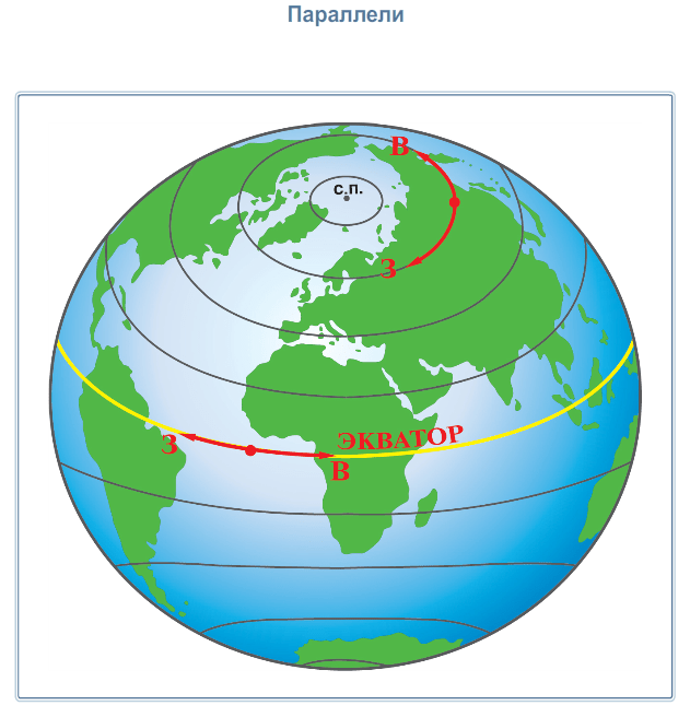
If you look at the globe, you can see many thin lines on it. Some run from top to bottom from the North Pole to the South Pole and are called meridians. On the globe and maps they indicate the direction of north and south. Other lines perpendicular to the meridians seem to encircle globe. These are parallels. On maps and the globe they are used to determine the direction to the west and east. The parallels are not equal in length. The longest parallel is the equator, the shortest are located near the poles.

1-2. Meridians and parallels are conventional lines on the globe and map. 3. Degree network. 4. Determination of the directions “north - south” along the meridian. 5. Determination of the directions “west - east” along the parallel.

Both parallels and meridians are conventional lines. They are needed in order to determine the location of geographic objects by geographic coordinates.
Questions and tasks
- What is a globe?
- How is it different from a map? Find in the text of the paragraph the answer to the question: what is the main advantage of a globe compared to a geographic map?
- What is the purpose of indicating scale on a globe and map?
- Why are parallels and meridians needed?
- Explain the geographical meaning of the word "orientate".
- Have you ever wondered what geographical object is located in another hemisphere in a place diametrically opposite to where your city is located? Find it on the globe and describe it according to the plan:
- what he is;
- what is it called;
- where it is located: in what climatic and time zones it is located, what geographical objects are nearby.
- Find the intersection of the equator and the prime meridian.
- Select from the list characteristic features parallels:
- have the shape of a circle;
- carried from pole to pole;
- they determine the direction “west - east”;
- all the same length.
Knowing that our planet has a shape very close to that of a sphere, and observing while traveling in various places visible rotation of the Sun and stars, ancient scientists established certain conventional lines for orientation on the earth's surface.
Let's go on a mental journey across the surface of the Earth. The position above the horizon of the imaginary axis of the world around which the daily rotation occurs firmament, will change all the time for us. In accordance with this, the pattern of movement of the starry sky will change. Traveling north, we will see that the stars in the southern part of the sky rise to a lower altitude every night. And the stars in the northern part - at the lower culmination - have a greater height. If we move long enough we'll get to North Pole. Here, not a single star rises or falls at all. It will seem to us that the whole sky is slowly spinning parallel to the horizon
Ancient travelers did not know that the apparent movement of stars was a reflection of the rotation of the Earth. And they have not been to the Pole. But it was necessary to have a landmark on the earth's surface. And for this purpose they chose a north-south line easily determined by the stars. This line is called the meridian.
Meridians can be drawn through any points on the surface of the Earth. Many meridians form a system of imaginary lines connecting the North and South Poles of the Earth, which is convenient to use for determining location.
Let's take one of the meridians as the initial one. The position of any other meridian in this case will be known if the reference direction is indicated and the dihedral angle between the plane of the desired meridian and the plane of the prime meridian.
The position of the prime meridian has changed many times over the centuries. In 1493, immediately after Columbus's first voyage to the shores of the West Indies, Pope Alexander VI divided the true peace between Spain and Portugal. The border of the future possessions of the two greatest sea powers cut Atlantic Ocean from pole to pole. And when decades later it became clear that the contours of the lands of the New World and the distant borders of Asia, it turned out that the western, “Spanish” half of the globe included all of America, with the exception of its Brazilian protrusion, and the eastern, “Portuguese” half included, in addition to Brazil , entirely Africa and Asia.
This longitude reference line existed for about one hundred and fifty years. In 1634, under Cardinal Richelieu, a special commission of French scholars proposed to draw the prime meridian closer to Europe, but in such a way that the entire territory of Europe and Africa would be east of it. For this purpose, the prime meridian was drawn through the westernmost point of the Old World, the western tip of the westernmost archipelago Canary Islands- Ferro Island. In 1884, at an astronomical conference in Washington, the initial reference meridian for the globe was taken to be the one that passes through the axis of one of the telescopes at the Greenwich Observatory. The Greenwich meridian remains as the zero meridian to this day.
The angle formed by any meridian with the initial one is called longitude. Longitude, for example, of the Moscow meridian 37? east of Greenwich.
To distinguish points lying on the same meridian from each other, we had to enter a second geographic coordinate - latitude. Latitude is the angle that a plumb line drawn at a given location on the Earth’s surface makes with the plane of the equator.
The terms “longitude” and “latitude” came to us from ancient sailors who described the length and width Mediterranean Sea. The coordinate that corresponded to the measurements of the length of the Mediterranean Sea became longitude, and the one that corresponded to the width became modern latitude.
Finding latitude, like determining the direction of the meridian, is closely related to the movement of the stars. Already ancient astronomers proved that the height of the celestial pole above the horizon is equal to the latitude of the place.
Let's assume that the Earth has the shape of a regular ball, and dissect it along one of the meridians, as shown in the figure. Let the person depicted in the picture as a light figure stand at the North Pole. For him, the direction is upward, i.e. the direction of the plumb line coincides with the axis of the world. The celestial pole is directly above his head. The height of the celestial pole here is 90?.
Since the apparent rotation of stars around the axis of the world is a reflection of the real rotation of the Earth, then at any point on the Earth, as we already know, the direction of the axis of the world remains parallel to the direction of the axis of rotation of the Earth. The direction of the plumb line changes when moving from point to point.
Let's take another person for example. The direction of the world axis remained the same as the first one. And the direction of the plumb line has changed. Therefore, the height of the celestial pole above the horizon here is not 90?, but much less.
From simple geometric considerations it is clear that the height of the celestial pole above the horizon is indeed equal to the latitude.
The line connecting points with the same latitudes is called a parallel.
Meridians and parallels form the so-called system of geographical coordinates. Each point on the earth's surface has a well-defined longitude and latitude. And vice versa, if the route and longitude are known, then you can build one parallel and one meridian, at the intersection of which you will get one single point.
In what form are the meridians and parallels drawn on the globe?
1. Lines of meridians and parallels on various maps. On a world map made by aligning the stripes of the globe along the equator, the meridians are straight lines of equal size. Parallels drawn perpendicular to them are also straight lines. Their length from the equator to the poles does not shorten, as on the globe, but remains the same. (What does this say?)
The equator and middle meridian of each hemisphere are shown as straight lines on the hemisphere map. Other meridians and parallels - curved lines different lengths. From the middle meridian to the edges, the length of the meridians increases. (What does this say?)
On the map of Kazakhstan, parallels are depicted as circular arcs. Meridians are represented by straight lines approaching the top of the map.
The map frame indicates longitude and latitude. On a map of the hemispheres, longitude is shown at the points where the meridians intersect the equator.
Meridians and parallels on the globe and maps are drawn through the same number of degrees (determine how many degrees they are shown on the globe, the map of the hemispheres and the map of Kazakhstan). Therefore, grids formed from changes in the lines of meridians and parallels are called degree grids.
2. Using meridian lines and parallels, it is very easy to determine geographic coordinates on a map. To do this, you first need to find out between which parallels of latitude and meridians of longitude the desired point is located. For example, the point is between 40° and 45° northern latitude, 70° and 75° east longitude (Fig. 32). To more accurately determine latitude on map, using a ruler, measure the distance (AB) between two parallels, as well as the distance between the lower parallel and the point N (AN). A segment on the map AB equal to 5°.
Rice. 32. Determination of the coordinate point.

To the distance AN in degrees we add 40°. If instead AN we would measure the VN and subtract this distance in degrees from 45°, we would still get the same result.
Longitude on the map is determined using the same method. Measure segments CD and CH with a ruler.

To the resulting value in degrees we add 70° and get the longitude of point H. In the same way as when determining the line of latitude, instead of a segment CH you can measure a segment DN. Then subtract the resulting value from 75°.

Rice. 33. Parts of degree grids on various maps.
1. Based on Figure 33, determine which maps each degree grid belongs to?
2. Find a point on the map of the hemispheres that is indicated by only one of the coordinates.
3. Using the map of Kazakhstan, determine approximately the geographic coordinates of your area.
The globe and geographical maps are “entangled” in a kind of grid consisting of intersecting lines. These lines did not appear on maps immediately, since in ancient times maps resembled simple plans.
The globe and its section planes
The Earth is a ball slightly flattened at the poles. The ball can be cut by planes along different directions. It can be cut, firstly, in the same way as an orange is divided into slices, and, secondly, in the same way as an orange is cut across the slices with a knife. With any method of dissecting a ball with planes, circles are obtained, the boundaries of which are circles. The diameter of the circles is greatest if the section planes pass through the center of the ball. The diameters of such circles are equal to the diameter of the ball.
Let's turn to and mentally dissect the globe with planes perpendicular to the Earth's axis of rotation. Circles parallel to each other appear on the surface of the globe. These circles are called parallels (from the Greek word parallclos - walking next to each other). The longest and main parallel is the equator, its length is 40,076 kilometers.
The equator is located at equal distance from the poles of the planet and divides the Earth into North and Southern Hemisphere. The length of other parallels decreases towards the south and north from the equator. All points lying on the same parallel are equally distant from the equator. The parallel lines show the west-east direction.
If you cut the globe with planes that pass through the axis of rotation of the Earth, then meridians will appear on the surface of the globe - semicircles connecting the Northern and South poles Earth. They are perpendicular to the parallels and show the north-south direction. The word “meridian” itself means “midday” (from Latin words meridianus), since the direction of all meridians coincides with the direction of the shadow from objects at noon.
All meridians have the same length - 20,005 kilometers. By agreement between the countries, the main, prime meridian is considered to be the meridian passing through the Greenwich Observatory in the suburbs of London. Therefore, this meridian is also called Greenwich. Greenwich meridian and its continuation on the opposite side
The globe divides the Earth into the Western and Eastern Hemispheres.

Parallels and meridians on maps
The parallels on the globe are circles, and the meridians are semicircles. But due to distortions when transferring the convex surface of the Earth onto a plane, the image of these lines looks different. Whatever the appearance of the parallels and meridians, on any map the directions to the east and west are determined only by the direction of the parallels, and to the north and south - only by the direction of the meridians. Thus, parallels and meridians allow one to orient themselves, that is, determine directions to the sides of the horizon.
You can draw as many lines of parallels and meridians on the globe and maps as you like. But only one meridian and one parallel pass through one point on the surface. The position of any point on a flat sheet can be characterized by two coordinate numbers that show the position of this point relative to the edges of the sheet.
On a spherical surface, the coordinates of points are determined with respect to the equator and the prime meridian. For this, a system of parallels and meridians is used.
Related articles
 The best amulets against the evil eye and damage Amulet against the evil eye with hands for children
 How to read the Psalter correctly
 Delicious dishes with sausages
 A glimpse of Bella. Romantic chronicle. A glimpse of genius. Messerer about Akhmadulina Boris Messerer glimpse of Bella romantic chronicle
 I dreamed that I was sailing on a boat on the river
 How to cook beef entrecote in a frying pan
 About the company Foreign language courses at Moscow State University
 Which city and why became the main one in Ancient Mesopotamia?
 Why Bukhsoft Online is better than a regular accounting program!
 Which year is a leap year and how to calculate it