
Establishment of a water protection zone. Water protection zone of the river and its legal regime
1. Water protection zones are territories that are adjacent to coastline seas, rivers, streams, canals, lakes, reservoirs and on which a special regime for carrying out economic and other activities is established in order to prevent pollution, clogging, siltation of these water bodies and depletion of their waters, as well as preserving the habitat of aquatic biological resources and other animal and flora.
2. Coastal protective strips are established within the boundaries of water protection zones, in the territories of which additional restrictions on economic and other activities are introduced.
3. Outside the territories of cities and other populated areas, the width of the water protection zone of rivers, streams, canals, lakes, reservoirs and the width of their coastal protective strip are established from the corresponding coastline, and the width of the water protection zone of the seas and the width of their coastal protective strip - from the line maximum tide. In the presence of centralized storm drainage systems and embankments, the boundaries of the coastal protective strips of these water bodies coincide with the parapets of the embankments; the width of the water protection zone in such territories is established from the embankment parapet.
4. The width of the water protection zone of rivers or streams is established from their source for rivers or streams with a length of:
1) up to ten kilometers - in the amount of fifty meters;
2) from ten to fifty kilometers - in the amount of one hundred meters;
3) from fifty kilometers or more - in the amount of two hundred meters.
5. For a river or stream less than ten kilometers long from source to mouth, the water protection zone coincides with the coastal protection strip. The radius of the water protection zone for the sources of a river or stream is set at fifty meters.
6. The width of the water protection zone of a lake or reservoir, with the exception of a lake located inside a swamp, or a lake or reservoir with a water area of less than 0.5 square kilometers, is set at fifty meters. The width of the water protection zone of a reservoir located on a watercourse is set equal to the width of the water protection zone of this watercourse.
7. The width of the water protection zone of Lake Baikal is established by Federal Law of May 1, 1999 N 94-FZ “On the protection of Lake Baikal”.
8. The width of the sea water protection zone is five hundred meters.
9. Water protection zones of main or inter-farm canals coincide in width with the allotment strips of such canals.
10. Water protection zones for rivers and their parts placed in closed collectors are not established.
11. The width of the coastal protective strip is established depending on the slope of the shore of the water body and is thirty meters for a reverse or zero slope, forty meters for a slope of up to three degrees and fifty meters for a slope of three degrees or more.
12. For flowing and drainage lakes and corresponding watercourses located within the boundaries of swamps, the width of the coastal protective strip is set at fifty meters.
13. The width of the coastal protective strip of lakes and reservoirs of particularly valuable fishery importance (spawning, feeding, wintering areas for fish and other aquatic biological resources), is set at two hundred meters regardless of the slope of the adjacent lands.
14. In the territories of populated areas, in the presence of centralized storm drainage systems and embankments, the boundaries of coastal protective strips coincide with the parapets of the embankments. The width of the water protection zone in such areas is established from the embankment parapet. In the absence of an embankment, the width of the water protection zone or coastal protective strip is measured from the coastline.
(as amended by Federal Laws dated July 14, 2008 N 118-FZ, dated December 7, 2011 N 417-FZ)
15. Within the boundaries of water protection zones it is prohibited:
1) use Wastewater for soil fertilization;
2) placement of cemeteries, cattle burial grounds, places of burial of production and consumption waste, chemical, explosive, toxic, poisonous and toxic substances, radioactive waste disposal sites;
(as amended by Federal Law dated July 11, 2011 N 190-FZ)
3) implementation of aviation measures to combat pests and plant diseases;
4) movement and parking Vehicle(except for special vehicles), with the exception of their movement on roads and parking on roads and in specially equipped places with hard surfaces.
16. Within the boundaries of water protection zones, design, construction, reconstruction, commissioning, operation of economic and other facilities are allowed, provided that such facilities are equipped with structures that ensure the protection of water bodies from pollution, clogging and depletion of water in accordance with water legislation and legislation in the field of protection environment.
(as amended by Federal Law No. 118-FZ of July 14, 2008)
17. Within the boundaries of coastal protective strips, along with the restrictions established by part 15 of this article, the following are prohibited:
1) plowing of land;
2) placement of dumps of eroded soils;
3) grazing of farm animals and organization for them summer camps, bath
18. The establishment on the ground of the boundaries of water protection zones and the boundaries of coastal protective strips of water bodies, including through special information signs, is carried out in the manner established by the Government Russian Federation.
(Part eighteen as amended by Federal Law No. 118-FZ of July 14, 2008)
More on the topic Article 65. Water protection zones and coastal protective strips:
- Article 8.42. Violation of the special regime for carrying out economic and other activities on the coastal protective strip of a water body, the water protection zone of a water body, or the regime for carrying out economic and other activities in the territory of the zone sanitary protection sources of drinking and domestic water supply
1. Water protection zones are territories that are adjacent to the coastline (borders of a water body) of seas, rivers, streams, canals, lakes, reservoirs and in which a special regime for economic and other activities is established in order to prevent pollution, clogging, siltation of these water bodies and depletion of their waters, as well as preserving the habitat of aquatic biological resources and other objects of flora and fauna.
(as amended by Federal Law dated July 13, 2015 N 244-FZ)
2. Coastal protective strips are established within the boundaries of water protection zones, in the territories of which additional restrictions economic and other activities.
3. Outside the territories of cities and other populated areas, the width of the water protection zone of rivers, streams, canals, lakes, reservoirs and the width of their coastal protective strip are established from the location of the corresponding coastline (border of the water body), and the width of the water protection zone of the seas and the width of their coastal protective strip stripes - from the line of maximum tide. In the presence of centralized storm drainage systems and embankments, the boundaries of the coastal protective strips of these water bodies coincide with the parapets of the embankments; the width of the water protection zone in such territories is established from the embankment parapet.
4. The width of the water protection zone of rivers or streams is established from their source for rivers or streams with a length of:
1) up to ten kilometers - in the amount of fifty meters;
2) from ten to fifty kilometers - in the amount of one hundred meters;
3) from fifty kilometers or more - in the amount of two hundred meters.
5. For a river or stream less than ten kilometers long from source to mouth, the water protection zone coincides with the coastal protective strip. The radius of the water protection zone for the sources of a river or stream is set at fifty meters.
6. The width of the water protection zone of a lake, reservoir, with the exception of a lake located inside a swamp, or a lake, reservoir with a water area of less than 0.5 square kilometers, is set at fifty meters. The width of the water protection zone of a reservoir located on a watercourse is set equal to the width of the water protection zone of this watercourse.
(as amended by Federal Law No. 118-FZ of July 14, 2008)
7. The boundaries of the water protection zone of Lake Baikal are established in accordance with the Federal Law of May 1, 1999 N 94-FZ “On the Protection of Lake Baikal”.
(Part 7 as amended by Federal Law dated June 28, 2014 N 181-FZ)
8. The width of the sea water protection zone is five hundred meters.
9. Water protection zones of main or inter-farm canals coincide in width with the allotment strips of such canals.
10. Water protection zones for rivers and their parts placed in closed collectors are not established.
11. The width of the coastal protective strip is set depending on the slope of the shore of the water body and is thirty meters for a reverse or zero slope, forty meters for a slope of up to three degrees and fifty meters for a slope of three degrees or more.
12. For flowing and drainage lakes and corresponding watercourses located within the boundaries of swamps, the width of the coastal protective strip is set at fifty meters.
13. The width of the coastal protective strip of a river, lake, or reservoir that is of particularly valuable fishery importance (spawning, feeding, wintering areas for fish and other aquatic biological resources) is set at two hundred meters, regardless of the slope of the adjacent lands.
14. In the territories of populated areas, in the presence of centralized storm drainage systems and embankments, the boundaries of coastal protective strips coincide with the parapets of the embankments. The width of the water protection zone in such areas is established from the embankment parapet. In the absence of an embankment, the width of the water protection zone or coastal protective strip is measured from the location of the coastline (the boundary of the water body).
(as amended by Federal Laws dated July 14, 2008 N 118-FZ, dated December 7, 2011 N 417-FZ, dated July 13, 2015 N 244-FZ)
15. Within the boundaries of water protection zones it is prohibited:
1) use of wastewater to regulate soil fertility;
(as amended by Federal Law dated October 21, 2013 N 282-FZ)
2) placement of cemeteries, cattle burial grounds, production and consumption waste disposal sites, chemical, explosive, toxic, poisonous and poisonous substances, radioactive waste disposal sites;
(as amended by Federal Laws dated July 11, 2011 N 190-FZ, dated December 29, 2014 N 458-FZ)
3) implementation of aviation measures to combat pests;
(as amended by Federal Law dated October 21, 2013 N 282-FZ)
4) movement and parking of vehicles (except for special vehicles), with the exception of their movement on roads and parking on roads and in specially equipped places with hard surfaces;
5) placement of gas stations, warehouses fuels and lubricants(except for cases where gas stations, warehouses of fuels and lubricants are located in the territories of ports, shipbuilding and ship repair organizations, infrastructure of inland waterways, subject to compliance with the requirements of legislation in the field of environmental protection and this Code), service stations used for technical inspection and repair of vehicles, vehicle washing;
(Clause 5 introduced by Federal Law dated October 21, 2013 N 282-FZ)
6) placement of specialized storage facilities for pesticides and agrochemicals, use of pesticides and agrochemicals;
(Clause 6 introduced by Federal Law dated October 21, 2013 N 282-FZ)
7) discharge of wastewater, including drainage water;
(Clause 7 introduced by Federal Law dated October 21, 2013 N 282-FZ)
8) exploration and production of common mineral resources (except for cases where exploration and production of common mineral resources is carried out by subsoil users engaged in exploration and production of other types of mineral resources, within the boundaries of mining allotments allocated to them in accordance with the legislation of the Russian Federation on subsoil resources and (or ) geological allotments based on the approved technical project in accordance with Article 19.1 of the Law of the Russian Federation of February 21, 1992 N 2395-1 “On Subsoil”).
(Clause 8 introduced by Federal Law dated October 21, 2013 N 282-FZ)
16. Within the boundaries of water protection zones, design, construction, reconstruction, commissioning, operation of economic and other facilities are allowed, provided that such facilities are equipped with structures that ensure the protection of water bodies from pollution, clogging, siltation and water depletion in accordance with water legislation and legislation in field of environmental protection. The choice of the type of structure that ensures the protection of a water body from pollution, clogging, siltation and water depletion is carried out taking into account the need to comply with the standards for permissible discharges of pollutants, other substances and microorganisms established in accordance with environmental legislation. For the purposes of this article, structures that ensure the protection of water bodies from pollution, clogging, siltation and water depletion are understood as:
1) centralized drainage (sewage) systems, centralized storm drainage systems;
2) structures and systems for the removal (discharge) of wastewater into centralized drainage systems (including rain, melt, infiltration, irrigation and drainage water), if they are designed to receive such water;
[Water Code RF] [Chapter 6] [Article 65]
1. Water protection zones are territories that are adjacent to the coastline of seas, rivers, streams, canals, lakes, reservoirs and on which a special regime for economic and other activities is established in order to prevent pollution, clogging, siltation of these water bodies and depletion of their waters, as well as preserving the habitat of aquatic biological resources and other objects of flora and fauna.
2. Coastal protective strips are established within the boundaries of water protection zones, in the territories of which additional restrictions on economic and other activities are introduced.
3. Outside the territories of cities and other populated areas, the width of the water protection zone of rivers, streams, canals, lakes, reservoirs and the width of their coastal protective strip are established from the corresponding coastline, and the width of the water protection zone of the seas and the width of their coastal protective strip - from the line of maximum tide . In the presence of centralized storm drainage systems and embankments, the boundaries of the coastal protective strips of these water bodies coincide with the parapets of the embankments; the width of the water protection zone in such territories is established from the embankment parapet.
4. The width of the water protection zone of rivers or streams is established from their source for rivers or streams with a length of:
1) up to ten kilometers - in the amount of fifty meters;
2) from ten to fifty kilometers - in the amount of one hundred meters;
3) from fifty kilometers or more - in the amount of two hundred meters.
5. For a river or stream less than ten kilometers long from source to mouth, the water protection zone coincides with the coastal protective strip. The radius of the water protection zone for the sources of a river or stream is set at fifty meters.
6. The width of the water protection zone of a lake, reservoir, with the exception of a lake located inside a swamp, or a lake, reservoir with a water area of less than 0.5 square kilometers, is set at fifty meters. The width of the water protection zone of a reservoir located on a watercourse is set equal to the width of the water protection zone of this watercourse.
7. The boundaries of the water protection zone of Lake Baikal are established in accordance with Federal Law of May 1, 1999 N 94-FZ “On the protection of Lake Baikal”.
8. The width of the sea water protection zone is five hundred meters.
9. Water protection zones of main or inter-farm canals coincide in width with the allotment strips of such canals.
10. Water protection zones for rivers and their parts placed in closed collectors are not established.
11. The width of the coastal protective strip is set depending on the slope of the shore of the water body and is thirty meters for a reverse or zero slope, forty meters for a slope of up to three degrees and fifty meters for a slope of three degrees or more.
12. For flowing and drainage lakes and corresponding watercourses located within the boundaries of swamps, the width of the coastal protective strip is set at fifty meters.
13. The width of the coastal protective strip of a river, lake, or reservoir that is of particularly valuable fishery importance (spawning, feeding, wintering areas for fish and other aquatic biological resources) is set at two hundred meters, regardless of the slope of the adjacent lands.
14. In the territories of populated areas, in the presence of centralized storm drainage systems and embankments, the boundaries of coastal protective strips coincide with the parapets of the embankments. The width of the water protection zone in such areas is established from the embankment parapet. In the absence of an embankment, the width of the water protection zone or coastal protective strip is measured from the coastline.
15. Within the boundaries of water protection zones it is prohibited:
1) use of wastewater to regulate soil fertility;
2) placement of cemeteries, cattle burial grounds, burial sites for production and consumption waste, chemical, explosive, toxic, toxic and noxious substances, radioactive waste disposal sites;
3) implementation of aviation measures to combat pests;
4) movement and parking of vehicles (except for special vehicles), with the exception of their movement on roads and parking on roads and in specially equipped places with hard surfaces;
5) placement of gas stations, warehouses of fuel and lubricants (except for cases where gas stations, warehouses of fuel and lubricants are located in the territories of ports, shipbuilding and ship repair organizations, infrastructure of inland waterways, subject to compliance with the requirements of legislation in the field of environmental protection and of this Code), service stations used for technical inspection and repair of vehicles, washing vehicles;
6) placement of specialized storage facilities for pesticides and agrochemicals, use of pesticides and agrochemicals;
7) discharge of wastewater, including drainage water;
8) exploration and production of common mineral resources (except for cases where exploration and production of common mineral resources is carried out by subsoil users engaged in exploration and production of other types of mineral resources, within the boundaries of mining allotments allocated to them in accordance with the legislation of the Russian Federation on subsoil resources and (or ) geological allotments on the basis of an approved technical design in accordance with Article 19.1 of the Law of the Russian Federation of February 21, 1992 N 2395-1 “On Subsoil”).
16. Within the boundaries of water protection zones, design, construction, reconstruction, commissioning, operation of economic and other facilities are allowed, provided that such facilities are equipped with structures that ensure the protection of water bodies from pollution, clogging, siltation and water depletion in accordance with water legislation and legislation in field of environmental protection. The choice of the type of structure that ensures the protection of a water body from pollution, clogging, siltation and water depletion is carried out taking into account the need to comply with the standards for permissible discharges of pollutants, other substances and microorganisms established in accordance with environmental legislation. For the purposes of this article, structures that ensure the protection of water bodies from pollution, clogging, siltation and water depletion are understood as:
1) centralized drainage (sewage) systems, centralized storm drainage systems;
2) structures and systems for the removal (discharge) of wastewater into centralized drainage systems (including rain, melt, infiltration, irrigation and drainage water), if they are designed to receive such water;
3) local treatment facilities for wastewater treatment (including rain, melt, infiltration, irrigation and drainage water), ensuring their treatment based on standards established in accordance with the requirements of legislation in the field of environmental protection and this Code;
4) structures for collecting production and consumption waste, as well as structures and systems for disposal (discharge) of wastewater (including rain, melt, infiltration, irrigation and drainage water) into receivers made of waterproof materials.
16.1. In relation to the territories of gardening, gardening or dacha non-profit associations of citizens located within the boundaries of water protection zones and not equipped with wastewater treatment facilities, until they are equipped with such facilities and (or) connected to the systems specified in paragraph 1 of part 16 of this article, it is allowed the use of receivers made of waterproof materials that prevent the entry of pollutants, other substances and microorganisms into the environment.
17. Within the boundaries of coastal protective strips, along with the restrictions established by part 15 of this article, the following are prohibited:
1) plowing of land;
2) placement of dumps of eroded soils;
3) grazing farm animals and organizing summer camps and baths for them.
18. The establishment on the ground of the boundaries of water protection zones and the boundaries of coastal protective strips of water bodies, including through special information signs, is carried out in the manner established by the Government of the Russian Federation.
1 comment on the entry “Article 65 Water Code of the Russian Federation. Water protection zones and coastal protective strips”
Article 65. Water protection zones and coastal protective strips
Commentary on Article 65
1. general review articles. The article includes 18 parts establishing the features of such elements of the legal regime of water protection zones and protective coastal strips, as features of the regime carrier object, regime restrictions and the boundaries of their action in space.
Part 1 contains the definition and goals of establishing a special regime for carrying out activities within the boundaries of water protection zones.
Part 2 provides for a specific type of zoning of water protection zones (in the form of coastal protective strips), as well as the possibility of introducing additional restrictions within the boundaries of coastal protective strips.
Parts 3 - 10 establish requirements for the size of water protection zones and rules for determining their boundaries. At the same time, part 7 contains a reference norm to Federal law dated 01.05.1999 N 94-FZ “On the protection of Lake Baikal”.
———————————
NW RF. 1999, No. 18. Art. 2220.
Parts 11 - 14 establish requirements for the size of coastal protective strips and rules for determining their boundaries.
Part 15 contains a list of regime restrictions within the boundaries of water protection zones, and part 16 establishes permissible types of impact within their boundaries, as well as the conditions for the legality of such impact.
Part 17 contains a list of additional regime restrictions within the boundaries of coastal protective strips, the possibility of which is provided for in part 2 of the commented article.
In accordance with Part 18, the right to establish the procedure for establishing the boundaries of water protection zones and coastal protective strips on the ground is vested in the Government of the Russian Federation. Accordingly, the Government of the Russian Federation has the right to independently determine the entities obligated to establish such boundaries on the ground.
2. Goals, scope and addressees of regulations.
The purpose of the article is to ensure increased protection of water bodies from adverse impacts by introducing additional restrictions and prohibitions in areas adjacent to such objects.
The scope of the article is extremely wide, since it concerns all water bodies on the territory of the Russian Federation.
Therefore, the addressees of the article are an indefinitely wide range of persons who permanently or temporarily use territories adjacent to water bodies. The special addressee of the article is the Government of the Russian Federation, which, in turn, has the right to determine the circle of persons obliged to establish the boundaries of the zones provided for in the article on the ground. In accordance with paragraph 3 of the Rules for establishing the boundaries of water protection zones and the boundaries of coastal protective strips of water bodies, these include the authorities state power subjects of the Russian Federation, Federal agency water resources and its territorial bodies.
———————————
3. Basic concepts. They are terms whose meaning was disclosed above (“coastline”, “sea”, “river”, “canal”, “stream”, “lake”, “reservoir” - see commentary to Article 5; “water area” , " water body", "water depletion" - see commentary to Art. 1; “habitat of flora and fauna” - see commentary to Art. 3). Specific to the article under comment are such concepts as “water protection zone”, “coastal protective strip", "canal right-of-way", " locality”, “storm drainage”, “embankment”, “parapet”, “water body of particular valuable fishery importance”.
3.1. Water protection zone. The word zone (from the Greek swvn - belt) means a section, area, belt or strip that has a certain quality characteristic.
———————————
Great Soviet Encyclopedia (in 30 volumes) / Ch. ed. A.M. Prokhorov. M.: Soviet Encyclopedia, 1972. T. 9. P. 572.
Establishment various kinds zones in environmental legislation is one of the methods of territorial protection by allocating areas with special conditions of use (see, for example, Articles 48 and 49 of Federal Law N 166-FZ “On Fisheries and Conservation of Aquatic Biological Resources”). Zoning is used to establish different legal regimes for areas of space that, before the establishment of zones, had a homogeneous legal regime (for example, the allocation of functional zones within national parks). The essence of zoning for environmental purposes is, as a rule, the establishment within zones of activity restrictions that are more stringent than in adjacent areas of space (for example, sanitary protection zones, security zones of specially protected natural areas and so on.). Establishing zones means establishing a spatial and temporal framework for restrictions on economic or other activities.
———————————
See in more detail: Commentary on the Federal Law of December 20, 2004 N 166-FZ “On Fisheries and Conservation of Aquatic Biological Resources” / Ed. O.L. Dubovik. M., 2011.
Because the natural complexes are very different in the set of components (mountains, forests, tundra, etc.), then here we mean homogeneity according to a certain legal basis, and not homogeneity in general. — Approx. auto
Accordingly, various types of zones (as well as belts) established for environmental purposes are a special case of specially protected areas. Consequently, the necessary elements of the legal regime nature protection zones are regime restrictions (special protection regime), spatial and, if necessary, temporary boundaries of the restrictions.
———————————
For more information on specially protected areas: General Assembly UN. Sixty-second session. Item 79 (a) of the provisional agenda. World ocean and maritime law. Report Secretary General. Addition. A/62/66/Add.2 (Russian). pp. 41 - 42; Educational and practical commentary on the land legislation of the Russian Federation / Ed. O.L. Dubovik. M.: Eksmo, 2006. P. 481 - 482; Kalenchenko M.M. Legal regime territorial protection marine environment/ Ed. O.L. Dubovik. M.: Gorodets, 2009. pp. 57 - 65.
In accordance with Part 1 of the commented article, water protection zones are territories that are adjacent to the coastline of certain water bodies (seas, rivers, streams, canals, lakes, reservoirs) and in which a special regime for carrying out economic and other activities is established. A special regime of activity is established for the following purposes:
— prevention of pollution, clogging, siltation of these water bodies;
— preventing the depletion of their waters;
— preservation of the habitat of aquatic biological resources and other objects of flora and fauna.
Water protection zones are established only for water bodies directly provided for in the commented article, namely: seas, watercourses (rivers, streams, canals) and reservoirs (lakes, reservoirs, ponds). The commented article obviously does not apply to swamps and natural outcrops groundwater, glaciers and snowfields, as well as underground water bodies.
Regime restrictions in water protection zones are provided for in part 15 of the commented article and include prohibitions on:
1) use of wastewater for soil fertilization;
2) placement of cemeteries, cattle burial grounds, burial sites for production and consumption waste, chemical, explosive, toxic, toxic and noxious substances, radioactive waste disposal sites;
3) implementation of aviation measures to combat pests and plant diseases;
4) movement and parking of vehicles (except for special vehicles), with the exception of their movement on roads and parking on roads and in specially equipped places with hard surfaces.
Summary of determination rules
width of water protection zones
water body
Water protection
zone, m Border measured Coastal protective
band (m) at
outside
populated
points
in the populated
point zero
or
reverse
slope
=3
Sea
500 lines
the greatest
parapet tide
(in the presence of
stormwater
sewer),
and with his
absence -
from the coastal
lines
50
Lake 50 shore
lines
Reservoir
not on
watercourse 50
Reservoir
on the watercourse equals
width
water protection
watercourse zones
Lake,
reservoir,
having special
valuable fish
economic
value set to
compliance
with the legislator
stuff about
fisheries
200 regardless
slope
Channel equals width
right-of-way
30
40
50
Source
watercourse within radius
50 m not defined within 50 m radius
Watercourse
length, km<10 =50 береговой
parapet lines (with
availability
stormwater
sewer),
and with his
absence -
from the coastal
lines
30
40
50
River, stream 50 00 00
Watercourse in
borders
swamps
50
50
———————————
Water protection zones are not established for rivers (parts thereof) placed in closed collectors.
For any lakes, reservoirs, with the exception of reservoirs located on watercourses. For lakes and reservoirs with an area of less than 0.5 square meters. km water protection zone is obviously not established.
The width of the coastal protective strip is equal to the width of the water protection zone and is 50 m, regardless of the slope.
Let us note that the boundaries of water protection zones may coincide in space with specially protected areas provided for by land, water legislation, legislation on wildlife, aquatic biological resources and the preservation of their habitat.
For example, in accordance with the Rules for the Establishment of Fish Protection Zones, the boundaries of the latter coincide with the boundaries of the water protection zones themselves. However, in accordance with paragraph 14 of these Rules, rules are also defined for establishing the width of fish protection zones for ponds, flooded quarries that have a hydraulic connection with rivers, streams, lakes, reservoirs and seas (50 m). Rosrybolovstvo is authorized to establish fishery protection zones and mark them on the ground. The rules for marking on the ground are approved by the relevant order of the Federal Agency for Fisheries. Fishing protection zones, unlike water protection zones, are created not by default (by force of law), but on the basis of the publication of a corresponding act by an authorized body.
———————————
Decree of the Government of the Russian Federation of October 6, 2008 N 743 “On approval of the Rules for the establishment of fishery protection zones” // SZ RF. 2008. N 41. Art. 4682.
Order of the Federal Agency for Fisheries dated December 15, 2008 N 410 “On approval of the Procedure for establishing the boundaries of fishery protection zones on the ground” // BNA of the Russian Federation. 2009. N 5.
See, for example: Order of Rosrybolovstvo dated November 20, 2010 N 943 “On the establishment of fishery protection zones of the seas, the shores of which fully or partially belong to the Russian Federation, and water bodies of fishery importance in the Republic of Adygea, Amur and Arkhangelsk regions” (not published).
Due to the special significance of Lake Baikal as a World Heritage Site, its legal regime and status is regulated by the Federal Law of 01.05.1999 N 94-FZ “On the Protection of Lake Baikal” and the regulatory legal acts adopted in its implementation. Part 7 of the commented article refers to these regulations in terms of establishing the width of water protection zones for a given water body. According to Part 1 of Art. 2 of this Law, the Baikal natural territory includes Lake Baikal, its water protection zone adjacent to Lake Baikal, its drainage area within the territory of the Russian Federation, specially protected natural areas adjacent to Lake Baikal, as well as the territory adjacent to Lake Baikal up to 200 kilometers wide to the west and northwest of it. Nature management within the boundaries of the Baikal natural territory is carried out in accordance with zoning into a central ecological zone (the most stringent restrictions), a buffer ecological zone and an ecological zone of atmospheric influence.
———————————
NW RF. 1999. N 18. Art. 2220.
The central ecological zone includes Lake Baikal itself with its islands, its water protection zone, as well as specially protected natural areas adjacent to Lake Baikal. We were unable to find any special regulations regarding the width of the water protection zone, so they are determined according to the general rules of the article under comment, that is, 50 m. Moreover, the list of regime restrictions in the central ecological zone (including) of Lake Baikal was approved by the Decree of the Government of the Russian Federation dated 08/30/2001 N 643 “On approval of the list of activities prohibited in the central ecological zone of the Baikal natural territory” and is more stringent than provided for in the commented article. In addition, the effect in space of the restrictions provided for by the said Resolution is much wider than the effect in space of the restrictions provided for by the water protection regime of the zone.
———————————
NW RF. 2001. N 37. Art. 3687.
3.2. Coastal protective strip. Within the meaning of parts 1 and 2 of the commented article, the coastal protection zone is part of the water protection zone, within the boundaries of which additional restrictions have been introduced in comparison with the water protection zone.
Restrictions within the boundaries of the coastal protective strip are provided for in Part 17 of the commented article and include such prohibitions as the ban on:
- plowing of land;
— placement of dumps of eroded soils;
— grazing farm animals and organizing summer camps and baths for them.
In accordance with paragraph 8 of Art. 27 of the Land Code of the Russian Federation prohibits the privatization of land plots within the “limits of the coastal strip” established in accordance with the Water Code of the Russian Federation.
A summary of the rules for determining the width of coastal protective strips is presented in the table below.
3.3. Canal right of way. Today, there are building rules that establish the procedure for determining and the width of reclamation canals depending on many factors. In most cases, the actual width of the right-of-way of existing canals is established in accordance with the design documentation and varies greatly depending on the type of canal construction (cut, half-cut, embankment or half-embankment) and its capacity. For example, the norms for land allocation for reclamation canals SN 474-75 establish the procedure for determining the width for reclamation canals with a capacity of no more than 10 cubic meters. m/s.
———————————
See, for example: Land allocation standards for reclamation canals SN 474-75.
The following data can be used as rough guidelines for channels with a capacity of no more than 10 m 3/s.
Right-of-way width for reclamation canals
Reclamation channels,
passing through:
Width along the bottom, m Width of the right of way in
unlimited use, m
min max min max
notch
semi-notch
half-embankment
embankments 0.4
As follows from the table, the width of the water protection zone of such canals will be from 17 to 45 m. If the width of the water protection coastal strip is determined according to the rules of part 11 of the commented article, its width will be from 30 to 50 m. In such a situation, the water protection coastal strip may completely coincide with the water protection zone or exceed it in size.
The width of land allocation strips for canals with a water throughput capacity of more than 10 cubic meters. m/s, canals developed by explosive methods, as well as those passing in areas prone to landslides and mudflows, and in populated areas should be determined by projects approved in the prescribed manner.
3.4. Locality. This is a populated place (settlement), the primary unit of human settlement within one built-up plot of land (city, urban-type settlement, village, etc.). A mandatory feature of a settlement is its constant use as a habitat, year-round or seasonally.
———————————
Soviet encyclopedic dictionary. M.: Sov. Encyclopedia, 1984. P. 861.
3.5. Storm drainage. Sewage refers to the disposal of domestic, industrial and waste water. A complete list of terms and definitions related to sewerage is enshrined in GOST 25150-82, but the concept of “storm sewerage” itself is not disclosed in it. To understand the content of this concept, let us turn to the Territorial Construction Standards of the Moscow Region. Within the meaning of Section 4 of these Territorial Construction Standards, storm drainage can be understood as the removal of surface runoff of three types (rain, melt and watering), formed in built-up areas as a result of precipitation and the operation of road surfaces. Such a sewerage system should also provide for the possibility of receiving drainage water from associated drainages, heating networks, general underground utility collectors, as well as uncontaminated wastewater from industrial enterprises.
———————————
GOST 19185-73. Hydraulic engineering. Basic concepts. Terms and Definitions. M.: Standards Publishing House, 1974. P. 3.
GOST 25150-82. Sewerage. Terms and Definitions.
Territorial building codes. Rain drainage. Organization of collection, purification and discharge of surface runoff (TSN DK-2001 of the Moscow region (TSN 40-302-2001) (put into effect by order of the Ministry of Regional Construction dated July 30, 2001 N 120 “On the implementation of Territorial Building Codes of the Moscow Region (TSN DK 2001 MO) )").
3.6. Embankment. This is a fencing or protective structure along the coastline. From the point of view of hydraulic engineering, embankments are wave walls built to protect coastal ledges, including the roadbed of coastal railways and roads, from waves. Such walls are sometimes called retaining walls. Wave breakers may, if possible, be erected under the protection of the beach with a width sufficient to dampen the design waves, in combination with groins or breakwaters. When designing wave walls, the recommendations of current building codes and regulations for the design of retaining walls should be taken into account.
———————————
GOST 19185-73. Hydraulic engineering. Basic concepts. Terms and Definitions. M.: Standards Publishing House, 1974. P. 13.
SP 32-103-97. Design of marine coastal protection structures. M.: Transstroy, 1998.
Embankments, as bank protection, protective, regulatory and fencing structures, are designed taking into account the possibility of their use for national economic and social purposes (as berthing, transport and other engineering structures, for mass recreation of the population and sports and recreational events).
———————————
See: SNiP June 2, 01-86. Hydraulic structures. Basic principles of design. M.: State Construction Committee, 1987.
3.7. Parapet. The word “parapet” (French parapet, Italian parapetto) in Russian means a low solid wall running along the edge of a roof, terrace, balcony, along an embankment, bridge (as a barrier); on the crest of a dam, jetty, dam, in shipping locks. In construction, it can also denote a separate element of the specified structures. For the purposes of this article, a parapet should be understood as a fence running along the embankment.
———————————
Soviet encyclopedic dictionary. M.: Sov. Encyclopedia, 1984. P. 964.
See, for example: GOST 23342-91. Architectural and construction products made of natural stone. Technical conditions. M.: Standards Publishing House, 1992. 9 p.
3.8. The slope of the shore of a water body. The concept of “slope” is very widespread in technical, natural sciences, and regulations in the field of technical regulation. In geodesy they are used to describe the terrain. From the point of view of geodesy, slope (also inclination) is an indicator of the steepness of the slope, that is, “the ratio of the elevation of the terrain to the horizontal extent over which it is observed.” For example, a slope of 0.015 corresponds to a rise of 15 m per 1000 m of distance.
———————————
See, for example: VSN 163-83. Accounting for deformations of river channels and banks of reservoirs in the area of underwater crossings of main pipelines (oil and gas pipelines). http://www.complexdoc.ru/ntdtext/487968 ; VSN 3-80. Instructions for the design of marine berth structures.
Soviet encyclopedic dictionary. M.: Sov. Encyclopedia, 1984. P. 1372.
When designing infrastructure facilities, information about slope angles (longitudinal and transverse) at their intended location must be included in the design documentation (clause 34 of the Regulations on the composition of sections of design documentation and requirements for their content).
———————————
Decree of the Government of the Russian Federation “On the composition of sections of project documentation and requirements for their content” dated February 16, 2008 N 87 // SZ RF. 2008. N 8. Art. 744.
The slope angle is measured during topographic work, usually using the trigonometric (geodesic) leveling method. It should be assumed that for the purposes of this article, the angle of the transverse slope must be taken into account.
3.9. A water body of particular value for fisheries. The fishery fund of inland freshwater bodies of Russia includes 22.5 million hectares of lakes, 4.3 million hectares of reservoirs, 0.96 million hectares of complex agricultural reservoirs, 142.9 thousand hectares of ponds and 523 thousand km of rivers. In addition, the Russian Federation also has a long sea coastline (about 60 thousand km).
———————————
See: paragraph 2.1 of the Strategy for the Development of Aquaculture in the Russian Federation for the period until 2020 (approved by the Ministry of Agriculture of the Russian Federation on September 10, 2007).
For the purpose of reproduction, conservation and rational use of aquatic biological resources, objects of fishery importance in accordance with paragraph 2.1.2 of the Model Rules for the Protection of Surface Waters are divided into three categories: highest, first and second.
———————————
Model rules for the protection of surface waters (approved by the State Committee for Nature Protection on February 21, 1991).
The highest category includes locations of spawning grounds, mass feeding grounds and wintering pits of especially valuable and valuable species of fish and other commercial aquatic organisms, as well as protected zones of farms of any type that carry out artificial breeding and cultivation of fish, other aquatic animals and plants.
The first category includes water bodies used for the preservation and reproduction of valuable fish species that are highly sensitive to oxygen levels.
The second category includes water bodies used for other fishing purposes.
———————————
For more details see: Khalchansky S.A. Commentary on Article 51 // Commentary on the Water Code of the Russian Federation / Ed. O.L. Dubovik. M.: Eksmo, 2007. P. 282 - 283.
4. Development of legislation. The establishment of water protection zones (strips) for purposes similar to those provided for in Part 2 of the commented article was provided for in Article 91 of the Water Code of the RSFSR of 1972. The content of restrictions was not provided for by this Code, since the rights to determine the procedure for their establishment and use were delegated to the Council of Ministers of the RSFSR, unless otherwise was not provided for by the legislation of the USSR. In accordance with Article 99 of the said Code, in order to maintain a favorable water regime of rivers, lakes, reservoirs, groundwater and other water bodies, to prevent water erosion of soils, siltation of reservoirs, deterioration of living conditions for aquatic animals, to reduce fluctuations in flow, etc. The establishment of water protection zones for forests was also envisaged.
The Water Code of the Russian Federation of 1995 (Article 111) differentiated the concepts of water protection zones and coastal protective zones. The content of these concepts, within the meaning of the 1995 CC of the Russian Federation, corresponds to the modern understanding, taking into account the fact that the commented Code more clearly defines the features of their legal regime. This is especially true for regime restrictions, which in the current RF CC are enshrined in law, and not in by-laws of the Government of the Russian Federation.
Changes were made to the commented article once, but affected several parts at once. Thus, in accordance with paragraph 19 of Article 1 of the Federal Law of July 14, 2008 N 118-FZ “On Amendments to the Water Code of the Russian Federation and Certain Legislative Acts of the Russian Federation,” the following changes were made to Article 65: sentence 1 of part is set out in a new edition 3; Part 6 has been supplemented with a new proposal; in part 14 the word “settlements” is replaced by the words “settlements”; the word “accommodation” is excluded from part 16; Part 18 is presented in a new edition.
———————————
NW RF. 2008. N 29 (part 1). Art. 3418.
The essence of the changes made to Part 3 was the need to reflect the characteristics of the seas as specific water bodies. In the previous edition, the boundaries of protective zones and strips for all water bodies outside populated areas were determined along the coastline. In accordance with the current edition, the border of protective zones (strips) of the seas is measured from the line of maximum tide.
Before changes were made to Part 6, the width of the protection zones (strips) of reservoirs was fixed and amounted to 50 m. In accordance with the current edition, the width of such a zone (strip) of a reservoir must correspond to the width of similar zones for the watercourse on which the reservoir is organized. For example, if the Kuibyshev Reservoir (Volga River) before the changes had a water protection zone 50 m wide, now it should be 200 m due to part 4 of the commented article.
The change in part 14 (replacing the word “settlement” with the words “settlement”) is recognized to distinguish concepts such as “a place where people live” (settlement) from “one of the territorial units of local government” (settlement).
———————————
See: part 1 art. 2 of the Federal Law of October 6, 2003 N 131-FZ “On the General Principles of the Organization of Local Self-Government in the Russian Federation” // SZ RF. 2003. N 40. Art. 3822.
The exclusion of the word “location” from part 16 of the commented article is also connected, in our opinion, with the bringing of regulatory legal acts into compliance with the Town Planning Code of the Russian Federation dated December 29, 2004 N 190-FZ, which enshrines and systematizes the rules of territorial zoning.
———————————
NW RF. 2005. N 1 (part 1). Art. 16.
The original version of Part 18 of the commented article contained a reference to land legislation in terms of determining the procedure for fixing the boundaries of security zones (strips). In the current version, the powers to establish the procedure for fixing borders are delegated to the Government of the Russian Federation.
5. Connection with other articles. The provisions of the commented article are applied insofar as this does not contradict the rules for the protection from pollution of swamps (Article 57), glaciers and snowfields (Article 58), protection of underground water bodies (Article 59), protection of forests (Article 63), as well as the provisions of Article 49 of the commented Code regarding the protection of water bodies containing medicinal water resources, special zones (Article 34) and sanitary protection (Part 2 of Article 43) sources of drinking and household purposes (see commentary to them).
6. The procedure for establishing boundaries. In accordance with Part 18 of the commented article, the Government of the Russian Federation is vested with the authority to determine the procedure for establishing water protection zones and coastal protective strips in the area. In accordance with its powers, the Government of the Russian Federation adopted the relevant Rules.
———————————
Decree of the Government of the Russian Federation of January 10, 2009 N 17 “On approval of the Rules for establishing on the ground the boundaries of water protection zones and the boundaries of coastal protective strips of water bodies” // SZ RF. 2009. N 3. Art. 415.
According to the Rules, the establishment of boundaries is aimed at informing citizens and legal entities about the special regime for carrying out economic and other activities within the boundaries of water protection zones and about additional restrictions on economic and other activities within the boundaries of coastal protective strips (clause 2).
In accordance with paragraph 4 of these Rules, establishing the boundaries of the water protection zone and the width of the coastal protective strip for each water body on the ground includes:
a) determining the width of the water protection zone and the width of the coastal protective strip;
b) description of the boundaries of the zone (strip), their coordinates and reference points;
c) displaying boundaries on cartographic materials;
d) establishing boundaries on the ground, including through the placement of special information signs.
Information on the boundaries of water protection zones and the boundaries of coastal protective strips of water bodies, including cartographic materials, is submitted to the Federal Water Resources Agency within a month for inclusion in the state water register (see commentary to Article 31).
The powers to establish boundaries on the ground are vested in government bodies.
Firstly, the Federal Agency for Water Resources in relation to all objects, the corresponding powers in respect of which were not transferred to the state authorities of the constituent entities of the Russian Federation. In particular, these are seas and (or) their parts, reservoirs, which are entirely located on the territories of the relevant constituent entities of the Russian Federation and the use of water resources of which is carried out to ensure drinking and domestic water supply to 2 or more constituent entities of the Russian Federation according to the list.
———————————
Secondly, government bodies of the constituent entities of the Russian Federation to the extent of the powers granted to them.
The specified public authorities are obliged to ensure the placement of special information signs along the entire borders of water protection zones and coastal protective strips of water bodies at characteristic points of the relief, as well as at places where water bodies intersect with roads, in recreation areas and other places of mass presence of citizens and the maintenance of these signs in in good condition (clause 6 of the Rules). Samples of special signs are approved by Order of the Ministry of Natural Resources of the Russian Federation dated August 13, 2009 N 249 “On approval of samples of special information signs to mark the boundaries of water protection zones and the boundaries of coastal protective strips of water bodies.”
———————————
BNA RF. 2009. N 43.
Land owners, landowners and land users of land plots, the land plots of which are subject to the regime of water protection zones and coastal protective strips, are obliged to ensure unhindered access for representatives of authorized government bodies in order to place special information signs on the relevant land plots and maintain them in proper condition.
———————————
Highlighted by us. From the wording of paragraph 7 of these Rules (“land plots on the lands of which there are water protection zones and coastal protective strips of water bodies”) it is assumed that the indicated zones (strips) are located on the land plots. However, the indicated zones (strips) are not physically located on the sites. Land plots on which regime restrictions apply may be part of lands of various categories with their own legal regime. The restrictions provided for in the commented article are legally established rules operating within certain boundaries, regardless of the legal regime of lands and land plots. For more details see: Krassov O.I. Land law: Textbook. M.: Yurist, 2007. P. 120 - 122.
The list of reservoirs, boundaries of water protection zones and coastal protective strips are established by the Federal Agency for Water Resources and its territorial bodies.
———————————
Order of the Government of the Russian Federation dated December 31, 2008 N 2054-r “On approval of the List of reservoirs that are entirely located on the territories of the relevant constituent entities of the Russian Federation and the use of water resources of which is carried out to ensure drinking and domestic water supply to two or more constituent entities of the Russian Federation” // SZ RF. 2009. N 2. Art. 335.
N Name of reservoir Location
1. Belgorod reservoir, Belgorod region
2. Boguchanskoye Reservoir Krasnoyarsk Territory, Irkutsk Region
3. Borisoglebsk reservoir, Murmansk region
4. Bratsk Reservoir, Irkutsk Region
5. Bureya Reservoir Khabarovsk Territory, Amur Region
6. Vazuzskoe reservoir, Smolensk region, Tver region
7. Velevskoe reservoir, Novgorod region
8. Upper Volga Reservoir, Tver Region
9. Verkhne-Ruzskoe reservoir, Moscow region
10. Verkhne-Svirskoe water reservoir
sche (river part) Leningrad region
11. Vilyuiskoe reservoir Republic of Sakha (Yakutia), Irkutsk region
12. Volgograd reservoir Volgograd region, Saratov region
13. Volkhov reservoir Leningrad region, Novgorod region
14. Votkinsk reservoir, Udmurt Republic, Perm region
15. Vyshnevolotsk reservoir, Tver region
16. Gorky reservoir, Ivanovo region, Kostroma region,
Nizhny Novgorod region, Yaroslavl region
17. Egorlyk reservoir Stavropol Territory
18. Zeya Reservoir, Amur Region
19. Ivankovskoe reservoir Moscow region, Tver region
20. Ikshinskoye Reservoir, Moscow Region
21. Iovskoe reservoir Republic of Karelia, Murmansk region
22. Iremel reservoir Republic of Bashkortostan, Chelyabinsk
region
23. Iriklinskoe reservoir, Orenburg region
24. Irkutsk reservoir, Irkutsk region
25. Istra reservoir Moscow region
26. Kaitakoski reservoir Murmansk region
27. Kama Reservoir, Perm Territory
28. Klyazminskoye Reservoir, Moscow Region
29. Knyazhegubskoe reservoir Republic of Karelia, Murmansk region
30. Kolyma Reservoir, Magadan Region
31. Krasnodar reservoir Republic of Adygea, Krasnodar region
32. Krasnoyarsk reservoir Republic of Khakassia, Krasnoyarsk Territory
33. Kubanskoye (Bolshoye)
reservoir Karachay-Cherkess Republic
34. Kuibyshev reservoir Republic of Mari El, Republic of Tatarstan,
Chuvash Republic, Samara region,
Ulyanovsk region
35. Kursk Reservoir Stavropol Territory
36. Lesogorsk reservoir Leningrad region
37. Mainskoye Reservoir Republic of Khakassia, Krasnoyarsk Territory
38. Mikhailovskoye Reservoir Kursk region, Oryol region
39. Mozhaisk reservoir Moscow region
40. Narva Reservoir, Leningrad Region
41. Nizhnekamsk reservoir Republic of Bashkortostan, Republic
Tatarstan, Udmurt Republic
42. Novosibirsk reservoir Altai Territory, Novosibirsk region
43. Novo-Troitskoye Reservoir, Stavropol Territory
44. Nyazepetrovskoe reservoir, Chelyabinsk region
45. Ozerninskoye Reservoir Moscow Region
46. Pestovskoye Reservoir, Moscow Region
47. Pravdinskoye Reservoir
(GES-3) Kaliningrad region
48. Proletarskoye Reservoir Republic of Kalmykia, Stavropol Territory,
Rostov region
49. Pronsky reservoir Ryazan region, Tula region
50. Pyalovskoye Reservoir, Moscow Region
51. Rayakoski reservoir Murmansk region
52. Rublevskoye Reservoir Moscow Region
53. Ruza reservoir Moscow region
54. Rybinsk reservoir, Vologda region, Tver region,
Yaroslavl region
55. Saratov reservoir Samara region, Saratov region,
Ulyanovsk region
56. Sayano-Shushenskoye Reservoir
From time immemorial, people settled and founded cities and villages on the banks of waterways. Our contemporaries also strive to acquire land and build a country house near bodies of water in a picturesque area. Residential and commercial real estate objects grow like mushrooms in the coastal areas of large and small rivers, lakes, and reservoirs. However, developers do not always adhere to the current standards that regulate construction in the water protection zone.
The country's legislative bodies adopted a new version of the Water Code; it came into force at the beginning of 2007 and made adjustments, removing many prohibitive norms and softening previously existing requirements. It has now become possible to place garden, vegetable and summer cottage plots in water protection zones, and their privatization is permitted.
What does the legislator mean by the concept of a water protection zone?
A water protection zone is an area that is adjacent to the boundaries of any water body (coastline), where a special procedure for economic and other activities is prescribed, that is, there are restrictions on the use of this territory. The purpose of establishing such a regime is to prevent the negative consequences of pollution of rivers and lakes, which can lead to depletion of water resources and cause serious harm to local fauna and flora. Protective coastal strips are located within the boundaries of the protective zones.
To find out whether the site is included in the territory of the water protection zone, it is advisable for the developer to contact the cadastral registration service and make a written request to the federal water resources authority, where the water register is maintained at the state level. This will make it possible to accurately determine which part of the site is located in the zone related to special conditions for the use of the territory (in this case, a water protection zone) and its specific area. An official response from the water industry will be required when obtaining permits for construction and will become the basis of the developer’s legitimacy in the event of any disputes.
Water protection zone: how many meters

The articles of the Water Code indicate the maximum parameter for the width of the water protection zone for territories located outside the city limits and outside the boundaries of any populated areas. It depends on the water body and its characteristics. In order not to conflict with legislative norms, when planning construction, you should know how many meters the water protection zone from the river forms. This parameter is determined by the length of the water flow, which is calculated from the source:
- when the length of the river is up to 10 km, the width of the zone, measured from the water’s edge, is 50 m;
- at 10 - 50 km - 100 m;
- for rivers over 50 km long - 200 m.
In the case when the distance from the source to the mouth of the river is less than 10 km, then the water protection zone and the coastal protective strip coincide, and in the area of the source it covers an area equal to a radius of 50 m.
According to the law, the water protection zone of a lake or reservoir with a water area of less than 0.5 km² (in addition to lakes located inside a swamp) is 50 meters. For reservoirs where species of valuable fish are found - 200 m. On the sea coast, this parameter corresponds to 500 meters.
When a body of water is used to supply drinking water, sanitary protection zones are established around it by law. And if the land falls into this category, then any construction here is prohibited. Such information is entered into the cadastral passport and indicates existing restrictions on the use of the site.
Construction in the water protection zone of a river or lake
Construction on areas that are fully or partially included in the water protection zone is permitted only on the condition that the house will not pollute the reservoir and all sanitary standards will be met. In other words, a residential building must have at least a wastewater treatment system (filtration). To dot all the i's and get specific and comprehensive information on this issue, it is rational to contact the territorial department of Rospotrebnadzor.
There is also a mandatory environmental assessment of project documentation, which makes it possible to exclude any violations of environmental legislation.

Since surface water bodies and the corresponding coastal strip are state or municipal property, they must be publicly available for use by all citizens, therefore any construction at the water's edge and on a 20-meter strip is unacceptable. At the same time, including the construction of fences that prevent people from free access to the coastal area. According to current legislation, the privatization of land plots within the borders of the coastal strip is also prohibited.
At the same time as compliance with the requirements regarding the water protection zone and coastal protective strip when constructing a residential building near a reservoir, it is necessary:
- have ownership rights to the site or have a lease agreement with the right to build on it with a certain type of permitting use (for individual housing construction or private household plots;
- comply with construction and sanitary standards and regulations when constructing a structure.
In addition to building restrictions in areas classified as water protection, there are a number of other prohibitions. For example, on coastal protective strips it is prohibited:
- break ground;
- herd animals;
- place soil dumps.
Cautions
Statistics show that during inspections carried out by services that control environmental management, about 20% of developers commit violations when constructing real estate in water protection zones. Therefore, when planning construction on a site adjacent to a lake, reservoir or river, you should determine the water protection zone of the water body and clearly know what construction restrictions exist.
An informed developer will save himself from unnecessary problems, penalties and other more serious troubles. The amount of fines for individuals is small, but violations are fraught with the fact that they will be required to be eliminated in court, including the forced demolition of the facility.
Adoption Water Code In general, this is a positive step in legislative activity. The main task Water Code there was and is protection of water bodies from pollution, primarily created by industrial enterprises, economic activities of various organizations and individuals. It seems that everything is fine here and we should only be happy about it. But it turns out everything is so simple. Some articles of the law directly or indirectly affected recreational fishing. How? Let's try to figure this out.
Let's consider one of the articles of the Water Code, which caused numerous disputes, a lot of discussions and bewilderment, how much bewilderment there is, sometimes just indignation. This is chapter 6" Protection of water bodies", Article 65, part 15, paragraph 4. Here's what it says:
"Within the Borders water protection zones Driving and parking are prohibited Vehicle(except for special vehicles), with the exception of their movement on roads and parking on roads and in specially equipped places with hard surfaces."
There are fishermen who go fishing on foot. This point, of course, does not concern them, but, nevertheless, the vast majority of fishing lovers come to fishing on personal motor transport. And here a lot of questions arise.
Firstly, how to carry equipment over such a distance? coastline, because the width water protection zone generally, depending on the reservoir, from 50 to 200 meters. Modern fishing involves a fairly weighty set of gear and other means necessary For fishing. Not everyone is young, not everyone is an athlete. And then fishing you still have to drag the catch, and, as a rule, uphill. And you also need to grab the trash. Many complain that they cannot calmly to fish, if they don’t see theirs next to them car. There were cases when they removed the wheels and entered the interior. There are no guarded sites on reservoirs, far from civilization.
If you read Article 65 carefully Water Code, then you will understand that traffic on roads and parking on the roads in water protection zones are not prohibited. Then the question arises: what is a road from the point of view of the Law. Federal Law No. 196-FZ “On Road Safety”, adopted on November 15, 1995, as amended on December 28, 2013, Article 2 reads:
"Road- a strip of land or a surface of an artificial structure equipped or adapted and used for the movement of vehicles. The road includes one or more carriageways, as well as tram tracks, sidewalks, curbs and dividing strips, if any."
Of the things listed in the last sentence, we are only interested in the side of the road. In other words, if within water protection zone passes road, including dirt, then you can move along it and leave car on the side of the road. Specially equipped parking on the banks reservoirs in the vast majority of cases absent. Therefore, there is nowhere else for vehicles to park except on the side of the road. And if your automobile moves off the road and stops on the grass near the shore, then there is a clear violation of the Law.
Here's another article Water Code concerning recreational fishing. This is Article 6 “Public Water Bodies”, Part 8, which reads:
"Every citizen has the right to use (without the use of motor vehicles) coastal strip public water bodies for movement and stay near them, including for carrying out amateur and sports fisheries and mooring of floating craft."
It also mentions mechanical vehicles, i.e. once again it is said what to use automobile transport within coastal strip it is forbidden.
TERMS
 Now we need to define the terms: what is coastline, what's happened coastal strip what is and what is.
Coastline is the boundary of a water body. It is defined for:
1) seas- at a constant water level, and in the case of periodic changes in water level - along the line of maximum ebb;
2) rivers, stream, canal, lakes, a flooded quarry - according to the average long-term water level during the period when they are not covered with ice;
3) pond, reservoirs- according to the normal retaining water level;
4) swamps - along the border of peat deposits at zero depth.
Coastal strip is a strip of land along coastline water body of public use intended for public use. Width coastal strip public water bodies is 20 m, with the exception of coastal strip channels, as well as rivers and streams, the length of which from source to mouth is no more than ten kilometers. Width coastal strip channels, as well as rivers and streams, the length of which from source to mouth is no more than ten kilometers, is 5 m.
Water protection zone- this is the territory adjacent to coastline seas, rivers, streams, canals, lakes, reservoirs and in which a special regime for carrying out economic and other activities is established in order to prevent pollution, clogging, siltation of the specified water bodies and depletion of their waters, as well as preserving the habitat of aquatic biological resources and other objects of flora and fauna.
Coastal protective strip- territory within the borders water protection zone, at which additional restrictions on economic and other activities are introduced.
WIDTH
Width water protection zone rivers or streams are established depending on their length from source to mouth: - up to 10 km - 50 m; - from 10 to 50 km – 100 m; - from 50 km and more – 200 m.
Width water protection zone lakes, reservoirs, with the exception of lakes located inside a swamp, or lakes, reservoirs with a water area of less than 0.5 square meters. km, set to 50 m. Width water protection zone reservoir located on a watercourse is set equal to the width water protection zone this watercourse.
Width water protection zone Lake Baikal is established separately (Federal Law of May 1, 1999 No. 94-FZ “On the Protection of Lake Baikal”).
Width water protection zone sea is 500 m.
Width coastal protective strip set depending on the slope of the bank water body and is 30 m (from coastline) for a reverse or zero slope, 40 m for a slope of up to 3 degrees and 50 m for a slope of 3 degrees or more.
For flow and waste lakes located within the boundaries of swamps and corresponding watercourses width coastal protective strip is 50 m. Width of coastal protection strip rivers, lakes, reservoirs of particularly valuable fishery importance (places for spawning, feeding, wintering of fish and other aquatic biological resources) is 200 m, regardless of the slope of the adjacent lands. In the territories of populated areas in the presence of centralized storm drainage systems and border embankments coastal protective strips coincide with the parapets of the embankments. Width water protection zone in such areas it is installed from the embankment parapet. In the absence of an embankment, the width water protection zone, coastal protective strip measured from coastline.
LENGTH
If with the concepts " coastline" And " coastal strip"everything is clear - they, by definition, extend throughout the entire body of water, then the question arises: Water protection zone– where is she? Everywhere, throughout body of water, or not? IN water code indicated only width of the water protection zone And coastal protective strip, i.e. distance from shores. What is their length?
Length water protection zone, like coastline, equal to the length body of water. And the length coastal protective strip different for different reservoirs. How to find out borders of the coastal protective strip?
BORDERS
 Boundaries of water protection zones And borders of coastal protective strips water bodies are installed in accordance with the Decree of the Government of the Russian Federation dated January 10, 2009 No. 17 “On approval of the Rules for establishing on the ground boundaries of water protection zones and water bodies."
The Resolution states that the establishment of borders is carried out by state authorities of the constituent entities of the Russian Federation, which ensure the determination width of the water protection zone And width of coastal protective strip for each water body, description of boundaries water protection zones and borders coastal protective strips water body, their coordinates and reference points, display boundaries of water protection zones And borders of coastal protective strips water bodies on cartographic materials, establishing boundaries of water protection zones And borders of coastal protective strips water bodies directly on the ground, including through the placement of special information signs. Boundary Information water protection zones and borders coastal protective strips water bodies, including cartographic materials, are entered into the state water register.
They (state authorities of the constituent entities of the Russian Federation) ensure the placement of special information signs all along the borders water protection zones And coastal protective strips water bodies at characteristic points of the relief, as well as at intersections water bodies roads, in recreation areas and other places where citizens are crowded and maintaining these signs in proper condition.
As a simple person who does not have access to cartographic materials with a description of the borders water protection zones and borders coastal protective strips water body, their coordinates and reference points, can find out the boundaries water protection zone or coastal protective strip? Not otherwise than by availability.
Part 18 of Article 65 caused a lot of discussion Water Code, which deals with the establishment on the ground boundaries of water protection zones And borders of coastal protective strips water bodies, including through special information signs. The article states that, establishing special information signs carried out in the manner established by the Government of the Russian Federation. Those. here you need to know the Decree of the Government of the Russian Federation of January 10, 2009 No. 17 “On approval of the Rules for establishing on the ground boundaries of water protection zones And borders of coastal protective strips water bodies", which determines the Rules for establishing on the ground boundaries of water protection zones And borders of coastal protective strips water bodies. This resolution describes samples information signs.
 Concerning information signs about availability water protection zone and its width, a heated discussion broke out among the fishermen. Like, if there is no sign, then there is no prohibition. This is wrong. Unlike road signs, the presence of a sign on body of water possible, but not necessary. Absence information signs, unfortunately, does not exempt you from responsibility, just like ignorance of the laws. A citizen is obliged to independently comply with the requirements of environmental legislation.
Part 5 of Article 6 “Water bodies of public use” states that information about restrictions on water use in water bodies of public use is provided to citizens by local government bodies not only through special information signs, but also through the media. Other methods of providing such information may also be used.
PUNISHMENT FOR VIOLATION
 What punishment is provided by the Law for violation of clause 4, part 15 of Art. 65 Water Code?
For violation of clause 4, part 15, art. 65 Water Code(traffic and parking of vehicles within water protection zone And coastal protective strip) administrative punishment under Part 1 of Art. 8.42 of the Code of the Russian Federation on Administrative Offenses in the form of a fine - from 3000 to 4500 rubles for each offender.
OBSTACLE TO FREE ACCESS TO WATER BODY
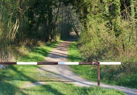 By the way, you can often see barriers established by certain persons without permission.
Here are excerpts from Article 6 “Public water bodies” Water Code.
Reservoirs that are in state or municipal ownership are water bodies of public use, that is, publicly accessible water bodies, unless otherwise provided by this Code.
Every citizen has the right to have access To water bodies public use and for free use them for personal and household needs, unless otherwise provided by this Code and other federal laws.
strip of land along coastline public water body ( coastal strip) is intended for general use.
For that violation, provided for in Article 8.12.1. Code of Administrative Offenses of the Russian Federation “Failure to comply with the conditions of provision free access citizens to a public water body and its coastal strip", superimposed fine for citizens in the amount of 3,000 to 5,000 rubles; for officials - from 40,000 to 50,000 rubles; for persons carrying out entrepreneurial activities without forming a legal entity - from 40,000 to 50,000 rubles. or administrative suspension of activities for up to 90 days; for legal entities - from 200,000 to 300,000 rubles. or administrative suspension of activities for up to 90 days.
IS IT POSSIBLE TO FISH IN THE COASTAL PROTECTIVE BAND?
 It’s not uncommon for fishermen to ask the following question: Is it prohibited? fishing V water protection zone or coastal protective strip?
No, not prohibited. To understand this, let’s return to Article 65 of Chapter 6 “Protection of Water Bodies” Water Code.
It states that in water protection zones a special regime for carrying out economic and other activities is established, and that within the boundaries coastal protective strips Additional restrictions on economic and other activities are introduced.
What economic activity is, I think, is clear, but what “other activity” is requires clarification. Recreational fishing does not fall under the concept of “other activities”. Other activity is, first of all, activity, i.e. This is an economic concept. A fishing- This is rest, not activity. In other words, fishing V coastal protective strips not prohibited. Only entry is limited to motor transport.
GRAZING AND WATERING ON THE SHORE OF FARM ANIMALS
 By the way, you can often find shore grazing and farm animal watering place.
Besides that animal grazing causes certain inconvenience to vacationers and, in particular, fishermen, this is also prohibited by the same article 65 Water Code, part 17 of which reads:
"Within the Borders coastal protective strips along with the restrictions established by part 15 of this article prohibited grazing farm animals and organizing summer camps and baths for them."
IS IT POSSIBLE TO WASH YOUR CAR ON THE SHORE?
 Wash cars Near bodies of water or in environmental protection zones forbidden throughout Russia, they only differ fines in the regions. Also, this action falls under the eighth chapter of the Code of Administrative Offenses: “Administrative offenses in the field of environmental protection and natural resource management.”
Similar articles
 Delicious dishes with sausages
 A glimpse of Bella. Romantic chronicle. A glimpse of genius. Messerer about Akhmadulina Boris Messerer glimpse of Bella romantic chronicle
 I dreamed that I was sailing on a boat on the river
 How to cook beef entrecote in a frying pan
 About the company Foreign language courses at Moscow State University
 Which city and why became the main one in Ancient Mesopotamia?
 Why Bukhsoft Online is better than a regular accounting program!
 Which year is a leap year and how to calculate it
 Prayer for lighting a lamp at home
 What was their strength and what was their weakness?