
How are the geographical coordinates of the location of the source written? Latitude and longitude - what is it in geography
Geographic longitude and latitude are used to precise definition the physical location of any object on the globe. The most in a simple way Finding geographic coordinates is using a geographic map. This method requires some theoretical knowledge to implement it. How to determine longitude and latitude is described in the article.
Geographic coordinates
Coordinates in geography are a system in which each point on the surface of our planet is assigned a set of numbers and symbols that allows the precise location of that point to be determined. Geographic coordinates are expressed in three numbers - latitude, longitude and altitude above sea level. The first two coordinates, that is, latitude and longitude, are most often used in various geographical problems. The origin of the report in the geographic coordinate system is at the center of the Earth. To represent latitude and longitude, spherical coordinates are used, which are expressed in degrees.
Before considering the question of how to determine longitude and latitude by geography, you should understand these concepts in more detail.
The concept of latitude

The latitude of a specific point on the Earth's surface is understood as the angle between the equatorial plane and the line connecting this point with the center of the Earth. Through all points of the same latitude, you can draw a plane that will be parallel to the plane of the equator.
The equatorial plane is the zero parallel, that is, its latitude is 0°, and it divides the entire globe into the southern and northern hemispheres. Accordingly, the north pole lies at the parallel of 90° north latitude, and the south pole lies at the parallel of 90° south latitude. The distance that corresponds to 1° when moving along a particular parallel depends on what kind of parallel it is. As latitude increases, moving north or south, this distance decreases. Therefore, is 0°. Knowing that the circumference of the Earth at the latitude of the equator has a length of 40075.017 km, we obtain the length of 1° along this parallel equal to 111.319 km.
Latitude shows how far north or south a given point on the Earth's surface lies from the equator.
The concept of longitude
The longitude of a specific point on the Earth's surface is understood as the angle between the plane passing through this point and the Earth's axis of rotation, and the plane of the prime meridian. According to the settlement agreement, the zero meridian is the one that passes through the Royal Observatory at Greenwich, located in the southeast of England. The Greenwich meridian divides the globe into eastern and
Thus, each line of longitude passes through the north and south poles. The lengths of all meridians are equal and amount to 40007.161 km. If we compare this figure with the length of the zero parallel, we can say that the geometric shape of planet Earth is a ball flattened at the poles.
Longitude shows how far west or east of the prime (Greenwich) meridian a specific point on Earth lies. If latitude has a maximum value of 90° (the latitude of the poles), then the maximum value of longitude is 180° west or east of the prime meridian. The 180° meridian is known as the International Date Line.
One might wonder interesting question, the longitude of which points cannot be determined. Based on the definition of a meridian, we find that all 360 meridians pass through two points on the surface of our planet; these points are the south and north poles.

Geographical degree
From the above figures it is clear that 1° on the Earth’s surface corresponds to a distance of more than 100 km, either along a parallel or along a meridian. For more accurate coordinates of an object, the degree is divided into tenths and hundredths, for example, they say 35.79 north latitude. This type of information is provided by satellite navigation systems such as GPS.
Ordinary geographic and topographic maps Fractions of a degree are expressed as minutes and seconds. Thus, each degree is divided into 60 minutes (indicated by 60"), and each minute is divided into 60 seconds (indicated by 60"). An analogy can be drawn here with the idea of measuring time.
Getting to know the geographic map

To understand how to determine geographic latitude and longitude on a map, you must first become familiar with it. In particular, you need to understand how longitude and latitude coordinates are represented on it. Firstly, upper part map shows Northern Hemisphere, lower part - southern. The numbers on the left and right sides of the map indicate latitude, and the numbers on the top and bottom of the map indicate longitude coordinates.
Before determining the latitude and longitude coordinates, you need to remember that they are presented on the map in degrees, minutes and seconds. This system of units should not be confused with decimal degrees. For example, 15" = 0.25°, 30" = 0.5°, 45"" = 0.75".
Using a geographic map to determine longitude and latitude
We will explain in detail how to determine longitude and latitude by geography using a map. To do this, you first need to purchase a standard geographical map. This map can be a map of a small area, a region, a country, a continent, or the entire world. To understand which card you are dealing with, you should read its name. At the bottom, under the name, the limits of latitude and longitude that are presented on the map can be given.
After this, you need to select a certain point on the map, some object that needs to be marked in some way, for example, with a pencil. How to determine the longitude of an object located at a selected point, and how to determine its latitude? The first step is to find the vertical and horizontal lines that lie closest to the selected point. These lines are latitude and longitude, the numerical values of which can be seen at the edges of the map. Let's assume that the selected point lies between 10° and 11° north latitude and 67° and 68° west longitude.
Thus, we know how to determine the geographic latitude and longitude of the object selected on the map with the accuracy that the map provides. In this case, the accuracy is 0.5°, both in latitude and longitude.
Determining the exact value of geographic coordinates
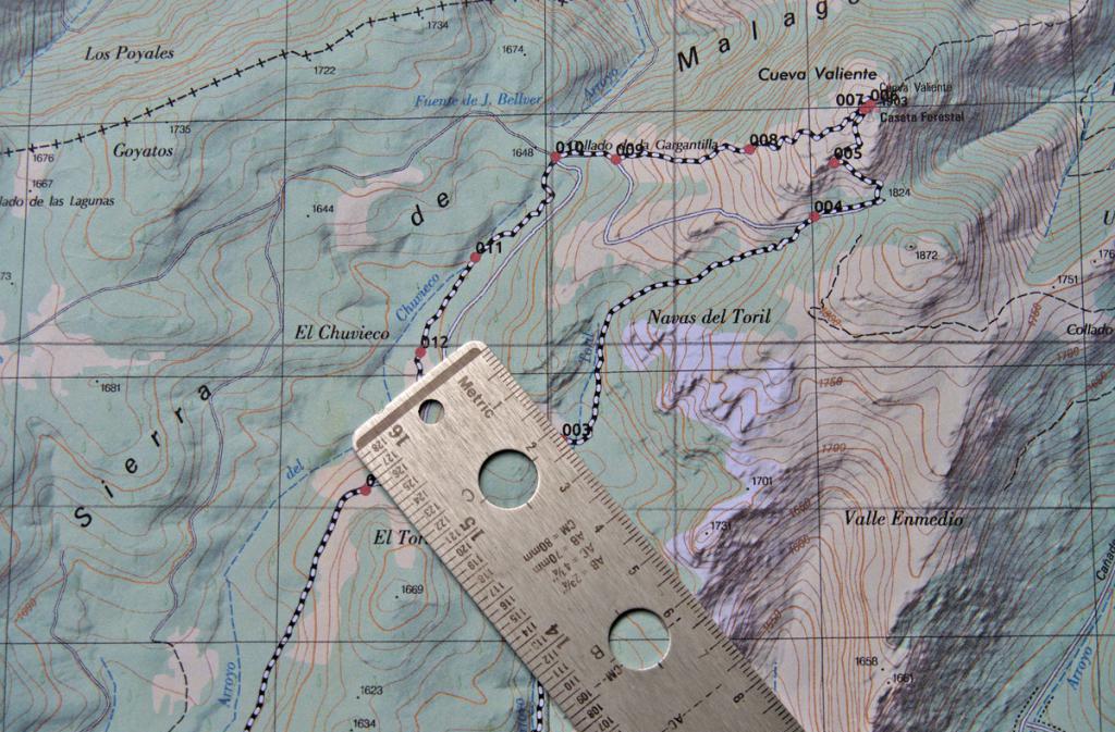
How to determine the longitude and latitude of a point more accurately than 0.5°? First you need to find out what scale the map you are working with is on. Typically, a scale bar is indicated in one of the corners of the map, showing the correspondence of distances on the map to distances in geographic coordinates and in kilometers on the ground.
After you have found a scale ruler, you need to take a simple ruler with millimeter divisions and measure the distance on the scale ruler. Let, in the example under consideration, 50 mm correspond to 1° latitude and 40 mm correspond to 1° longitude.
Now we position the ruler so that it is parallel to the lines longitude drawn on the map and measure the distance from the point in question to one of the nearest parallels, for example, the distance to parallel 11° is 35 mm. Compiling simple proportion and we find that this distance corresponds to 0.3° from the parallel of 10°. Thus, the latitude of the point in question is +10.3° (the plus sign means northern latitude).
Similar steps should be done for longitude. To do this, place the ruler parallel to the lines of latitude and measure the distance to the nearest meridian from the selected point on the map, let’s say this distance is 10 mm to the meridian 67° west longitude. According to the rules of proportion, we find that the longitude of the object in question is -67.25° (the minus sign means western longitude).
Converting the received degrees into minutes and seconds

As stated above, 1° = 60" = 3600". Using this information and the rule of proportion, we find that 10.3° corresponds to 10°18"0". For the longitude value we get: 67.25° = 67°15 "0"". In this case, the proportion was used for conversion once for longitude and latitude. However, in the general case, when after using the proportion once, fractional values of minutes are obtained, you should use the proportion a second time to obtain the value of incremental seconds. Note that the accuracy of determining coordinates up to 1" corresponds to the accuracy on the surface. globe, equal to 30 meters.
Recording received coordinates
After the question of how to determine the longitude of an object and its latitude has been answered, and the coordinates of the selected point have been determined, they should be written down correctly. The standard form of notation is to indicate longitude after latitude. Both values must be specified as closely as possible a large number decimal places, since the accuracy of the object’s location depends on this.
Defined coordinates can be represented in two different formats:
- Using only the degree icon, for example +10.3°, -67.25°.
- Using minutes and seconds, for example 10°18"0""N, 67°15"0""W.

It should be noted that in the case of representing geographic coordinates using degrees only, the words “north (south) latitude” and “east (west) longitude” are replaced by the corresponding plus or minus sign.
Modern technologies greatly facilitate our lives, making it easier, simpler and more convenient. Among the variety of such innovations, an important place is occupied by tools that allow you to easily navigate the terrain, build a convenient route to a particular geographic point, and find toponyms and other topographical objects on the map. One of the options for finding the desired object on the map is to search for it using geographic coordinates. And in this material I will tell you how to search by coordinates on Yandex Map, and what are the features of this search.
As you know, in the modern digital market for mapping services there are several competing companies that offer the user the ability to search for a point by coordinates. The list of such services includes the popular “Google Maps”, “Yandex.Maps”, “2GIS” (specializing in detailing cities), “Bing Maps”, “HERE WeGo”, “OpenStreetMap” and the previously existing “Yahoo! Maps" (now closed).
The main competitors in the Russian market are “ Google.Maps" And " Yandex.Maps" If the use of maps from Google is preferable on a global scale, then in the vastness of Russia we would recommend using the Yandex company’s service. The latter provides better coverage of Russia, has high level details, boasts a special tool for editing maps by users called “People's Map”, displays existing traffic jams in domestic cities, works well with “Geocoder”, and has other useful features.
 To determine your location in the Russian Federation, it is better to use Yandex.Maps
 At the same time, you can use the Yandex.Maps functionality either using a regular desktop browser on a PC or by installing the Yandex.Maps mobile application to your phone (for example, from the Play Market).
Search by latitude and longitude
If you are faced with the question of finding any geographical location on the map, or there is a need to point to some place on the map to another person, then you should use the method of determining the location geographical feature by its coordinates, including latitude or longitude.
Let me remind the reader that latitude coordinates show the location of the desired object in relation to the North and South Pole (i.e. it is a point between north and south), and longitude coordinates determine the location of the object between east and west.
The usual zero latitude is the equator, therefore the south pole is at 90 degrees south latitude, and the north pole is at 90 degrees north latitude.

In this case, northern latitude is designated by the letter “N” (Nord), South – by the letter “S” (South), western longitude by the letter “W” (West), and eastern longitude by the letter “E” (East). ).
Find a place by coordinates on the Yandex Map
To determine the latitude and longitude coordinates of an object, just open “Yandex.Maps”, find the object we need on the map, and click on it with the cursor. A small window will immediately open next to the cursor, informing about the selected object and indicating its latitude and longitude coordinates.

Now to find this object on the map it will be enough to write down the data numeric values, and then simply enter them separated by commas in the “Yandex.Maps” search bar and press enter. The map will immediately move to the given location and point you to the object specified by the entered coordinates.

It is most convenient to share such coordinates while somewhere in nature; the other party will easily find your location simply by entering your coordinates into the Yandex.Maps search bar.
In addition to finding the desired point by latitude and longitude, the Yandex.Maps functionality makes it possible to build a pedestrian, car, or bus route to it. To do this, just enter the numbers of latitude and longitude of the object you need into the search bar, click on enter, and after it is displayed on the screen, click on the button on the left “Build a route”.
 Click on “Build route” to build various options route to the desired geographical point
 You will need to enter the coordinates of the starting point of your journey (or type its address), and the service will automatically plot the most optimal route to it, and also indicate the approximate travel time and mileage.
Conclusion
If you need to search by your coordinates on Yandex Map, then it will be enough to enter the coordinates of the desired object by latitude and longitude in the search bar, and then press enter. If you just need to get the coordinates of the object you need, it will be enough to find it on Yandex.Map, click on it, and the necessary latitude and longitude coordinates will immediately be displayed in the sign that appears on the left.
To determine latitude It is necessary, using a triangle, to lower the perpendicular from point A to the degree frame onto the line of latitude and read the corresponding degrees, minutes, seconds on the right or left along the latitude scale. φА= φ0+ Δφ
φА=54 0 36 / 00 // +0 0 01 / 40 //= 54 0 37 / 40 //
To determine longitude It is necessary, using a triangle, to lower a perpendicular from point A to the degree frame of the line of longitude and read the corresponding degrees, minutes, seconds from above or below.
Determining the rectangular coordinates of a point on the map
The rectangular coordinates of the point (X, Y) on the map are determined in the square of the kilometer grid as follows: 
1. Using a triangle, perpendiculars are lowered from point A to the kilometer grid line X and Y and the values are taken XA=X0+Δ X; UA=U0+Δ U
For example, the coordinates of point A are: XA = 6065 km + 0.55 km = 6065.55 km;
UA = 4311 km + 0.535 km = 4311.535 km. (the coordinate is reduced);
Point A is located in the 4th zone, as indicated by the first digit of the coordinate at given.
9. Measuring the lengths of lines, directional angles and azimuths on the map, determining the angle of inclination of the line specified on the map.
Measuring lengths
To determine on a map the distance between terrain points (objects, objects), using a numerical scale, you need to measure on the map the distance between these points in centimeters and multiply the resulting number by the scale value. 
A small distance is easier to determine using a linear scale. To do this, a measuring compass is sufficient, the solution of which equal to the distance between given points on the map, apply it to a linear scale and take a reading in meters or kilometers. 
To measure curves, the “step” of the measuring compass is set so that it corresponds to an integer number of kilometers, and an integer number of “steps” is plotted on the segment measured on the map. The distance that does not fit into the whole number of “steps” of the measuring compass is determined using a linear scale and added to the resulting number of kilometers.
Measuring directional angles and azimuths on a map
.

We connect points 1 and 2. We measure the angle. The measurement is carried out using a protractor, it is located parallel to the median, then the angle of inclination is reported clockwise.
Determining the angle of inclination of a line specified on the map.
The determination follows exactly the same principle as finding the directional angle.
10. Direct and inverse geodetic problem on a plane. When computationally processing measurements taken on the ground, as well as when designing engineering structures and making calculations to transfer projects into reality, the need arises to solve direct and inverse geodetic problems. Direct geodetic problem . By known coordinates X 1 and at 1 point 1, directional angle 1-2 and distance d 1-2 to point 2 you need to calculate its coordinates X 2 ,at 2 .
|
|
Rice. 3.5. To the solution of direct and inverse geodetic problems |

The coordinates of point 2 are calculated using the formulas (Fig. 3.5): (3.4) where X,atcoordinate increments equal to
![]() (3.5)
(3.5)
Inverse geodetic problem .
By known coordinates X 1 ,at 1 points 1 and X 2 ,at 2 points 2 need to calculate the distance between them d 1-2 and directional angle 1-2. From formulas (3.5) and Fig. 3.5 it is clear that. (3.6) To determine the directional angle 1-2, we use the arctangent function. At the same time, we take into account that computer programs and microcalculators give the main value of the arctangent=  , lying in the range90+90, while the desired directional anglecan have any value in the range 0360.
The formula for transition from kdepends on the coordinate quarter in which the given direction is located or, in other words, on the signs of the differences y=y 2 y 1 and x=X 2 X 1 (see table 3.1 and figure 3.6). Table 3.1

Rice. 3.6. Directional angles and main arctangent values in the I, II, III and IV quarters
The distance between points is calculated using the formula
(3.6) or in another way - according to the formulas ![]() (3.7)
(3.7)
In particular, electronic tacheometers are equipped with programs for solving direct and inverse geodetic problems, which makes it possible to directly determine the coordinates of observed points during field measurements and calculate angles and distances for alignment work.
Each point on the planet's surface has a specific position, which corresponds to its own latitude and longitude coordinates. It is located at the intersection of the spherical arcs of the meridian, which corresponds to longitude, with the parallel, which corresponds to latitude. It is denoted by a pair of angular quantities expressed in degrees, minutes, seconds, which has the definition of a coordinate system.
Latitude and longitude are the geographic aspect of a plane or sphere translated into topographic images. For more exact location of any point, its altitude above sea level is also taken into account, which makes it possible to find it in three-dimensional space.
The need to find a point using latitude and longitude coordinates arises due to the duty and occupation of rescuers, geologists, military personnel, sailors, archaeologists, pilots and drivers, but it may also be necessary for tourists, travelers, seekers, and researchers.
What is latitude and how to find it
Latitude is the distance from an object to the equator line. Measured in angular units (such as degrees, degrees, minutes, seconds, etc.). Latitude on a map or globe is indicated by horizontal parallels - lines that describe a circle parallel to the equator and converge in the form of a series of tapering rings towards the poles.

Therefore, they distinguish the northern latitude - this is the entire part earth's surface north of the equator, as well as south - this is the entire part of the planet’s surface south of the equator. The equator is the zero, longest parallel. 
- Parallels from the equator line to the north pole are considered to be a positive value from 0° to 90°, where 0° is the equator itself, and 90° is the top north pole. They are counted as northern latitude (N).
- Parallels extending from the equator towards the south pole are indicated by a negative value from 0° to -90°, where -90° is the location of the south pole. They are counted as southern latitude (S).
- On the globe, parallels are depicted as circles encircling the ball, which become smaller as they approach the poles.
- All points on the same parallel will be designated by the same latitude, but different longitudes.
On maps, based on their scale, parallels have the form of horizontal, curved stripes - the smaller the scale, the straighter the parallel strip is depicted, and the larger it is, the more curved it is.
Remember! The closer to the equator a given area is located, the smaller its latitude will be.
What is longitude and how to find it
Longitude is the amount by which the position of a given area is removed relative to Greenwich, that is, the prime meridian.

Longitude is similarly characterized by measurement in angular units, only from 0° to 180° and with a prefix - eastern or western. 
- The Greenwich Prime Meridian vertically encircles the globe of the Earth, passing through both poles, dividing it into the western and eastern hemispheres.
- Each of the parts located west of Greenwich (in the Western Hemisphere) will be designated west longitude (w.l.).
- Each part distant from Greenwich to the east and located in the eastern hemisphere will be designated east longitude (E.L.).
- Finding each point along the same meridian has the same longitude, but different latitude.
- Meridians are drawn on maps in the form of vertical stripes curved in the shape of an arc. The smaller the map scale, the straighter the meridian strip will be.
How to find the coordinates of a given point on the map
Often you have to find out the coordinates of a point that is located on the map in a square between the two nearest parallels and meridians. Approximate data can be obtained by eye by sequentially estimating the step in degrees between the mapped lines in the area of interest, and then comparing the distance from them to the desired area. For accurate calculations You will need a pencil with a ruler, or a compass. 
- For the initial data we take the designations of the parallels closest to our point with the meridian.
- Next, we look at the step between their stripes in degrees.
- Then we look at the size of their step on the map in cm.
- Using a ruler, measure the distance from given point to the nearest parallel, as well as the distance between this line and the neighboring one, we convert it into degrees and take into account the difference - subtracting from the larger one, or adding to the smaller one.
- This gives us the latitude.
Example! The distance between the parallels 40° and 50°, among which our area is located, is 2 cm or 20 mm, and the step between them is 10°. Accordingly, 1° is equal to 2 mm. Our point is 0.5 cm or 5 mm away from the fortieth parallel. We find the degrees to our area 5/2 = 2.5°, which must be added to the value of the nearest parallel: 40° + 2.5° = 42.5° - this is our northern latitude of the given point. IN southern hemisphere the calculations are similar, but the result has a negative sign.
Similarly, we find longitude - if the nearest meridian is further from Greenwich, and the given point is closer, then we subtract the difference, if the meridian is closer to Greenwich, and the point is further, then we add it.
If you only have a compass at hand, then each of the segments is fixed with its tips, and the spread is transferred to the scale.
In a similar way, calculations of coordinates on the surface of the globe are carried out.
Latitude is the angle φ between the local zenith direction and the equatorial plane, measured from 0° to 90° on both sides of the equator. GEOGRAPHICAL COORDINATES - latitude and longitude, determine the position of a point on the earth's surface. On the maps search engines By default, coordinates are shown in degrees s decimal with "-" signs for negative longitude.
Eastern longitudes are considered to be positive, western longitudes are considered negative. To completely determine the position of a point in three-dimensional space, a third coordinate is needed - height. The main disadvantage in practical application G.S.K. in navigation is the large angular velocity of this system at high latitudes, increasing to infinity at the pole.
These coordinates are visible, for example, when plotting routes from arbitrary points. Other formats are also recognized when searching. The most common way to find a point on the surface of the Earth (globe) is well known - using geographic coordinates called latitude and longitude. Parallels and meridians form a grid system of coordinates on the surface of the Earth, with the help of which any place on Earth can be accurately determined.

We can imagine the Earth as a sphere rotating on its own axis. The ends of the axis are the North and South pole. The equator is a line of latitude with a value of 0°. This means that the Equator is the starting point for measuring other lines of latitude.

All lines of latitude are parallel to the equator and are sometimes also called parallels. The equator divides the Earth into the northern and southern hemispheres. Northern latitudes have positive values, and southern latitudes have negative values. Ultimately, it was decided that the line of zero longitude passes through the Greenwich Laboratory, located in England on the eastern outskirts of London. This line is also called the prime or Greenwich meridian.

What is longitude?
Each line of a circle can be divided into degrees with minutes and seconds. A degree of geographic longitude is 1/360 of the equator. The interval between the 39th and 40th parallels is 1° of latitude. The interval between the 175th and 176th meridians is 1° of longitude. Thus, the complete record of the geographical coordinates of the Ngauruhoe volcano is: 39° 07′ S, 175° 37′ E. 39 degrees, seven minutes south latitude.

What is latitude?
A second of latitude is approximately 0.03 kilometer, or approximately 30 meters. At the equator it is approximately 111 kilometers, the same distance as a degree of latitude. The size of longitude gradually decreases and tends to zero as the meridians converge at the Earth's poles. So, at a latitude of 45°, a degree of longitude is approximately 79 kilometers. As degrees of longitude vary in size, minutes and seconds of longitude also change, decreasing in size towards the poles.
Almost all globes have lines of parallels and meridians. Also, many globes have a so-called meridian arc, which not only serves to hold the sphere of the globe on a stand, but also helps determine geographic coordinates. There is a degree scale on the meridian arc (see photo). Latitude is determined using this scale. If there is no degree scale on the meridian arc, then there is such a scale on the prime meridian (Greenwich) and on the international date line (180° meridian). But longitude is determined by the equator.

If this point is above the equator, then it will be northern latitude, if below the equator, it will be southern latitude. Then determine the longitude. To do this, you need to look at the numerical value of the point of intersection of the equator and the meridian arc. This value must be viewed on the equator scale. It combines the beauty of levitation and modern technology.
An electromagnetic globe is a wonderful gift and souvenir for you and your friends. Geographic latitude points lying in the northern hemisphere (northern latitude) is usually considered positive, the latitude of points in the southern hemisphere is negative. It is customary to speak of latitudes close to the poles as high, and those close to the equator as low. The choice of the prime meridian is arbitrary and depends only on agreement.
Within geographic envelope‘height above sea level’ is usually used, measured from the level of the “smoothed” surface - the geoid. Such system of three coordinates turns out to be orthogonal, which simplifies a number of calculations. The orientation of the axes in the geographic coordinate system (GCS) is selected according to an algorithm. The orientation of the XYZ trihedron, due to the rotation of the earth and the movement of the vehicle, is constantly shifting with angular velocities.

There are no uniform rules for recording coordinates. All GPS navigators and major cartographic projects on the Internet operate in this coordinate system. The generally available accuracy when working with geographic coordinates is 5 - 10 meters on the ground. Coordinates are angular values and are expressed in degrees. Geographic coordinates will appear in the search bar of the map (as well as in the panel on the right).
A panel with the address and geographic coordinates will appear below the search bar. The current location is usually captured as a waypoint from which coordinates can later be read.
At the same time, the numerical values of the coordinates remain available (they can be seen in the search bar of the map that opens via the link). Please note that the point markers shown on the map are tied to roads, and their position corresponds only approximately to the entered coordinates. The recording forms can be simply converted into one another (1 degree = 60 minutes, 1 minute = 60 seconds).
On Google maps and Yandex maps, latitude first, then longitude (until October 2012, the reverse order was adopted on Yandex maps: first longitude, then latitude). Longitude - the angle λ between the plane of the meridian passing through this point, and the plane of the prime meridian, from which longitude is measured.
Related articles
 The best amulets against the evil eye and damage Amulet against the evil eye with hands for children
 How to read the Psalter correctly
 Delicious dishes with sausages
 A glimpse of Bella. Romantic chronicle. A glimpse of genius. Messerer about Akhmadulina Boris Messerer glimpse of Bella romantic chronicle
 I dreamed that I was sailing on a boat on the river
 How to cook beef entrecote in a frying pan
 About the company Foreign language courses at Moscow State University
 Which city and why became the main one in Ancient Mesopotamia?
 Why Bukhsoft Online is better than a regular accounting program!
 Which year is a leap year and how to calculate it