
What are parallels and meridians. &14
The points of intersection of the earth's axis with the surface of the globe are called poles (North and South). The Earth makes one revolution around this axis in 24 hours.
A circle is drawn at the same distance from the poles, which is called the equator.
Parallel - lines conditionally drawn along the surface of the Earth parallel to the equator. The parallels on the map and globe are directed to the west and east. They are not equal in length. The longest parallel is the equator. The equator is an imaginary line on earth's surface, obtained by mentally dissecting the ellipsoid into two equal parts (Northern and Southern Hemisphere). With such a dissection, all points of the equator turn out to be equidistant from the poles. The plane of the equator is perpendicular to the Earth's axis of rotation and passes through its center. There are 180 meridians on Earth, 90 of them north of the equator, 90 to the south.
The parallels of 23.5° north and south latitude are called tropical circles or simply the tropics. On each of them once a year noon sun happens at the zenith, i.e. sun rays fall vertically.
The parallels of 66.5° north and south latitude are called the polar circles.
Circles are drawn through the North and South poles, meridians are the shortest lines conventionally drawn on the surface of the Earth from one pole to another.
The prime or prime meridian is drawn at the Greenwich Observatory (London, UK). All meridians have the same length and semicircular shape. There are 360 meridians on Earth, 180 to the west of the zero, 180 to the east. The meridians on the map and globe are directed from north to south.
For precise definition the location of any object on the surface of the earth, the equator line alone is not enough. Therefore, the hemispheres are mentally separated by many more planes parallel to the equatorial plane - these are parallels. All of them, like the equatorial plane, are perpendicular to the axis of rotation of the planet. You can draw as many parallels as you like, but usually they are drawn with an interval of 10-20°. The parallels are always oriented from west to east. The circumference of the parallels decreases from the equator to the poles. At the equator it is greatest, and at the poles it is zero:
Length of parallel arcs
|
Parallels |
Length 1° in km |
When the globe is crossed by imaginary planes passing through the Earth’s axis perpendicular to the equatorial plane, great circles are formed - meridians. Translated into Russian, the word “meridian” means “noon line”. Indeed, their direction coincides with the direction of the shadow from objects at noon. If you keep walking in the direction of this shadow, you will definitely come to the North Pole. Meridians are the shortest line, conventionally drawn from one pole to another. All meridians are semicircles. They can be drawn through any points on the surface of the Earth. They all intersect at the pole points. The meridians are oriented from north to south. The average arc length of 1° meridian is calculated as follows:
40,008.5 km: 360° = 111 km
The length of all meridians is the same. The direction of the local meridian at any point can be determined at noon by the shadow of any object. In the Northern Hemisphere, the end of the shadow always points north, in the Southern Hemisphere it always points south.
The image of lines of meridians and parallels on the globe and geographical maps is called a degree grid.
Geographic latitude is the distance of any point on the earth's surface north or south of the equator, expressed in degrees. Latitude is northern (if the point is located north of the equator) and southern (if south of it).
Geographic longitude is the distance of any point on the earth's surface from the prime meridian, expressed in degrees. To the east of the prime meridian there will be eastern longitude (abbreviated: E.L.), to the west - western longitude (W.L.).
Geographic coordinates - geographic latitude and geographic longitude of a given object.
In the form of what lines are the meridians and parallels drawn on the globe?
1. Lines of meridians and parallels on various maps.
On a world map made by aligning the stripes of the globe along the equator, the meridians are straight lines of equal size. Parallels drawn perpendicular to them are also straight lines. Their length from the equator to the poles does not shorten, as on the globe, but remains the same. (What does this say?)
The equator and middle meridian of each hemisphere are shown as straight lines on the hemisphere map. Other meridians and parallels - curved lines different lengths. From the middle meridian to the edges, the length of the meridians increases. (What does this say?)
On the map of Kazakhstan, parallels are depicted as circular arcs. Meridians are represented by straight lines approaching the top of the map.
The map frame indicates longitude and latitude. On a map of the hemispheres, longitude is shown at the points where the meridians intersect the equator.
Meridians and parallels on the globe and maps are drawn through the same number of degrees (determine how many degrees they are shown on the globe, the map of the hemispheres and the map of Kazakhstan). Therefore, grids formed from changes in the lines of meridians and parallels are called degree grids.
2. Using meridian lines and parallels, it is very easy to determine geographic coordinates on a map. To do this, you first need to find out between which parallels of latitude and meridians of longitude the desired point is located. For example, the point is between 40° and 45° north latitude, 70° and 75° east longitude (Fig. 32). To more accurately determine latitude on map, using a ruler, measure the distance (AB) between two parallels, as well as the distance between the lower parallel and the point N (AN). A segment on the map AB equal to 5°.
Rice. 32. Determination of the coordinate point.

To the distance AN in degrees we add 40°. If instead AN we would measure the VN and subtract this distance in degrees from 45°, we would still get the same result.
Longitude on the map is determined using the same method. Measure segments CD and CH with a ruler.

To the resulting value in degrees we add 70° and get the longitude of point H. In the same way as when determining the line of latitude, instead of a segment CH you can measure a segment DN. Then subtract the resulting value from 75°.

Rice. 33. Parts of degree grids on various maps.
1. Based on Figure 33, determine which maps each degree grid belongs to?
2. Find a point on the map of the hemispheres that is indicated by only one of the coordinates.
3. Using the map of Kazakhstan, determine approximately the geographic coordinates of your area.
Almost all of you have paid attention to the “mysterious lines” on maps and globes representing latitude (parallels) and longitude (meridians). They form a grid coordinate system by which any place on Earth can be precisely located - and there is nothing mysterious or complicated about it. Parallels and meridians are imaginary lines on the surface of the Earth, and latitude and longitude are their coordinates that determine the position of points on the surface of the Earth. Any point on Earth is the intersection of a parallel and a meridian with latitude and longitude coordinates. This can be most clearly studied using a globe, where these lines are marked.
But first things first. Two places on Earth are determined by its rotation around its own axis - these are North and South Poles. On globes, the axis is the rod. The North Pole is located in the North Arctic Ocean which is covered sea ice, and explorers in the old days reached this pole on a sleigh with dogs (it is officially believed that the North Pole was discovered in 1909 by the American Robert Peri). However, since the ice moves slowly, the North Pole is not an actual, but rather a mathematical object. U South Pole, on the other side of the planet, there is a permanent physical location on the continent of Antarctica, which was also discovered by land explorers (the Norwegian expedition led by Roald Amundsen in 1911).
 Halfway between the poles on the “waist” of the Earth there is a large line of a circle, which on the globe is represented as a seam: the junction of the northern and southern hemispheres; this circle line is called - equator. The equator is a line of latitude with a value of zero (0°). Parallel to the equator, above and below it, there are other lines of the circle - these are other latitudes of the Earth. Each latitude has a numerical value, and the scale of these values is measured not in kilometers, but in degrees north and south from the equator to the poles. The poles have the following values: North +90°, and South -90°. Latitudes located above the equator are called northern latitudes
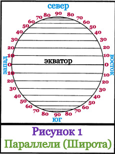
, and below the equator - southern latitudes. Lines with degrees of latitude are called parallels, since they run parallel to the Equator and are parallel to each other. If parallels are measured in kilometers, then the lengths of different parallels will be different - they increase as they approach the equator and decrease towards the poles. All points of the same parallel have the same latitude, but different longitude (longitude is described below). The distance between two parallels that differ by 1° is 111.11 km. On the globe, as well as on many maps, the distance (interval) from one latitude to another latitude is usually 15° (this is approximately 1,666 km). In Figure 1, the interval is 10° (this is approximately 1,111 km). The equator is the longest parallel, its length is 40,075.7 km.
Halfway between the poles on the “waist” of the Earth there is a large line of a circle, which on the globe is represented as a seam: the junction of the northern and southern hemispheres; this circle line is called - equator. The equator is a line of latitude with a value of zero (0°). Parallel to the equator, above and below it, there are other lines of the circle - these are other latitudes of the Earth. Each latitude has a numerical value, and the scale of these values is measured not in kilometers, but in degrees north and south from the equator to the poles. The poles have the following values: North +90°, and South -90°. Latitudes located above the equator are called northern latitudes
, and below the equator - southern latitudes. Lines with degrees of latitude are called parallels, since they run parallel to the Equator and are parallel to each other. If parallels are measured in kilometers, then the lengths of different parallels will be different - they increase as they approach the equator and decrease towards the poles. All points of the same parallel have the same latitude, but different longitude (longitude is described below). The distance between two parallels that differ by 1° is 111.11 km. On the globe, as well as on many maps, the distance (interval) from one latitude to another latitude is usually 15° (this is approximately 1,666 km). In Figure 1, the interval is 10° (this is approximately 1,111 km). The equator is the longest parallel, its length is 40,075.7 km.
Working with texts and working with atlas p.22.
Students are divided into groups and answer questions.
– What are meridians?
– What do they look like and why are they called that.
– Length of meridians.
– What are parallels?
– Why are they called that, what do they look like?
– length of parallels.
Teacher: What did you guys learn about the parallels?
Student response.
Parallels are lines that are conventionally drawn along the surface of the earth parallel to the equator. Let's remember what the equator is? Shown on the map and globe. At each point the parallel is directed east and west. Parallels are circles whose length decreases from the equator to the poles. Do you remember what a pole is? The longest parallel is the equator. Its length is 40,000 km. All parallels are circles whose length decreases from the equator to the poles. On a map of the hemispheres, parallels are curved lines (arcs), and the equator is a straight line.
Meridians. Translated into Russian, the word “Meridian” means “midday line”. Its direction coincides with the direction of the shadow from objects at noon. If you walk all the time in the direction of this shadow. Then you will definitely come to north pole, and in reverse side- to Yuzhny.
Meridians – shortest lines, conventionally carried out on the surface of the earth from one geographic pole to another. All meridians are semicircles, converge at the poles and have the same length. On physical map hemispheres, the median meridian is a straight line, and the rest are arcs.
Teacher: Parallels and meridians are drawn through a certain number of degrees.
Working with maps and atlases.
Teacher: Find the equator on a physical map and on a globe. On contour map mark the equator. He divides globe into two hemispheres (Northern and Southern). Parallels are counted from the equator. Parallels 10, 20, ... 80 degrees of the Northern or Southern Hemisphere.
Mark a 10 degree parallel Northern Hemisphere and 20 degrees southern hemisphere.
The parallels are marked in a circle on the map of the hemispheres and on the meridian (zero) on the globe.
Teacher: By agreement between the countries, the prime meridian is considered to be the meridian passing through the Greenwich Observatory in the suburbs of London. Therefore, this meridian is also called Greenwich. On the map it is shown as a thicker line than other meridians.
Mark the prime meridian on the map. It divides the globe into two hemispheres (Western and Eastern). Meridians are marked at the equator.
We complete task 43 page 36.
Teacher: Why are parallels and meridians needed?
Students: For orientation, determine and indicate the location of various geographical objects on the surface of the Earth.
Teacher: Right. The ancient Greek scientist Eratosthenes, who lived in 276 -194. BC e., for the first time proposed drawing conventional lines - parallels and meridians - on images of the earth's surface.
Determination of directions by meridians and parallels.
Teacher: What do we know? What directions do the conditional lines show?
Students: Parallels - west, east.
Meridians – north, south.
Teacher: At each point the parallel is perpendicular to the meridian. Therefore, if you stand on the ground facing north, in the direction of the meridian, spread your arms to the sides, they will indicate the direction of the parallels, i.e. west – east.
The main and intermediate sides of the horizon are determined by meridians and parallels.
- In which direction is Cairo from St. Petersburg?
- In what direction is Moscow from St. Petersburg?
- In what direction from Moscow is the Red Sea.
Using conditional lines, you can determine not only directions, but also indicate the position of parts of territories and objects. To determine, for example, the northern and southern parts of Australia, you need to place a pointer on the map along a parallel that runs approximately in the middle of the continent. To the north of the pointer there will be a northern part, and to the south there will be a southern part. How do you define the western and eastern parts of Australia.
Meridians and parallels
Meridians and parallels
Meridians and parallels
coordinate lines on a map or globe. Meridians are lines of constant longitude that pass through both poles of the planet and indicate the north-south direction, and parallels are lines of constant latitude that run parallel to the equator in the west-east direction. Intersecting, these lines form a grid of geographic coordinates on the map. Usually, integer meridians and parallels are drawn, but for accurate plotting and recording of coordinates, the grid can be condensed to minutes (and on large-scale maps - even to seconds). For this purpose, the cards have a minute frame where fractions of degrees are marked. Depending on the method of determination, astronomical, geodetic, geographical and geomagnetic meridians and parallels are distinguished, and celestial sphere, respectively, are the celestial meridians and parallels.
Geography. Modern illustrated encyclopedia. - M.: Rosman. Edited by prof. A. P. Gorkina. 2006 .
See what “meridians and parallels” are in other dictionaries:
Geographical encyclopedia
Small circles of a sphere, formed by its intersection with a plane parallel to some basic plane (horizon, equator, ecliptic); otherwise a circle, all points of which have the same latitude, declination or altitude. Daily P. stars small circles, ... ... Encyclopedic Dictionary F. Brockhaus and I.A. Efron
- (historical) The initial concept of K. can be found even among savages, especially those living along the shores and about you and having a more or less clear idea of the areas surrounding their territory. Travelers who questioned the Eskimos of North America and ... Encyclopedic Dictionary F.A. Brockhaus and I.A. Efron
Mappings of the entire surface of the Earth's ellipsoid (See Earth's ellipsoid) or any part of it onto a plane, obtained mainly for the purpose of constructing a map. Scale. Control stations are built on a certain scale. Reducing mentally... ... Great Soviet Encyclopedia
An example of a map projection is the Mercator projection. A map projection is a mathematically defined way of displaying the surface of an ellipsoid on a plane. The essence of projections is related to the fact that the figure of the Earth ... Wikipedia
An example of a map projection is the Mercator projection. A map projection is a mathematically defined way of displaying the surface of an ellipsoid on a plane. The essence of projections is due to the fact that the figure of the Earth is an ellipsoid, not unfoldable in ... ... Wikipedia
Mapping the entire surface of the earth's ellipsoid or any part of it onto a plane, obtained mainly for the purpose of constructing a map. Kp are drawn on a certain scale. By mentally reducing the earth's ellipsoid in Mraz, we obtain its geometric shape. model... ... Mathematical Encyclopedia
Meridian(s) Meridians and parallels are coordinate lines on a map or globe. Meridians are lines of constant longitude that pass through both poles of the planet and indicate the north-south direction, and parallels are lines of constant latitude that go... ... Geographical encyclopedia
Meridians and parallels are coordinate lines on a map or globe. Meridians are lines of constant longitude that pass through both poles of the planet and indicate the north-south direction, and parallels are lines of constant latitude that run parallel... ... Geographical encyclopedia
Books
- , Grebenshchikov Boris Borisovich. Few rock musicians have not only reached the very heights of fame, but also studied so thoroughly everything related to the work of his predecessors and colleagues. Since 2005, Boris Grebenshchikov has been leading...
Related articles
 The best amulets against the evil eye and damage Amulet against the evil eye with hands for children
 How to read the Psalter correctly
 Delicious dishes with sausages
 A glimpse of Bella. Romantic chronicle. A glimpse of genius. Messerer about Akhmadulina Boris Messerer glimpse of Bella romantic chronicle
 I dreamed that I was sailing on a boat on the river
 How to cook beef entrecote in a frying pan
 About the company Foreign language courses at Moscow State University
 Which city and why became the main one in Ancient Mesopotamia?
 Why Bukhsoft Online is better than a regular accounting program!
 Which year is a leap year and how to calculate it