
Mende cards. Which ancient maps are best used to find coins? Designation of the 1850 Vladimir Mende map
Buyan-field - Flat, elevated place, open on all sides
Vzlobok - A small steep hill.
Veres - Juniper.
Volok (Volok) - Forest or forest clearing
Vspolye - The edge of the field, pasture.
Vyselok (Vyselok) - A small village, predominantly owned, located near single-patrimonial villages.
Greatest - Greatest, highest, highest.
City (G.) - A fortified or walled village. Management status assigned to a volost, district or provincial in relation to other settlements.
Griva - An oblong hill covered with forest.
Village - A village without a church, whose inhabitants are mainly peasants from various departments and live without a landowner.
Right hand - Right hand.
Dresva - Coarse sand.
Zapan - Backwater or river bay.
Zaseka (Zas.) - Defensive structure. It was a combination of dead forest ambushes, an earthen rampart and a ditch with forts and separate fortresses. The fortifications served as defensive lines that protected against raids by the Golden Horde, who systematically plundered and destroyed Russian cities and villages and took the population into captivity, as well as to protect roads.
Zybun (Zyb.) - A quagmire, an impassable (disastrous) place.
Koshevnik - Wood timber floated down the river.
Cumulus sands (Cumulus) - Accumulations of loose sand around bushes and shrubs... Height 30-50 cm, less often up to 1-2 m. In places they consist of gravel. They usually form in areas with close groundwater - on salt marshes, the coasts of lakes, seas and rivers.
Lying meadow - Worthless, bad meadow.
Monastery, monastery (Mon.) - These consist of various types of monastic hostels, the latter of which sometimes coincide in their meaning with graveyards or estates of the spiritual department.
Grange (m. or Grange) - If it is owned, then most of it is near single-patrimonial villages, or it has the meaning of an estate at a plant and factory, if it belongs to persons of the tax-paying classes.
Myanda - Pine.
Novina - Cleared but not plowed land in the forest.
Dump (Opt.) - A mound of waste rock, slag, formed during the development of mineral resources.
Oselok - Oselok Vlad. wasteland, a place abandoned by its inhabitants; fallow, lie low. Oselok, Oblesye, Oselok or obselye, psk. hard newly populated place, settlement, new settlements, settlement.
Oselye - Oselye is akin to an outskirts, the land around the village.
Perekop - Ditch.
Tares - Weed
Pogost (Pog. or Pogost) - Has a church and a population consisting of clergy and clergy. The word graveyard comes from the word guest. The place where merchants traded was called a graveyard. With the adoption of Christianity, churches began to be built near graveyards. In the 15-16th centuries. churchyards begin to die off, hence the word graveyard has a second meaning - a lonely church.
Undercut (Under.) - A cleared place in the forest.
Disgrace - Review, watch.
Midnight - North.
Posad (P. or Pos.) - An order of huts or a row of houses. A settled settlement located outside a city or fortress.
Pochinok, village and farm (Poch.) - Same as settlement. Farmsteads, however, often have the significance of estates due to their agricultural nature. New settlements arising on the first raised site were called repairs. When the original courtyard was replaced by one or two others, it became a village.
Wasteland (Pust.) - A village turned into a wasteland if there were no residential courtyards left in it and the arable land was abandoned.
Selishche - A large village or settlement where there is more than one church.
Village (S.) - A village with a church, whose inhabitants are mainly peasants from different departments.
Seltso (Sel.) - A village of exclusively owner-occupied nature with a manor house and various owner-owned establishments, or a village in which a landowner with peasants or several landowners live. A village that was previously a village may also have the name.
Sloboda, Forshtat (Slob.) - A village with more than one church, a settlement outside a city or fortress.
Thorn - Prickly bush
Estate (Us.) - They are of two kinds. Estates of the spiritual department are similar in character to graveyards in terms of the nature of the population. Owner's estates differ either in their agricultural nature or as the location of landowners at a factory or plant
Shuitsa - Left hand.
Church land (CL) - A plot of land belonging to a church parish or monastery
Yaroslavl province was established under Paul the First in 1796 from the lands that were part of the governorship of the same name, established in turn during the administrative reform under Catherine the Second in 1777. Previously (since 1719) these territories were part of the Yaroslavl province, which was alternately as part of the St. Petersburg and Moscow provinces (until the abolition of the division of Russian provinces into provinces in 1775). During its existence throughout the subsequent pre-revolutionary period, the composition and boundaries of the districts of the Yaroslavl province changed several times. So, in 1796, during the reorganization of the governorship into a province, Petrovsky district was abolished, in 1822 the cities of Romanov and Borisoglebsk were merged, and Romanovsky district was renamed Romanov-Borisoglebsky, etc.
In Yaroslavl province in whole or in part
There are the following maps and sources:
(except for those indicated on the main page of the general
all-Russian atlases, where this province may also be)
|
Survey map of Yaroslavl province(1778-1797) Survey map - non-topographic, hand-drawn map of the late 18th century on a scale of 1 inch = 2 versts 1cm=840m or 1 inch = 1 verst 1 cm = 420 m. As a rule, the county was drawn on the parts that are shown on the assembly sheet. Some of the maps date back to the period of Catherine II 1775-96, Paul I, having come to power, changed the boundaries of counties within the provinces (which, in turn, Alexander I returned with some changes to its original place), while some of the maps of the General Land Survey fund have only survived for this period. The maps are color, detailed, and divided by county. The purpose of the map is to show the boundaries of land plots. More details |
|
|
|
|
|
|
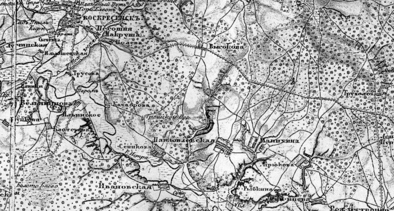
 Map of Mende Yaroslavl province(1850s)
  Modern borders of the Yaroslavl region differ from pre-revolutionary ones, which is very schematically shown in the figure with a fragment of the Yaroslavl region.
Attention to non-residential properties. It happens that when starting to work with maps, some seekers who have just joined our hobby focus exclusively on populated areas, losing sight of the most interesting objects for exploration, for example, bridges, crossings, etc.
But often in the immediate vicinity of the same crossing there was also housing, and not indicated anywhere. A gatehouse, a house (two, three), or simply a place once favored by people to rest on the road: a hollow, a mound, a clearing in the forest. There can be many options, so it doesn’t hurt to “turn on” your imagination.
Additional materials. Additional materials such as: economic notes for the map, well, let's say to PGM. Having acquired such extras. materials, you will have the opportunity to collect a lot of useful information about a specific settlement and will be able to more vividly and fully imagine the life, wealth, and occupations of those people who once inhabited the settlement you are researching. In fact, there are a lot of documents useful to a search engine, and in order to find some of them there is no need to even go to the archive. Sometimes it’s enough to rummage around on the Internet, at least this will help you decide on the direction of your search, that is, understand what exactly you need.
Now about what types of cards there are. Let me cite, as an example, several, although well-known for a long time, that nevertheless still arouse interest among search engines for ancient maps. To my considerable surprise, from communicating with guys I accidentally met on the field, who had recently become interested in instrument searching, it turned out that they had no idea about any maps at all, they had only heard about the gene. headquarters
General survey maps (GLM) - not yet topographical (without indicating latitude and longitude), maps of counties from the late 18th century, after the redistribution of borders in 1775-78. Under Paul 1, the boundaries of the provinces were changed, and Alexander 1, who reigned after him, returned the borders to their original place, but with some changes; unfortunately, some of the maps of the General Land Survey fund were preserved only for this period. The results of the survey were plans for the general survey of districts of 35 provinces of the Russian Empire. PGMs of counties, as a rule, consist of several parts and they were drawn by hand at one time. The maps contain many small details and objects. Sadly, some parts have reached us with significant losses, but, in any case, they are very interesting and it is precisely the PGM that leaves us the space to use our own imagination. Of course, they are in the public domain and not the originals, but the photos are sold. One-layout survey on a scale of 1 inch = 1 verst or 1 cm = 420 m; two-layout survey on a scale of 1 inch = 2 versts or 1 cm = 840 m.

Map of Mende A.I.
Maps of Mende are already topographical (indicating latitudes and longitudes); over 17 years, surveys covered an area of 345,000 square meters. versts The work was based on materials from the General Survey. This work was carried out using the method of semi-instrumental photography. The maps are made on a scale of 1 inch = 1 verst or 1 cm = 420 m; 1 inch = 2 versts or 1 cm. = 840 m.
In total, eight published provinces are known: Tver, Yaroslavl, Vladimir, Ryazan, Nizhny Novgorod, Penza, Simbirsk, Tambov.
The work was carried out by a corps of military topographers.
Map of European Russia I.A. Strelbitsky.
This map is one of the main works of the famous Russian topographer, General Staff Lieutenant General of the Infantry I.A. Strelbitsky.
A “Special Map of European Russia” was published by the military topographic department of the main headquarters, edited by Strelbitsky; The map is made on a scale of 10 versts per inch, consists of 178 sheets and includes not only the European possessions of Russia.
A map of European Russia, compiled on the basis of the provision on the liberation of peasants from serfdom, on February 19, 1861, and published with the special permission of the State Council for a visual explanation of the largest and smallest mental allotments in all areas of Russia.
Of course, it’s not such a detailed map, but sometimes it can be useful.

Composite map and sample map of Strelbitsky.
As mentioned above, here are the most famous and easily accessible maps of the Russian Empire. In reality, there are much more of them, not to mention maps of the USSR General Staff And maps of the Red Army. There are also quite interesting “Hans” maps from the Second World War.
One more thing, when comparing Soviet or modern maps with ancient ones, do not forget - a mile and a kilometer are not the same thing. And other length measures do not correspond to modern ones.
In general, the ability to read a topographic map will never be superfluous. This is really very convenient: you compare a map of the 18th century with a map of the 19th century, observe the changes, then make a comparison with maps of the USSR, and only then superimpose all this on a satellite image.
It will be especially useful to work with maps for those who are just starting their search activities. In any case, it will certainly reduce the number of idle trips.
, Russian Empire
Alexander Ivanovich Mende (Mendt, 1798 or 1800 - ) - Russian lieutenant general, cartographer. He served in the Caucasus, then in the cartographic department, and later managed a widow's house and the educational part of Moscow institutes. Under the supervision of Mende (based on the encyclopedia), topographical boundary atlases of the Tver, Ryazan and Tambov provinces were compiled.
He was educated at the St. Petersburg Gymnasium. In 1813 he was enlisted as a column leader in the Retinue of His Imperial Majesty. In 1813-1821 was engaged in topographic survey of the territory of Finland.
In 1824 he was sent to the headquarters of the 2nd Army. In 1825 he was promoted to staff captain.
Since 1845 - head of military survey of the Vitebsk province.
In 1847, he was appointed to assist the boundary department to supervise cartographic work during the delimitation of provinces.
In 1847-1866. headed large-scale topographic and cartographic work in the central provinces of Russia, organized by the Military Topographic Depot of the General Staff, the Land Survey Department and the Russian Geographical Society to correct land survey atlases. In 1856, for distinguished service, he was promoted to lieutenant general.
He was married to Elizaveta Antonovna Hoffman" (11/14/1818 - 05/18/1870). Their children: Nikolai (1844), Vladimir (1849), Natalya (1849), Lydia (1852).
The Mende couple are buried in Moscow at the German Cemetery.
Some evidence
Recognition of the merits of Mende A.I. is the anniversary medal “In memory of the fiftieth anniversary of the Corps of Military Topographers. 1872". This medal bears the names of 81 people who headed the Russian military topographic service until 1872 or who glorified it with their creative achievements. The sequence of surnames is not alphabetical, but by merit.
Correction of provincial atlases
Under his leadership, the “Topographic boundary atlas of the Tver province” (v. 1-12, 1853-57; scale 1:84,000), the “Topographic boundary atlas of the Ryazan province” (1860), as well as maps of the Ryazan and Tambov provinces (over 1 thousand sheets in total).
For his “zeal and labor” in compiling maps of the Tver province, M. was awarded the highest favor in 1850.
His name is associated with extensive work, called “Mende surveys,” organized by the Russian Geographical Society, the Military Topographic Depot of the General Staff and the Land Survey Department to correct land survey atlases.
A. I. Mende from 1847 to 1866 supervised topographical and cartographic work in the central provinces of Russia.
Until the stage of publication of the atlas of the Tver province in 1853, the head of the work was referred to as A. I. Mendt. A similar spelling is present in the materials of the “A. I. Mende Foundation” Russian State Archive of Ancient Acts (RGADA), as well as in other sources.
The report for 1849, which was published in the Notes of the Imperial Russian Geographical Society (IRGS), analyzes the progress of work to correct provincial boundary atlases. The information of the IRGO by the Minister of Justice in March 1848 is noted.
« that the Minister of War, having ascertained the success of the work carried out by Major General Mendt, ... presented to the Sovereign Emperor a most loyal report on the continuation of this state work by the combined forces of the General Staff and the Boundary Department.”
Based on the results of the report, the Emperor allowed the work to continue
| “...and in other demarcated provinces lying east of the Moscow Meridian, starting in 1849, with the Ryazan Province, and being guided by the method and order adopted for this in the Tver Province; upon completion of work in the Ryazan Province, begin filming the Vladimir, then Yaroslavl, Tambov, Voronezh, Penza, Nizhny Novgorod, Simbirsk, Saratov and Kazan provinces, so that in 1859, i.e. within 10 years, all these ten provinces were removed" |
To carry out the work, it was decided to increase the number of surveyors from 36 to 40, and the number of officers of the Topographer Corps from 4 to 8.
The corrected atlas of the Tver Province was published in 1853, its materials were discussed at the general meeting of the IRGO on 04/09/1853:
Alexander Ivanovich Mende (Mendt) was awarded the orders: St. Anne, 3rd class. (1823), St. Vladimir 4th Art. (1826), St. Anne 2nd Art. (May 1829), St. Anne 2nd Art. with crown (December 1829), St. Stanislaus 3rd Art. (1832), St. George 4th Art. (1841), St. Vladimir 3rd Art. (1849), St. Stanislaus 1st Art. (1852), St. Anne 1st Art. (1856).
(function(w, d, n, s, t) ( w[n] = w[n] || ; w[n].push(function() ( Ya.Context.AdvManager.render(( blockId: "R-A -261686-3", renderTo: "yandex_rtb_R-A-261686-3", async: true )); )); t = d.getElementsByTagName("script"); s = d.createElement("script"); s .type = "text/javascript"; s.src = "//an.yandex.ru/system/context.js"; s.async = true; , this.document, "yandexContextAsyncCallbacks");
On the pages of this blog, I wrote quite a lot about the use of maps in our difficult but interesting business - treasure hunting. Thanks to maps, we learn about old villages, where they were located, how the street ran and when it existed and disappeared.
Using maps, we can even find places where no digger has gone before. So, last spring we found ourselves in an unbroken repair situation. On the PGM there was only a barely noticeable small square. But in fact, there actually turned out to be a settlement where the four of us did some good digging.
Thanks to maps we can make our own discoveries. After all, without them, you don’t know where to go, unless, of course, you talk with the local population or identify the tracts by the poplars that can be seen from afar.
In our time of heyday of the Internet, almost any maps, ancient or not, are easy to find and start working with them. In this article I will talk about some useful maps for coping, in particular those that I use myself.
Satellite images
I'll start with the newest cards. Satellite images are now of fairly good quality. From them we can see the current state of the place we are interested in. Is the field overgrown with forest, are there any houses left in the village, find out the way to the digging point. This is a very detailed map, but it is difficult to see changes in elevation. The terrain looks flat. The scale of the photographs is detailed. By the way, if one service does not have a detailed, clear image of the desired area, you can find one from another. For example, if Google’s terrain is blurry, then Yandex’s will most likely be of excellent quality.
General Staff cards
Quite interesting cards too. They are intended for the military, as the name suggests. But they were also popular with topographers, surveyors, geologists, road workers, and others who work on the ground. All General Staff maps are similar: sheets of individual squares, divided into smaller squares. The scale is different. From 250 meters to 10 km in 1 cm. I heard a couple of times that there are also hundred meters, that is, 100 meters in 1 cm. At the same time, the General Staff maps have a very low error and can be used with great success on a GPS navigator for orientation and navigation, as well as finding places to dig and plotting routes. All villages are clearly indicated and it is written how many inhabitants there were at the time the maps were created, the order of the location of streets, roads, and mills is shown. I often use it myself, besides, the General Staff is loaded into Ozik on my phone.

Red Army maps
Maps of the Workers' and Peasants' Red Army. They are very similar to the General Staff, but they began to be created back in the 20s of the last century. Due to a lack of funds, people and opportunities, pre-revolutionary maps were taken as a basis. These cards have limited coverage. Namely, you can find maps of the Red Army only in the western part of our country. There isn't even a Kirov region. Although, somewhere there was a mention that there are topographic maps older than the General Staff of our region. By the way, the inscription “Coordinate system 1942” is very often confused with the date of creation of this map. In reality this is not the case; here we are only informed about the coordinate system. And the date of shooting and release of the map is written in the upper right corner of the sheet. If the General Staff sheet was from 1942, then this would already be a map of the Red Army. According to the information I have, they were produced from 1925 to 1941. Scale from 250 m to 5 km in 1 cm. Having examined this map, it attracted me with its detail and relative antiquity. Even the smallest settlements are indicated on it. The number of yards is indicated. Definitely a great map for a search engine! But it’s a pity that it is not in our Vyatka region.

Schubert map
With your permission, a brief background. At the beginning of the 19th century, F. F. Schubert headed the corps of military topographers and under him a 10-verst map of the Western parts of the Russian Empire was created on 60 sheets. But for some reasons it turned out to be inconvenient for practical use. I had to start working on a new one. It began to be created under the direction of P. A. Tuchkov, but later Schubert took over the work on it. It covers the time period of almost the entire second half of the 19th century, starting in 1846. But the main work was done before 1863, when it amounted to 435 sheets. Further work continued at a similar pace. In 1886, 508 sheets were drawn. Basically, they used the already compiled ten-verst, only supplementing and clarifying it. Very good detail of objects. Literally everything you need is indicated: settlements, forests, rivers, roads, crossings, etc. There is even the nature of the relief. Its scale is 1 inch 3 versts or 1260 m in 1 cm. However, not all areas were drawn by Schubert. For example, Vyatka, alas, is not there.
(function(w, d, n, s, t) ( w[n] = w[n] || ; w[n].push(function() ( Ya.Context.AdvManager.render(( blockId: "R-A -261686-2", renderTo: "yandex_rtb_R-A-261686-2", async: true )); )); t = d.getElementsByTagName("script"); s = d.createElement("script"); s .type = "text/javascript"; s.src = "//an.yandex.ru/system/context.js"; s.async = true; , this.document, "yandexContextAsyncCallbacks");
Strelbitsky Map
In the mid-19th century, I. A. Strelbitsky was part of the Military Topographical Department at the General Staff and was tasked with updating and supplementing the Special Map of the European Part of Russia. Strelbitsky supervised this work from 1865 to 1871. The new map consisted of 178 sheets and covered the European part of the country and parts of the adjacent western and southern provinces. The scale is very undetailed. There are 10 versts in 1 inch. And if we translate it in our manner, then 4200 m in 1 cm. In particular, this map was also used as the basis for creating maps of the Red Army. What can we say about the Strelbitsky map: there is a large error; only major roads and settlements are marked. It would be suitable, of course, as an overview map, but I don’t use it.

Mende Map
Its author is A.I. Mende. From 1849 to 1866, he led the work on creating a map in the central provinces of the Russian Empire. 40 surveyors and 8 officers of the Corps of Military Topographers worked to create this map. Its scale is 420 m by 1 cm. A very interesting map, but it does not cover the entire European part of Russia. It's a shame... This is a boundary map with decent detail. Very similar to PGM.

PGM or General Survey Plan
The oldest map presented here and, despite its age, very accurate and detailed. The decree to create a general survey plan was given in 1796. Under Catherine the Great, mass land surveying began: the country's territory was divided into counties, and they were divided into dachas - plots of owners who had rights to these lands within certain boundaries. They were assigned numbers, and their decoding is given in the economic note, which was an addition to the plan for each province. The scale of the map is 1 or 2 versts per inch, which is the usual 420 meters per 1 cm. When applied to a modern map and when linking to satellites, you will encounter a difficulty - the error is quite large. After all, this is not a map tied to coordinates, but just a plan. But quite a detailed plan! From it you can get a lot of useful information for searching with a metal detector about the time the site appeared, its size at that time, the location of the street and houses, roads and highways. Churches and church lands were marked, on which markets and fairs could be located, since these territories were not subject to taxes. The map is very interesting and I use it. It’s suitable as an overview map: look, think and go. I don't see the point in tying her up. But it’s still worth overlaying it with modern satellite images! By the way, some sheets, due to their dilapidation, may not be well preserved and instead of the places of interest you will see a hole.

Thus, we have just looked at those cards that are mainly used by treasure hunters. There are also other cards, but more on them later.
Each map is good in its own way and brings its own specific benefit to the digger when planning digging sites and studying the history of his region. And you need to use the maps at the same time, mentally superimposing them on each other and comparing the terrain on the old and newer maps. These maps are the history of our country.
Where to download?
Yes, right here on this blog. I recently started uploading old maps. You can view and download them.
VK.Widgets.Subscribe("vk_subscribe", (), 55813284);
(function(w, d, n, s, t) ( w[n] = w[n] || ; w[n].push(function() ( Ya.Context.AdvManager.render(( blockId: "R-A -261686-5", renderTo: "yandex_rtb_R-A-261686-5", async: true )); )); t = d.getElementsByTagName("script"); s = d.createElement("script"); s .type = "text/javascript"; s.src = "//an.yandex.ru/system/context.js"; s.async = true; , this.document, "yandexContextAsyncCallbacks");
Related articles
 The best amulets against the evil eye and damage Amulet against the evil eye with hands for children
 How to read the Psalter correctly
 Delicious dishes with sausages
 A glimpse of Bella. Romantic chronicle. A glimpse of genius. Messerer about Akhmadulina Boris Messerer glimpse of Bella romantic chronicle
 I dreamed that I was sailing on a boat on the river
 How to cook beef entrecote in a frying pan
 About the company Foreign language courses at Moscow State University
 Which city and why became the main one in Ancient Mesopotamia?
 Why Bukhsoft Online is better than a regular accounting program!
 Which year is a leap year and how to calculate it